Welcome, Kapamilya! We use cookies to improve your browsing experience. Continuing to use this site means you agree to our use of cookies. Tell me more!
Typhoon Egay out of Philippine area; another cyclone may bring more rains
Typhoon Egay out of Philippine area; another cyclone may bring more rains
ABS-CBN News
Published Jul 27, 2023 11:50 AM PHT
|
Updated Jul 27, 2023 06:13 PM PHT
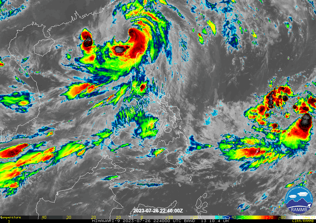
RAMMB/US NOAA/Himawari 8
MANILA — Typhoon Egay left the Philippine area of responsibility on Thursday morning after pounding northern parts of the country, the state weather bureau said, as another tropical cyclone threatened to stir more rains.
Egay left PAR at 8 a.m. and was on its way to the Taiwan Strait and China. At 10 a.m., Egay was estimated at 255 kilometers west of Itbayat, Batanes, packing maximum sustained winds of 150 kilometers per hour near the center and 185 kph gusts, PAGASA said.
In the next 3 days, the habagat enhanced by Egay would continue to bring occasional to monsoon rains over the western portions of Central Luzon and Southern Luzon, the weather agency said.
It kept wind signal 2 raised over Batanes, the northwestern portion of Cagayan (Claveria, Santa Praxedes) including Babuyan Islands, and the northern portion of Ilocos Norte (Pagudpud, Adams, Bangui, Dumalneg, Burgos).
ADVERTISEMENT
Structures made of light materials could be partially damaged or unroofed in these areas, while most banana plants and some trees could be broken, PAGASA said.
Signal 1 was raised over the following areas.
Signal 1 was raised over the following areas.
• Pangasinan • La Union • Ilocos Sur • Rest of Ilocos Norte • Rest of Cagayan • Apayao • Kalinga • Mountain Province • Ifugao • Abra • Benguet • Isabela • Quirino • Nueva Vizcaya • Northern portion of Aurora (Casiguran, Dinalungan, Dilasag) • Northern portion of Nueva Ecija (Cuyapo, Guimba, Pantabangan, Science City of Muñoz, Carranglan, San Jose City, Lupao, Nampicuan, Talugtug) • Northern portion of Tarlac (Paniqui, Moncada, Pura, Camiling, Ramos, San Manuel, Anao, San Clemente)
Meanwhile, a low pressure area (LPA) outside the Philippine area intensified into a tropical depression on Thursday morning, PAGASA said.
At 10 a.m., the new cyclone was spotted 1,585 kilometers east of Eastern Visayas, packing 55 kph maximum sustained winds and 70 kph gusts, the weather agency said.
It may enter PAR on Saturday evening or Sunday morning as a typhoon, and will be called Falcon.
While it is not expected to directly hit the country, the cyclone will enhance the habagat, which could bring more rains in parts of Luzon and the Visayas, PAGASA weather specialist Benison Estareja said.
"Inaasahan po natin hanggang sa unang araw ng Agosto ay magdadala pa rin ito ng pag-ulan dulot ng habagat na palalakasin nito sa mga susunod po na araw," Estareja said in a 5 a.m. Facebook update.
(We expect it to bring rains until the first day of August as it enhances the habagat.)
"Hanggang sa Tuesday, kikilos ito generally northwestward or mananatiling malayo pa rin po sa ating kalupaan habang nasa silangan ng northern Luzon," he added.
(Until Tuesday, it will move generally northwestward or stay far from land, while heading east of northern Luzon.)
The new cyclone comes after Egay toppled trees, knocked out power, and forced thousands to evacuate in northern Luzon this week, the disaster council said.
At least 5 people are feared dead due to the typhoon, authorities said.
ABS-CBN is the leading media and entertainment company in the Philippines, offering quality content across TV, radio, digital, and film. Committed to public service and promoting Filipino values, ABS-CBN continues to inspire and connect audiences worldwide.
Our website is made possible by displaying online
advertisements to our visitors. Please consider supporting
us by disabling your ad blocker on our website.
Our website is made possible by displaying online
advertisements to our visitors. Please consider supporting
us by disabling your ad blocker on our website.