Storm signal no. 2 up in Bicol areas as 'Ulysses' intensifies further | ABS-CBN


ADVERTISEMENT

Welcome, Kapamilya! We use cookies to improve your browsing experience. Continuing to use this site means you agree to our use of cookies. Tell me more!
Storm signal no. 2 up in Bicol areas as 'Ulysses' intensifies further
Storm signal no. 2 up in Bicol areas as 'Ulysses' intensifies further
Rose Carmelle Lacuata,
ABS-CBN News
Published Nov 10, 2020 05:52 PM PHT
|
Updated Nov 10, 2020 08:50 PM PHT

MANILA - State weather bureau PAGASA hoisted storm signal number 2 over several areas in the Bicol region as tropical storm Ulysses further intensified Tuesday afternoon.
MANILA - State weather bureau PAGASA hoisted storm signal number 2 over several areas in the Bicol region as tropical storm Ulysses further intensified Tuesday afternoon.
The country's 21st storm this year was last spotted 375 kilometers east northeast of Virac, Catanduanes as of 4 p.m., packing maximum sustained winds of 85 kilometers per hour near the center, with gusts of up to 105 kph, PAGASA said in its 5 p.m. weather bulletin.
The country's 21st storm this year was last spotted 375 kilometers east northeast of Virac, Catanduanes as of 4 p.m., packing maximum sustained winds of 85 kilometers per hour near the center, with gusts of up to 105 kph, PAGASA said in its 5 p.m. weather bulletin.
Tropical Cyclone Wind Signal no. 2 was raised over the following areas, where 61-120 kph winds may cause damage to high risk structures, and down old wooden electric posts:
Tropical Cyclone Wind Signal no. 2 was raised over the following areas, where 61-120 kph winds may cause damage to high risk structures, and down old wooden electric posts:
* Catanduanes
* Sorsogon
* Albay
* Camarines Sur
* the eastern portion of Camarines Norte (San Vicente, Talisay, Daet, San Lorenzo Ruiz, Basud, Mercedes)
* Catanduanes
* Sorsogon
* Albay
* Camarines Sur
* the eastern portion of Camarines Norte (San Vicente, Talisay, Daet, San Lorenzo Ruiz, Basud, Mercedes)
ADVERTISEMENT
Storm signal no. 1, meanwhile, was hoisted over the following areas, where 30-60 kph winds may rip roofs off nipa and cogon huts, damage rice crops and down banana plants:
Storm signal no. 1, meanwhile, was hoisted over the following areas, where 30-60 kph winds may rip roofs off nipa and cogon huts, damage rice crops and down banana plants:
* Metro Manila
* Quirino
* Nueva Vizcaya
* the eastern portion of Pangasinan (San Nicolas, Natividad, San Quintin, Umingan, Balungao, Rosales, Santa Maria, Tayug, Asingan, San Manuel)
* Aurora
* Nueva Ecija
* Tarlac
* Pamapanga
* Bulacan
* the central and southern portions of Zambales (Masinloc, Palauig, Iba, Botolan, Cabangan, San Felipe, San Narciso, San Marcelino, Castillejos, Subic, Olongapo City, San Antonio)
* Bataan
* Quezon including Polillo Islands
* Rizal
* Laguna
* Cavite
* Batangas
* the rest of Camarines Norte
* Masbate including Ticao and Burias Islands
* Marinduque
* Romblon
* Oriental Mindoro
* Occidental Mindoro including Lubang Island
* Northern Samar
* the northern portion of Samar (Santo Nino, Almagro, Tagapul-An, Tarangnan, Calbayog City, Santa Margarita, Gandara, Pagsanghan, San Jorge, San Jose de Buan, Matuguinao)
* the northern portion of Eastern Samar (Maslog, Dolores, Oras, San Policarpo, Arteche, Jipapad)
Ulysses is forecast to intensify into a severe tropical storm by Tuesday night, and into a typhoon by Wednesday.
Ulysses is forecast to intensify into a severe tropical storm by Tuesday night, and into a typhoon by Wednesday.
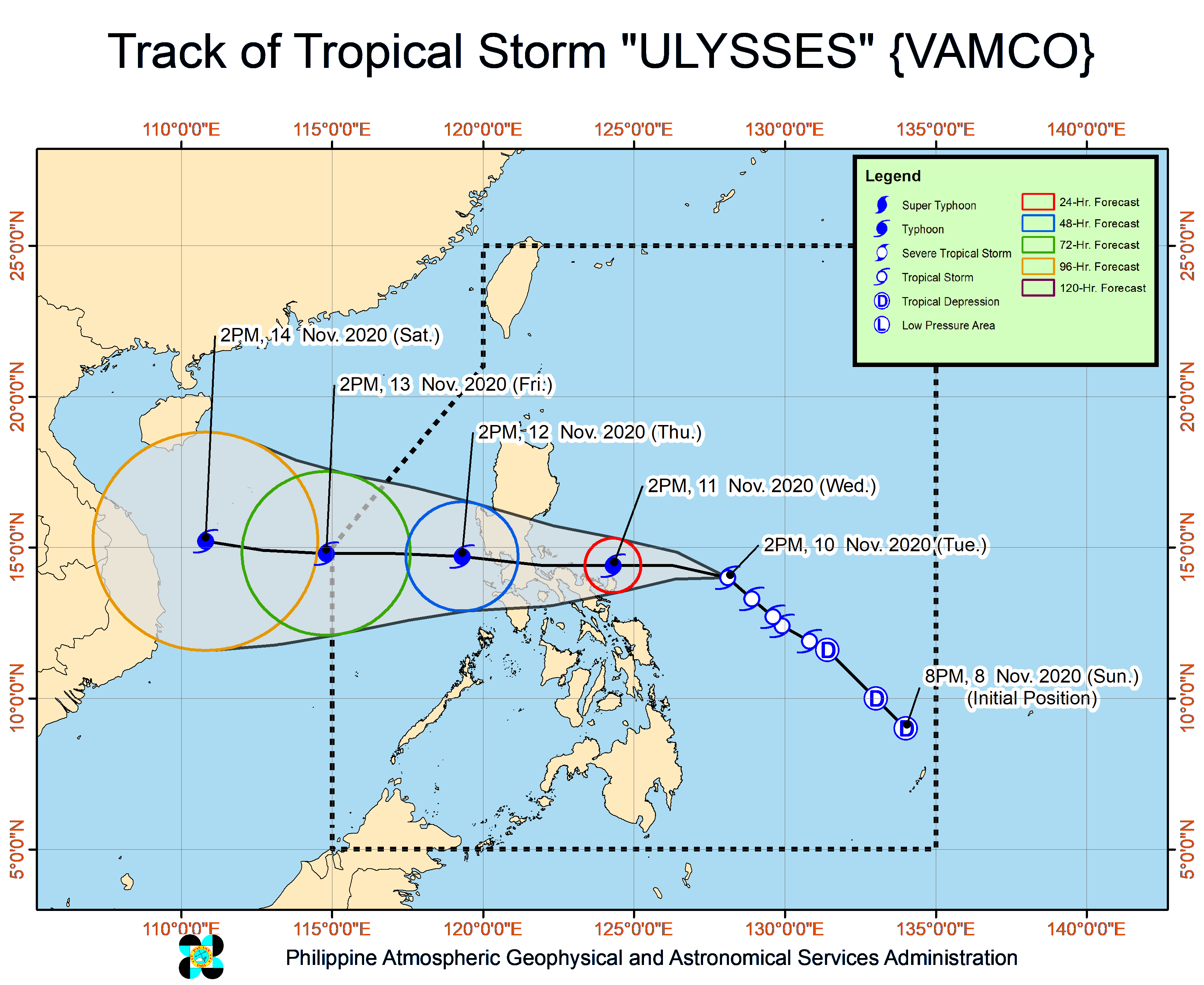
It is moving northwest at 15 kph and is forecast to move in the same direction throughout the day before turning west by Wednesday morning.
It is moving northwest at 15 kph and is forecast to move in the same direction throughout the day before turning west by Wednesday morning.
The storm t is expected to "closely approach" Catanduanes and Camarines Norte on Wednesday, and is forecast to make landfall over Quezon on Thursday morning, PAGASA said.
The storm t is expected to "closely approach" Catanduanes and Camarines Norte on Wednesday, and is forecast to make landfall over Quezon on Thursday morning, PAGASA said.
A "slight southward shift" in its track shows an "increasing likelihood of landfall" over Bicol region between Wednesday afternoon or evening, it added.
A "slight southward shift" in its track shows an "increasing likelihood of landfall" over Bicol region between Wednesday afternoon or evening, it added.
Ulysses comes as majority of the southern part of Luzon is still reeling from the onslaught of Super Typhoon Rolly on Nov. 1 and Typhoon Quinta on Oct. 25, which left billions of pesos in damage and killed dozens.
Ulysses comes as majority of the southern part of Luzon is still reeling from the onslaught of Super Typhoon Rolly on Nov. 1 and Typhoon Quinta on Oct. 25, which left billions of pesos in damage and killed dozens.
On Tuesday, Ulysses will bring light to moderate with at times heavy rains over Aurora, Quezon, Bicol Region, Eastern and Central Visayas, Caraga, Northern Mindanao, Zamboanga Peninsula, and Bangsamoro.
On Tuesday, Ulysses will bring light to moderate with at times heavy rains over Aurora, Quezon, Bicol Region, Eastern and Central Visayas, Caraga, Northern Mindanao, Zamboanga Peninsula, and Bangsamoro.
Moderate to heavy rains associated with the rainbands of Ulysses will begin affecting Bicol region and portions of Eastern Visayas on Wednesday, PAGASA said.
Moderate to heavy rains associated with the rainbands of Ulysses will begin affecting Bicol region and portions of Eastern Visayas on Wednesday, PAGASA said.
The tail-end of a cold front on Tuesday would bring light to moderate with at times heavy rains over Cagayan including Babuyan Islands, Isabela, Apayao, and Ilocos Norte.
The tail-end of a cold front on Tuesday would bring light to moderate with at times heavy rains over Cagayan including Babuyan Islands, Isabela, Apayao, and Ilocos Norte.
PAGASA warned that flooding, rain-induced landslides, and sediment-laden streamflows (e.g. lahar) may occur during heavy or prolonged rainfall especially in areas that are highly susceptible to these hazards.
PAGASA warned that flooding, rain-induced landslides, and sediment-laden streamflows (e.g. lahar) may occur during heavy or prolonged rainfall especially in areas that are highly susceptible to these hazards.
Visit the ABS-CBN Weather Center for updates.
Read More:
weather
weather top
PAGASA
UlyssesPH
tropical storm Ulysses
Bicol
Quezon
Calabarzon
Southern Luzon Ulysses
ADVERTISEMENT
ADVERTISEMENT