Welcome, Kapamilya! We use cookies to improve your browsing experience. Continuing to use this site means you agree to our use of cookies. Tell me more!
4 to 5 storms needed to bring Angat water level to normal: PAGASA
4 to 5 storms needed to bring Angat water level to normal: PAGASA
Ariel Rojas,
ABS-CBN News
Published Jul 14, 2023 03:45 PM PHT
|
Updated Jul 14, 2023 05:13 PM PHT
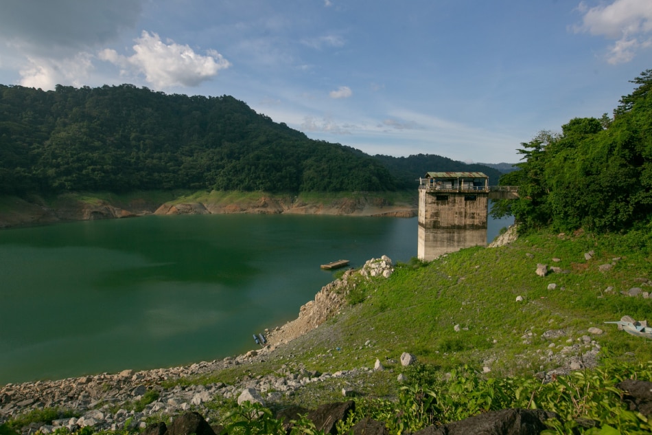
The water intake platform becomes visible as the water level at Angat Dam breaches the minimum operating level at 179 meters above sea level on July 8, 2023. Gigie Cruz, ABS-CBN News/File
MANILA — The water level in Angat Dam, where much of Metro Manila's water needs come from, may return to its normal level if 4 to 5 tropical cyclones pass by its watershed, state weather bureau PAGASA said on Friday.
One storm may only raise Angat's water level above the minimum operating level of 180 meters, PAGASA hydrologist Richard Orendain said.
The dam's normal high water level is 210 meters.
Angat Dam’s water level has been in steady decline since March. It recently breached its minimum operating level of 180 meters.
ADVERTISEMENT
Tropical depression Dodong and the southwest monsoon or habagat it enhances brought torrential rains in Luzon on Thursday, causing widespread flooding in Metro Manila and other nearby areas.
The Angat watershed received 65 millimeters of rainfall on Thursday, which caused the dam water level to decrease by only a centimeter from the previous day.
By Friday morning, the Angat water level increased to 179.09 meters, which was still below the minimum operating level.
Orendain explained that there is a lag time of 18 to 24 hours for the rains dumped upstream to reach the reservoir.
Hydrometeorology Division Chief Engr. Roy Badilla added that while the habagat would continue to bring rains over the watershed, it would not be enough to significantly raise Angat Dam's water level.
ADVERTISEMENT
Angat Dam supplies raw water to Metro Manila, Cavite, Rizal, and Bulacan.
On Wednesday, nearly 600,000 Maynilad customers in 6 Metro Manila cities started to experience 9 to 11-hour daily water service interruptions due to the continuous reduction of the dam's level amid the El Niño phenomenon when below-normal rainfall occurs.
PAGASA earlier explained that the country would not immediately feel the impacts of the prevailing El Niño. The habagat will continue to bring above-normal rains over the western section of Luzon for the remainder of the rainy season. Below-normal precipitation will be felt from the last quarter of the year and through next year’s first quarter.
STORM
As of 2 p.m. Friday, tropical depression Dodong was in the vicinity of Sanchez Mira, Cagayan, packing maximum winds of 45 kilometers per hour and up to 75 kph gusts. It was moving northwestward at 15 kph.
Tropical cyclone wind signal no. 1 was hoisted over Cagayan and the Babuyan Islands, Apayao, Ilocos Norte, Abra, Ilocos Sur, Mountain Province, Kalinga, and the northern portion of Isabela.
ADVERTISEMENT
Apart from strong winds, these areas will also experience heavy rains until Saturday afternoon. The wind signal elsewhere has been lifted.
Dodong is forecast to reach the West Philippine Sea by Friday afternoon or evening. It may intensify into a tropical storm before leaving the Philippine Area of Responsibility between Saturday evening and Sunday early morning.
Zambales, Bataan, Occidental Mindoro, and northern Palawan may continue to experience heavy monsoon rains as the disturbance moves away from the country. Gloomy weather and scattered rains may continue in other areas of central and southern Luzon including Metro Manila through mid-week next week.
ABS-CBN is the leading media and entertainment company in the Philippines, offering quality content across TV, radio, digital, and film. Committed to public service and promoting Filipino values, ABS-CBN continues to inspire and connect audiences worldwide.
Our website is made possible by displaying online
advertisements to our visitors. Please consider supporting
us by disabling your ad blocker on our website.
Our website is made possible by displaying online
advertisements to our visitors. Please consider supporting
us by disabling your ad blocker on our website.