Typhoon Ulysses weakens, set to exit Luzon | ABS-CBN


ADVERTISEMENT

Welcome, Kapamilya! We use cookies to improve your browsing experience. Continuing to use this site means you agree to our use of cookies. Tell me more!
Typhoon Ulysses weakens, set to exit Luzon
Typhoon Ulysses weakens, set to exit Luzon
ABS-CBN News
Published Nov 12, 2020 09:36 AM PHT
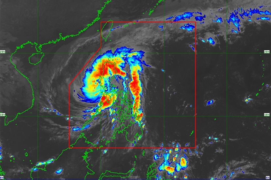
MANILA - Typhoon Ulysses weakened Thursday morning and is forecast to leave Luzon landmass in the next hour, the state weather bureau said.
MANILA - Typhoon Ulysses weakened Thursday morning and is forecast to leave Luzon landmass in the next hour, the state weather bureau said.
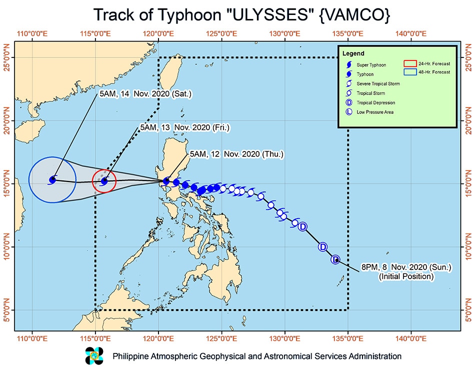
The country's 21st storm this year was last estimated in the vicinity of Cabangan, Zambales as of 7 a.m., moving west northwest at 30 km per hour while packing maximum winds of 130 kph near the center and gusts of up to 215 kph, PAGASA said.
The country's 21st storm this year was last estimated in the vicinity of Cabangan, Zambales as of 7 a.m., moving west northwest at 30 km per hour while packing maximum winds of 130 kph near the center and gusts of up to 215 kph, PAGASA said.
It is expected to emerge over the western seaboard of Zambales within the next hour and may intensify as it traverses the West Philippine Sea. It is forecast to leave the Philippine area of responsibility on Friday.
It is expected to emerge over the western seaboard of Zambales within the next hour and may intensify as it traverses the West Philippine Sea. It is forecast to leave the Philippine area of responsibility on Friday.
The storm left at least one dead and forced 170,000 to flee their homes as the COVID-19 pandemic persisted. It comes just a week after Super Typhoon Rolly devastated southern Luzon and left at least 19 dead.
The storm left at least one dead and forced 170,000 to flee their homes as the COVID-19 pandemic persisted. It comes just a week after Super Typhoon Rolly devastated southern Luzon and left at least 19 dead.
ADVERTISEMENT
On Thursday, Ulysses will bring heavy to intense with at times torrential rains over Metro Manila, Calabarzon, and Central Luzon while moderate to heavy with at times intense rains will prevail over the Cordilleras, mainland Cagayan Valley, Babuyan Islands, Pangasinan, Marinduque, and the northern portion of Mindoro Provinces including Lubang Island.
On Thursday, Ulysses will bring heavy to intense with at times torrential rains over Metro Manila, Calabarzon, and Central Luzon while moderate to heavy with at times intense rains will prevail over the Cordilleras, mainland Cagayan Valley, Babuyan Islands, Pangasinan, Marinduque, and the northern portion of Mindoro Provinces including Lubang Island.
Light to moderate with at times heavy rains will persist over Visayas and rest of Luzon.
Light to moderate with at times heavy rains will persist over Visayas and rest of Luzon.
PAGASA warned of flooding, rain-induced landslides, and sediment-laden streamflows (e.g. lahar) which may occur during heavy or prolonged rainfall especially in areas that are highly susceptible to these hazards and/or those that received previous heavy rainfall.
PAGASA warned of flooding, rain-induced landslides, and sediment-laden streamflows (e.g. lahar) which may occur during heavy or prolonged rainfall especially in areas that are highly susceptible to these hazards and/or those that received previous heavy rainfall.
Tropical cyclone wind signal no. 3 was raised in the following areas, where 121-170 kph winds are expected within 18 hours and may uproot trees and cause moderate to heavy damage:
Tropical cyclone wind signal no. 3 was raised in the following areas, where 121-170 kph winds are expected within 18 hours and may uproot trees and cause moderate to heavy damage:
- Metro Manila
- northern portion of Cavite (Naic, Tanza, Ternate, Maragondon, Rosario, Noveleta, Cavite City, Kawit, Bacoor, Imus, General Trias, Trece Martires City, Dasmariñas)
- western portion of Bulacan (San Miguel, San Ildefonso, San Rafael, Angat, Santa Maria, Marilao, Meycauayan City, Obando, Bulacan, Bocaue, Pandi, Bustos, Baliuag, Plaridel, Balagtas, Guiguinto, Malolos City, Paombong, Hagonoy, Calumpit, Pulilan)
- western portion of Nueva Ecija (Gapan City, Peñaranda, Santa Rosa, Cabanatuan City, General Mamerto Natividad, Llanera, San Jose City, Lupao, Cabiao, San Isidro, San Leonardo, Jaen, San Antonio, Zaragoza, Aliaga, Talavera, Licab, Quezon, Santo Domingo, Guimba, Muñoz City, Talugtug, Cuyapo, Nampicuan)
- Pampanga
- Tarlac
- Bataan
- Zambales
- Pangasinan
The following areas are under signal no. 2, where 61-120 kph winds are expected within 24 hours and may damage wooden and old electric posts:
The following areas are under signal no. 2, where 61-120 kph winds are expected within 24 hours and may damage wooden and old electric posts:
ADVERTISEMENT
- central and southern portions of Isabela (Mallig, Quirino, Ilagan, Roxas, Burgos, Gamu, Palanan, San Mariano, Dinapigue, San Guillermo, Benito Soliven, Naguilian, Reina Mercedes, Luna, San Manuel, Aurora, Cabatuan, Cauayan City, San Mateo, Alicia, Angadanan, Echague, Jones, San Agustin, San Isidro, Ramon, Santiago City, Cordon)
- Quirino
- Nueva Vizcaya
- Mountain Province
- Ifugao, Benguet
- southern portion of Ilocos Sur (Cervantes, Quirino, San Emilio, Lidlidda, Santiago, Banayoyo, Candon City, Galimuyod, Gregorio Del Pilar, Salcedo, Santa Lucia, Santa Cruz, Sigay, Suyo, Tagudin, Alilem, Sugpon)
- La Union
- Aurora
- rest of Nueva Ecija
- rest of Bulacan, the northern and central portion of Quezon (San Antonio, Tiaong, Dolores, Candelaria, Sariaya, Lucban, Tayabas City, Lucena City, Pagbilao, Perez, Alabat, Atimonan, Padre Burgos, Agdangan, Plaridel, Mauban, Sampaloc, Real, General Nakar, Infanta) including Polillo Islands
- Rizal
- Laguna
- rest of Cavite, Batangas, the northern portion of Oriental Mindoro (Puerto Galera, San Teodoro, Baco, Calapan City)
- northern portion of Occidental Mindoro (Paluan, Abra de Ilog) including Lubang Island
Signal No. 1 is hoisted over the following areas, where 30-60 kph winds may rip roofs off nipa and cogon huts, damage rice crops and down banana plants:
Signal No. 1 is hoisted over the following areas, where 30-60 kph winds may rip roofs off nipa and cogon huts, damage rice crops and down banana plants:
- rest of Isabela
- Kalinga
- Abra
- rest of Ilocos Sur
- rest of Occidental Mindoro, the rest of Oriental Mindoro
- Marinduque
- northern portion of Romblon (Corcuera, Banton, Concepcion), the rest of Quezon, Camarines Norte, and the western portion of Camarines Sur (Siruma, Tinambac, Calabanga, Bombon, Magarao, Canaman, Camaligan, Gainza, Pamplona, Pasacao, Libmanan, Cabusao, Sipocot, Lupi, Ragay, Del Gallego)
PAGASA said there was a high risk of storm surge with heights of up to 3 meters over the coastal areas of Metro Manila, Aurora, northern Quezon including Polillo Islands, Cavite, Bulacan, Pampanga, Bataan, and Zambales.
PAGASA said there was a high risk of storm surge with heights of up to 3 meters over the coastal areas of Metro Manila, Aurora, northern Quezon including Polillo Islands, Cavite, Bulacan, Pampanga, Bataan, and Zambales.
A storm surge of up to 2 meters may occur in the coastal areas of Isabela, La Union, Pangasinan, Batangas, the rest of Quezon, Marinduque, and the northern portion of Mindoro Provinces including Lubang Island.
A storm surge of up to 2 meters may occur in the coastal areas of Isabela, La Union, Pangasinan, Batangas, the rest of Quezon, Marinduque, and the northern portion of Mindoro Provinces including Lubang Island.
Storm surges, which may be accompanied by swells and/or breaking waves near the coast, can cause life-threatening and damaging coastal inundation, PAGASA said.
Storm surges, which may be accompanied by swells and/or breaking waves near the coast, can cause life-threatening and damaging coastal inundation, PAGASA said.
ADVERTISEMENT
ADVERTISEMENT