Welcome, Kapamilya! We use cookies to improve your browsing experience. Continuing to use this site means you agree to our use of cookies. Tell me more!
Maymay moves slowly over Philippine Sea, to make landfall over Aurora Thursday
Maymay moves slowly over Philippine Sea, to make landfall over Aurora Thursday
ABS-CBN News
Published Oct 11, 2022 11:30 PM PHT
Image from PAGASA
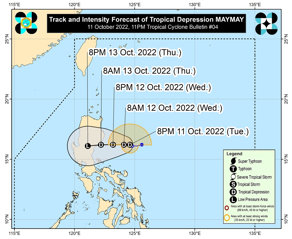
MANILA - Tropical Depression Maymay continues to move slowly over the Philippine Sea as it threatens the central and northern parts of Luzon, state weather bureau PAGASA said Tuesday night.
In its 11 p.m. weather bulletin, PAGASA said Maymay was located 270 kilometers east of Casiguran, Aurora as of 10 p.m., packing maximum sustained winds of 45 kilometers per hour (kph) near the center, with gusts of up to 55 kph.
It is moving south southwest slowly, and is expected to bring moderate to heavy with at times intense rains over Cagayan and Isabela until Wednesday afternoon.
Light to moderate with at times heavy rains may also prevail over Aurora.
ADVERTISEMENT
PAGASA raised Tropical Cyclone Wind Signal no. 1 over the following areas, where 39 to 61 kph winds and intermittent rains are expected within 36 hours.
Isabela
Quirino
Nueva Vizcaya
Aurora
Nueva Ecija
Extreme northern portion of Quezon (General Nakar, Infanta), including Polillo Islands
Maymay is forecasy to move slowly westward or remain almost stationary in the 12 hours before gradually accelerating westward toward Central Luzon.
It is expected to make landfall in the vicinity of Aurora by Thursday morning.
Forecast track of Tropical Depression Maymay. PAGASA
After making landfall, Maymay will traverse the central Luzon landmass.
PAGASA earlier said Maymay is expected to weaken into a low pressure area upon landfall.
ADVERTISEMENT
It also said another tropical depression, which will be given the local name “Neneng”, may enter the Philippine area of responsibility by Wednesday or Thursday.
ABS-CBN is the leading media and entertainment company in the Philippines, offering quality content across TV, radio, digital, and film. Committed to public service and promoting Filipino values, ABS-CBN continues to inspire and connect audiences worldwide.
Our website is made possible by displaying online
advertisements to our visitors. Please consider supporting
us by disabling your ad blocker on our website.
Our website is made possible by displaying online
advertisements to our visitors. Please consider supporting
us by disabling your ad blocker on our website.