Welcome, Kapamilya! We use cookies to improve your browsing experience. Continuing to use this site means you agree to our use of cookies. Tell me more!
New potential typhoon to enter Philippine area this week
New potential typhoon to enter Philippine area this week
Rowegie Abanto and Ariel Rojas,
ABS-CBN News
Published Aug 28, 2023 12:37 PM PHT
|
Updated Aug 28, 2023 02:28 PM PHT
PAGASA photo
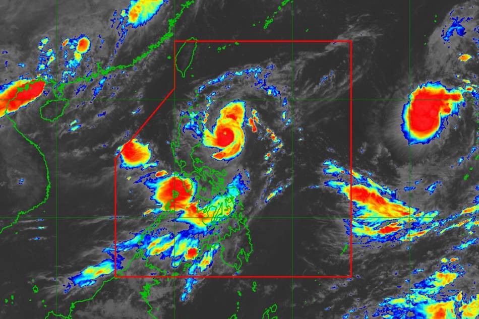
MANILA — A new potential typhoon may enter the Philippine area of responsibility this week as Goring continues to weaken while still threatening to bring rains, the state weather bureau said on Monday.
Tropical storm Haikui, spotted 2,230 kilometers east of northern Luzon at 10 a.m., was packing maximum sustained winds of 65 kilometers per hour and up to 80 kph gusts, according to PAGASA.
Moving westward at 15 kph, Haiku will continue to intensify and is predicted to enter the Philippine area as a typhoon by Wednesday or Thursday morning, PAGASA said.
It will be given the local name Hanna.
ADVERTISEMENT
The cyclone is not seen to hit land and will remain far from the Philippine landmass. But it could pull monsoon or habagat rains that would persist until the weekend.
Meanwhile, PAGASA said typhoon Goring continued to weaken on Monday morning but remained strong enough to stir heavy rains over northern Luzon.
Around 50 to 100 mm (around 2 to 4 inches) of rain is expected over the northeastern portion of mainland Cagayan on Monday.
The same rainfall amount will hit Batanes, Babuyan Islands, and the northern portions of mainland Cagayan, Apayao, and Ilocos Norte on Tuesday.
On Wednesday, up to 200 mm (nearly 8 inches) of rainfall may fall in Batanes, Babuyan Islands, and the northern portions of mainland Cagayan, Apayao, and Ilocos Norte.
Forecast rainfall is "generally higher in elevated or mountainous areas," PAGASA said. "Under these conditions, flooding and rain-induced landslides are still expected," it said.
Goring will also bring occasional or monsoon rains over the western portions of Central Luzon, Southern Luzon, and Visayas over the next 3 days, according to the weather agency.
At 10 a.m., Typhoon Goring was spotted at 245 kilometers east-northeast of Casiguran, Aurora, packing 155 kph maximum sustained winds and up to 190 kph gusts. It is moving north-northeastward at 15 kph.
Tropical cyclone wind signal number 1 was raised in the following areas, where 39-61 kph winds could be expected in 36 hours.
• Batanes • Babuyan Islands • Northern and eastern portions of mainland Cagayan (Camalaniugan, Pamplona, Gonzaga, Santa Teresita, Baggao, Buguey, Santa Ana, Claveria, Aparri, Ballesteros, Abulug, Sanchez-Mira, Santa Praxedes, Allacapan, Lal-Lo, Lasam, Peñablanca, Iguig, Amulung, Gattaran, Alcala) • Eastern portion of Isabela (Dinapigue, San Mariano, San Guillermo, Ilagan City, Tumauini, San Pablo, Cabagan, Maconacon, Divilacan, Palanan) • Northern and central portions of Aurora (Casiguran, Dinalungan, Dilasag, Baler, Dipaculao, Maria Aurora, San Luis) Polillo Islands • Northern and eastern portions of Camarines Norte (Capalonga, Jose Panganiban, Paracale, Vinzons, Talisay, Daet, Mercedes) including Calaguas Islands • Northeastern portion of Camarines Sur (Siruma, Tinambac, Lagonoy, Garchitorena, Caramoan) • Northern portion of Catanduanes (Panganiban, Caramoran, Viga, Bagamanoc, Pandan)
Some 500 families or nearly 2,000 individuals were sheltering in evacuation centers due to Goring, the National Disaster Risk Reduction and Management Council said.
It said it has yet to receive any report of deaths due to the typhoon.
“Mayroon pa tayong flooded areas, mayroon pa tayong mga report ng landslides and damage to houses. Pero so far, sa casualties, lalo na po yung mga nasawi, wala pa po,” NDRRMC spokesperson Director Edgar Posadas told TeleRadyo Serbisyo.
(We have flooded areas, reports of landslides, and damage to houses. But so far, we have no casualties yet.)
ABS-CBN is the leading media and entertainment company in the Philippines, offering quality content across TV, radio, digital, and film. Committed to public service and promoting Filipino values, ABS-CBN continues to inspire and connect audiences worldwide.
Our website is made possible by displaying online
advertisements to our visitors. Please consider supporting
us by disabling your ad blocker on our website.
Our website is made possible by displaying online
advertisements to our visitors. Please consider supporting
us by disabling your ad blocker on our website.