Welcome, Kapamilya! We use cookies to improve your browsing experience. Continuing to use this site means you agree to our use of cookies. Tell me more!
Goring weakens into typhoon, Signal no. 1 up in N. Luzon
Goring weakens into typhoon, Signal no. 1 up in N. Luzon
ABS-CBN News
Published Aug 28, 2023 06:45 AM PHT
|
Updated Aug 28, 2023 12:44 PM PHT
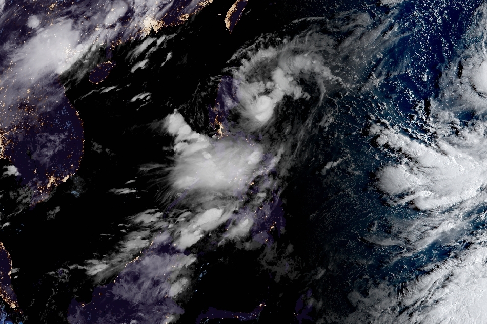
Imagery courtesy of the Japanese Meteorological Agency
Goring has weakened into a typhoon as it continues its counter-clockwise loop over the Philippine Sea early Monday, weather bureau PAGASA said.
As of 4 a.m., the center of the eye of the typhoon was estimated based on all available data, including those from Baler and Daet Weather Radars, at 210 km east of Casiguran, Aurora.
Packing 175 kph winds and 215 kph gusts, the typhoon is moving east southeastward at 15 kph.
PAGASA said Goring is forecast to slightly weaken further in the next 12 hours due to upwelling of cooler ocean waters and onset of dry air intrusion before re-intensifying as it turns northwestward.
ADVERTISEMENT
"It may be upgraded again to super typhoon category by mid tomorrow," the weather bureau said.
The typhoon will make a close approach (a landfall scenario is not ruled out) to Batanes between Wednesday morning and evening and to the southern portion of Taiwan between Wednesday evening and Thursday morning.
Tropical cyclone wind signal no 1 remains hoisted over the following areas:
Batanes, Babuyan Islands,
the northern and eastern portions of mainland Cagayan (Camalaniugan, Pamplona, Gonzaga, Santa Teresita, Baggao, Buguey, Santa Ana, Claveria, Aparri, Ballesteros, Abulug, Sanchez-Mira, Santa Praxedes, Allacapan, Lal-Lo, Lasam, Peñablanca, Iguig, Amulung, Gattaran, Alcala),
the eastern portion of Isabela (Dinapigue, San Mariano, San Guillermo, Ilagan City, Tumauini, San Pablo, Cabagan, Maconacon, Divilacan, Palanan),
the northern and central portions of Aurora (Casiguran, Dinalungan, Dilasag, Baler, Dipaculao, Maria Aurora, San Luis),
Polillo Islands,
the northern and eastern portions of Camarines Norte (Capalonga, Jose Panganiban, Paracale, Vinzons, Talisay, Daet, Mercedes) including Calaguas Islands,
the northeastern portion of Camarines Sur (Siruma, Tinambac, Lagonoy, Garchitorena, Caramoan), and the northern portion of Catanduanes (Panganiban, Caramoran, Viga, Bagamanoc, Pandan)
PAGASA has forecast 50-100mm of accumulated rainfall in northeastern portion of mainland Cagayan for Monday.
It said the southwest monsoon enhanced by Goring will bring occasional or monsoon rains over the western portions of Central Luzon, Southern Luzon, and Visayas over the next three days.
ABS-CBN is the leading media and entertainment company in the Philippines, offering quality content across TV, radio, digital, and film. Committed to public service and promoting Filipino values, ABS-CBN continues to inspire and connect audiences worldwide.
Our website is made possible by displaying online
advertisements to our visitors. Please consider supporting
us by disabling your ad blocker on our website.
Our website is made possible by displaying online
advertisements to our visitors. Please consider supporting
us by disabling your ad blocker on our website.