Typhoon Bising maintains strength as it turns north-northwest | ABS-CBN


ADVERTISEMENT

Welcome, Kapamilya! We use cookies to improve your browsing experience. Continuing to use this site means you agree to our use of cookies. Tell me more!
Typhoon Bising maintains strength as it turns north-northwest
Typhoon Bising maintains strength as it turns north-northwest
ABS-CBN News
Published Apr 19, 2021 05:36 AM PHT
|
Updated Apr 19, 2021 12:49 PM PHT
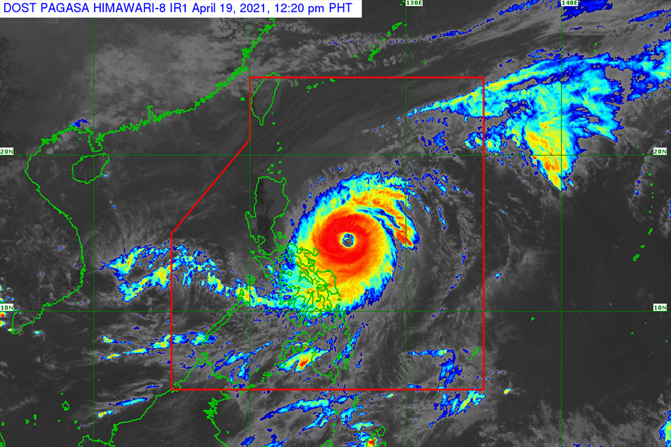
MANILA (2nd UPDATE) - Typhoon Bising maintained its strength as it slowly moved north-northwest on Monday morning, the state weather bureau said.
MANILA (2nd UPDATE) - Typhoon Bising maintained its strength as it slowly moved north-northwest on Monday morning, the state weather bureau said.
The country's second storm this year will bring moderate to heavy with at times intense rains over Bicol region and parts Eastern Visayas, according to PAGASA's 11 a.m. bulletin.
The country's second storm this year will bring moderate to heavy with at times intense rains over Bicol region and parts Eastern Visayas, according to PAGASA's 11 a.m. bulletin.
It was last estimated 235 kilometers east-northeast of Virac town, Catanduanes at 10 a.m., with maximum sustained winds of 195 km per hour near the center and gustiness of up to 240 kph, according to the state weather bureau.
It was last estimated 235 kilometers east-northeast of Virac town, Catanduanes at 10 a.m., with maximum sustained winds of 195 km per hour near the center and gustiness of up to 240 kph, according to the state weather bureau.
"Medyo malawak po itong si Bising. Almost 900 kilometers in diameter. Masuwerte po tayo dahil hindi ito magla-landfall. Kung ito ay tatama sa lupa, super devastating ito," PAGASA weather forecaster Ariel Rojas told ABS-CBN's TeleRadyo.
"Medyo malawak po itong si Bising. Almost 900 kilometers in diameter. Masuwerte po tayo dahil hindi ito magla-landfall. Kung ito ay tatama sa lupa, super devastating ito," PAGASA weather forecaster Ariel Rojas told ABS-CBN's TeleRadyo.
ADVERTISEMENT
(It's almost 900-kilometers in diameter. It's wide. We're lucky it won't make landfall. It will be super devastating if it hits land.)
(It's almost 900-kilometers in diameter. It's wide. We're lucky it won't make landfall. It will be super devastating if it hits land.)
Tropical cyclone wind signal No. 2, which may cause wooden, old electric posts to tilt, was raised in the following areas:
LUZON
Tropical cyclone wind signal No. 2, which may cause wooden, old electric posts to tilt, was raised in the following areas:
LUZON
- Catanduanes
- Eastern portion of Camarines Sur (Garchitorena, Presentacion, Caramoan, Sagnay, San Jose, Lagonoy)
- Eastern portion of Albay (Tiwi, Malinao, Tabaco City, Malilipot, Santo Domingo, Bacacay, Rapu-Rapu, Legazpi City, Manito)
- Eastern and central portions of Sorsogon (Castilla, Sorsogon City, Prieto Diaz, Gubat, Barcelona, Casiguran, Juban, Magallanes, Bulan, Bulusan, Irosin, Santa Magdalena, Matnog)
VISAYAS
- Northern Samar
- Samar
- Eastern Samar
- Biliran
- Northern Samar
- Samar
- Eastern Samar
- Biliran
Tropical cyclone wind signal No. 1, which may cause significant damage to rice crops in its flowering stage, was up in the following areas:
LUZON
Tropical cyclone wind signal No. 1, which may cause significant damage to rice crops in its flowering stage, was up in the following areas:
LUZON
- Southeastern portion of Cagayan (Baggao, Peñablanca)
- Eastern portion of Isabela (San Pablo, Maconacon, Tumauini, Divilacan, Ilagan City, Palanan, San Mariano, Dinapigue, San Guillermo, Echague, Benito Soliven, Cabagan, Gamu, Naguilian, Reina Mercedes, Angadanan, Cauayan City, Jones, San Agustin)
- Northeastern portion of Quirino (Aglipay, Maddela)
- Northern portion of Aurora ((Dilasag, Casiguran, Dinalungan)
- Eastern portion of Quezon (Calauag, Guinayangan, Tagkawayan, Buenavista, San Narciso, San Andres) including Polillo Islands
- Camarines Norte
- rest of Camarines Sur
- rest of Albay
- rest of Sorsogon
- Masbate including Burias and Ticao Islands
VISAYAS
- Leyte
- Southern Leyte
- Northern portion of Cebu (Tabogon, Borbon, San Remigio, Bogo City, Medellin, Daanbantayan) including Bantayan and Camotes Islands
- Leyte
- Southern Leyte
- Northern portion of Cebu (Tabogon, Borbon, San Remigio, Bogo City, Medellin, Daanbantayan) including Bantayan and Camotes Islands
MINDANAO
- Dinagat Islands
- Siargao Islands
- Bucas Grande Islands
- Dinagat Islands
- Siargao Islands
- Bucas Grande Islands
Bising is forecast to move generally northward or north northwestward until Wednesday evening or Thursday early morning, PAGASA said.
Bising is forecast to move generally northward or north northwestward until Wednesday evening or Thursday early morning, PAGASA said.
It will then turn east northeastward on Friday, away from the Luzon landmass, before it leaves the Philippine area of responsibility on Saturday, according to Rojas.
It will then turn east northeastward on Friday, away from the Luzon landmass, before it leaves the Philippine area of responsibility on Saturday, according to Rojas.
Nearly 18,500 families or 68,500 individuals in the Bicol Region and Eastern Visayas were preemptively evacuated, according to the National Disaster Risk Reduction and Management Council.
Nearly 18,500 families or 68,500 individuals in the Bicol Region and Eastern Visayas were preemptively evacuated, according to the National Disaster Risk Reduction and Management Council.
Flooding and power interruption were reported in some areas, while suspension of sea travel affected over 2,200 passengers, nearly 900 rolling cargoes, and 61 vessels.
Flooding and power interruption were reported in some areas, while suspension of sea travel affected over 2,200 passengers, nearly 900 rolling cargoes, and 61 vessels.
Some flights were cancelled as well.
Some flights were cancelled as well.
ADVERTISEMENT
ADVERTISEMENT