Bising weakens further as it moves slowly over PH sea | ABS-CBN

Welcome, Kapamilya! We use cookies to improve your browsing experience. Continuing to use this site means you agree to our use of cookies. Tell me more!
Bising weakens further as it moves slowly over PH sea
Bising weakens further as it moves slowly over PH sea
ABS-CBN News
Published Apr 18, 2021 11:52 PM PHT
|
Updated Apr 19, 2021 05:37 AM PHT
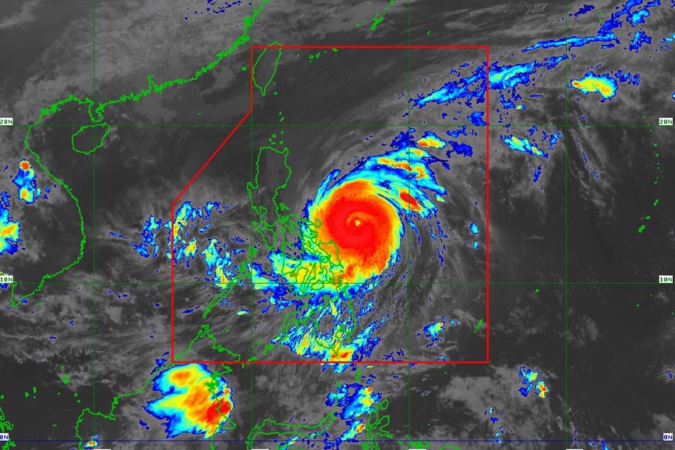
MANILA— Typhoon Bising (international name Surigae) weakened further as it moved over the Philippine Sea, the state weather bureau said Sunday night.
MANILA— Typhoon Bising (international name Surigae) weakened further as it moved over the Philippine Sea, the state weather bureau said Sunday night.
The country's second storm this year will bring moderate to heavy with at times intense rains over Bicol region, Northern Samar, Samar, Eastern Samar, Biliran and Leyte from Sunday night until Monday, PAGASA said in its 11 p.m. weather bulletin.
The country's second storm this year will bring moderate to heavy with at times intense rains over Bicol region, Northern Samar, Samar, Eastern Samar, Biliran and Leyte from Sunday night until Monday, PAGASA said in its 11 p.m. weather bulletin.
The following areas were placed under tropical cyclone wind signal no. 2, where winds of up to 120 kph may be expected in at least 24 hours, which may cause old wooden electric posts to be tilted or downed:
The following areas were placed under tropical cyclone wind signal no. 2, where winds of up to 120 kph may be expected in at least 24 hours, which may cause old wooden electric posts to be tilted or downed:
- Catanduanes
- Eastern portion of Camarines Sur eastern portion of Camarines Sur (Garchitorena, Presentacion, Caramoan, Sagnay, San Jose, Lagonoy)
- Eastern portion of Albay (Tiwi, Malinao, Tabaco City, Malilipot, Santo Domingo, Bacacay, Rapu-Rapu, Legazpi City, Manito)
- Eastern and central portions of Sorsogon (Castilla, Sorsogon City, Prieto Diaz, Gubat, Barcelona, Casiguran, Juban, Magallanes, Bulan, Bulusan, Irosin, Santa Magdalena, Matnog)
- Northern Samar
- Eastern Samar
- Samar
- Biliran
Storm signal no. 1, which may cause slight damage to some houses of very light materials or makeshift structures in exposed communities, was hoisted over the following areas:
Storm signal no. 1, which may cause slight damage to some houses of very light materials or makeshift structures in exposed communities, was hoisted over the following areas:
ADVERTISEMENT
- Eastern portion of Camarines Norte (San Lorenzo Ruiz, San Vicente, Vinzons, Talisay, Daet, Mercedes, Basud)
- Rest of Camarines Sur
- Rest of Albay
- Rest of Sorsogon
- Masbate including Burias and Ticao Islands
- Leyte
- Southern Leyte
- Northern portion of Cebu (Tabogon, Borbon, San Remigio, Bogo City, Medellin, Daanbantayan) including Bantayan and Camotes Islands
- Dinagat Islands
- Siargao Islands
- Bucas Grande Islands
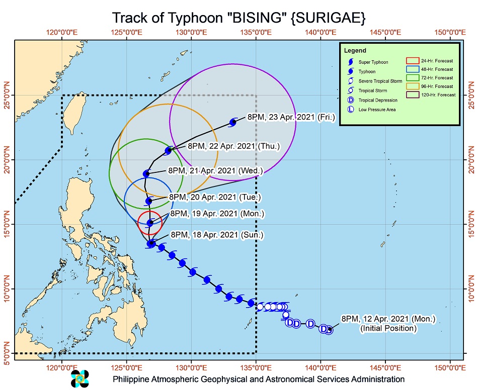
Bising was last estimated 270 kilometers east of Virac town, Catanduanes, moving slowly west northwestward.
Bising was last estimated 270 kilometers east of Virac town, Catanduanes, moving slowly west northwestward.
It was packing 195 km per hour (kph) maximum winds near the center and gusts of up to 240 kph, according to PAGASA.
It was packing 195 km per hour (kph) maximum winds near the center and gusts of up to 240 kph, according to PAGASA.
It was forecast to continue moving slowly in the next 6 to 12 hours as it begins to turn generally northward over the Philippine Sea, PAGASA said.
It was forecast to continue moving slowly in the next 6 to 12 hours as it begins to turn generally northward over the Philippine Sea, PAGASA said.
It will then turn northward while gradually accelerating until Wednesday before turning northeastward and east northeastward away from the Luzon landmass, PAGASA added.
It will then turn northward while gradually accelerating until Wednesday before turning northeastward and east northeastward away from the Luzon landmass, PAGASA added.
"The recent weakening of Bising after reaching its peak intensity was caused by a recently completed eyewall replacement cycle. The typhoon is forecast to maintain its current intensity in the next 24 to 48 hours before gradually weakening throughout the remainder of the forecast period," it also said.
"The recent weakening of Bising after reaching its peak intensity was caused by a recently completed eyewall replacement cycle. The typhoon is forecast to maintain its current intensity in the next 24 to 48 hours before gradually weakening throughout the remainder of the forecast period," it also said.
The PAGASA warned that very rough to very high seas will be experienced over the northern and eastern seaboard of Luzon (5.0 to 12.0 m), rough to very high seas over the eastern seaboard of Eastern Visayas (2.5 to 7.0 m), and rough to very rough seas over the northern and western seaboard of Northern Luzon (2.5 to 5.0 m) and the eastern seabord of Caraga (2.5 to 4.0 m),
The PAGASA warned that very rough to very high seas will be experienced over the northern and eastern seaboard of Luzon (5.0 to 12.0 m), rough to very high seas over the eastern seaboard of Eastern Visayas (2.5 to 7.0 m), and rough to very rough seas over the northern and western seaboard of Northern Luzon (2.5 to 5.0 m) and the eastern seabord of Caraga (2.5 to 4.0 m),
Rough seas are also expected over the remaining seaboards of localities where wind signals are in effect and the eastern seaboard of Davao Oriental (2.5 to 4.0 m), while moderate to rough seas may be experienced over the western seaboard of Central Luzon (1.2 to 3.0 m).
Rough seas are also expected over the remaining seaboards of localities where wind signals are in effect and the eastern seaboard of Davao Oriental (2.5 to 4.0 m), while moderate to rough seas may be experienced over the western seaboard of Central Luzon (1.2 to 3.0 m).
Sea travel is risky for all types of seacraft over these waters, especially those under storm signals, it said.
Sea travel is risky for all types of seacraft over these waters, especially those under storm signals, it said.
Globe Telecoms said Saturday its technical and support personnel and generators were on standby in areas threatened by Typhoon Bising.
Globe Telecoms said Saturday its technical and support personnel and generators were on standby in areas threatened by Typhoon Bising.
It said its Libreng Tawag, charging, and WiFi services will be deployed in areas where the typhoon was forecast to bring heavy rains and strong winds.
It said its Libreng Tawag, charging, and WiFi services will be deployed in areas where the typhoon was forecast to bring heavy rains and strong winds.
RELATED VIDEO
ADVERTISEMENT
ADVERTISEMENT


