Typhoon Odette hammers northern Bohol | ABS-CBN


ADVERTISEMENT

Welcome, Kapamilya! We use cookies to improve your browsing experience. Continuing to use this site means you agree to our use of cookies. Tell me more!
Typhoon Odette hammers northern Bohol
Typhoon Odette hammers northern Bohol
Mico Abarro,
ABS-CBN News
Published Dec 16, 2021 09:00 PM PHT
|
Updated Dec 16, 2021 09:19 PM PHT
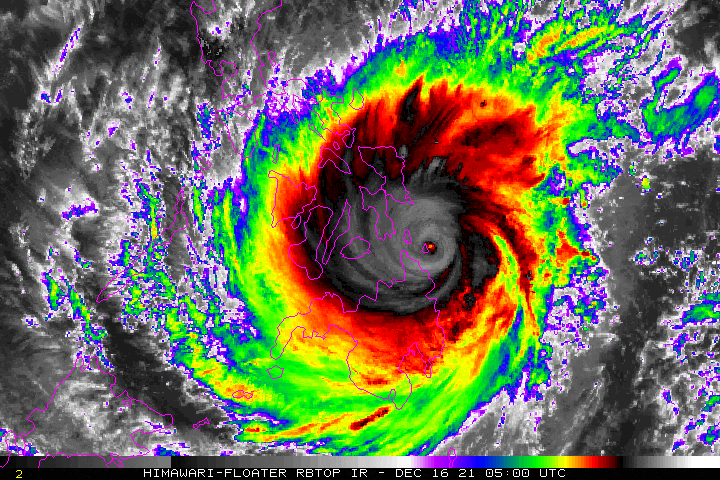
MANILA (UPDATED) - Typhoon Odette slightly weakened as it struck northern Bohol on Thursday night, state weather bureau PAGASA said.
MANILA (UPDATED) - Typhoon Odette slightly weakened as it struck northern Bohol on Thursday night, state weather bureau PAGASA said.
The typhoon's center was last spotted 7:00 p.m. over the coastal waters of Pres. Carlos P. Garcia, Bohol. Odette later made its sixth landfall, 7:30 p.m., at Bien Unido, Bohol.
The typhoon's center was last spotted 7:00 p.m. over the coastal waters of Pres. Carlos P. Garcia, Bohol. Odette later made its sixth landfall, 7:30 p.m., at Bien Unido, Bohol.
The tropical cyclone was moving with maximum sustained winds of 185 kph with gustiness of up to 255 kph. It was moving westward at 30 kph.
The tropical cyclone was moving with maximum sustained winds of 185 kph with gustiness of up to 255 kph. It was moving westward at 30 kph.
The tropical cyclone was moving with maximum sustained winds of 185 kph with gustiness of up to 255 kph. It was moving westward at 30 kph.
The tropical cyclone was moving with maximum sustained winds of 185 kph with gustiness of up to 255 kph. It was moving westward at 30 kph.
ADVERTISEMENT
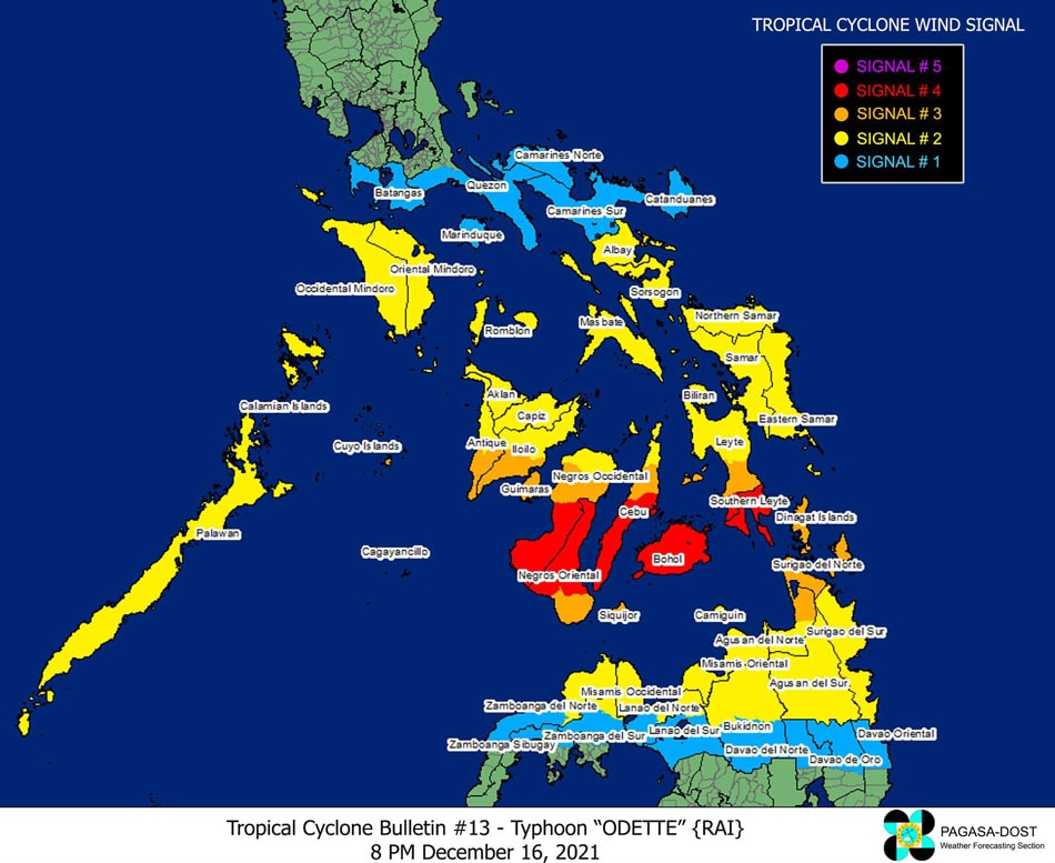
PAGASA said from Thursday night to Friday morning, heavy to torrential rains will fall over Central Visayas, Misamis Oriental, Camiguin, Bukidnon, Southern Leyte, and Negros Occidental. Wind speeds may also reach up to 185 kph at any areas under Tropical Cyclone Warning Signal number 4.
PAGASA said from Thursday night to Friday morning, heavy to torrential rains will fall over Central Visayas, Misamis Oriental, Camiguin, Bukidnon, Southern Leyte, and Negros Occidental. Wind speeds may also reach up to 185 kph at any areas under Tropical Cyclone Warning Signal number 4.

Areas under Tropical Cyclone Warning Signal number 4:
Areas under Tropical Cyclone Warning Signal number 4:
- Southern Leyte
- Southwestern portion of Leyte
- Bohol
- Central and southern portions of Cebu
- Central and southern portions of Negros Oriental
- Central and southern portions of Negros Occidental
- Southern Leyte
- Southwestern portion of Leyte
- Bohol
- Central and southern portions of Cebu
- Central and southern portions of Negros Oriental
- Central and southern portions of Negros Occidental
Areas under Tropical Cyclone Warning Signal number 3:
Areas under Tropical Cyclone Warning Signal number 3:
- Northern portion of Agusan del Norte
- Dinagat Islands
- Surigao del Norte
- Rest of southern portion of Leyte
- Northern portion of Cebu
- Rest of Negros Oriental
- Siquijor
- Northern portion of Negros Occidental
- Guimaras
- Southern portion of Iloilo
- Southern portion of Antique
- Cagayancillo and Cuyo Islands
Areas under Tropical Cyclone Warning Signal number 2:
Areas under Tropical Cyclone Warning Signal number 2:
- Surigao del Sur
- Agusan del Sur
- The rest of Agusal del Norte
- Extreme northern portion of Zamboanga del Norte
- The extreme northern portion of Zamboanga del Sur
- Misamis Occidental
- The northern portion of Lanao del Norte
- Misamis Oriental
- Camiguin
- The northern portion of Bukidnon
- The northern portion of Lanao del Sur
- Northern Samar
- Eastern Samar
- Samar
- Biliran
- The rest of Leyte
- The rest of Cebu
- The rest of Negros Occidental
- The rest of Iloilo
- Capiz
- Aklan
- The rest of Antique
- Albay
- Sorsogon
- Masbate
- Romblon
- Oriental Mindoro
- Occidental Mindoro
- Mainland Palawan including Kalayaan, Balabac, and Calamian Islands
Areas under Tropical Cyclone Warning Signal number 1:
Areas under Tropical Cyclone Warning Signal number 1:
- The northern portion of Davao Oriental
- The northern portion of Davao de Oro
- The northern portion of Davao del Norte
- The rest of Bukidnon
- The rest of Lanao del Norte
- The rest of Lanao del Sur
- The rest of the northern portion of Zamboanga del Norte
- The rest of the northern portion of Zamboanga del Sur
- The northern portion of Zamboanga Sibugay
- Catanduanes
- Camarines Norte
- Camarines Sur
- The rest of Albay
- Marinduque
- The southern portion of Quezon
- Batangas
The weather bureau also warned of moderate to high risk of storm surges in coastal areas of Central Visayas, Iloilo, Guimaras, Negros Occidental, Southern Leyte, Dinagat Islands, Surigao del Norte, Surigao del Sur, Agusan del Norte, parts of Northern Palawan, Antique, southern portions of Samar and Eastern Samar, Leyte, and Misamis Oriental.
The weather bureau also warned of moderate to high risk of storm surges in coastal areas of Central Visayas, Iloilo, Guimaras, Negros Occidental, Southern Leyte, Dinagat Islands, Surigao del Norte, Surigao del Sur, Agusan del Norte, parts of Northern Palawan, Antique, southern portions of Samar and Eastern Samar, Leyte, and Misamis Oriental.
PAGASA expects Odette to continue moving westward and cross several provinces in Central and Western Visayas before emerging over the Sulu Sea on Friday morning. It is then expected to hit Northern or Central Palawan by Friday afternoon, before crossing over toward the West Philippine Sea.
PAGASA expects Odette to continue moving westward and cross several provinces in Central and Western Visayas before emerging over the Sulu Sea on Friday morning. It is then expected to hit Northern or Central Palawan by Friday afternoon, before crossing over toward the West Philippine Sea.
The state weather bureau will post its next update on Typhoon Odette at 11:00 p.m.
The state weather bureau will post its next update on Typhoon Odette at 11:00 p.m.
ADVERTISEMENT
ADVERTISEMENT