Tropical Depression Rosal maintains strength over Philippine Sea | ABS-CBN
ADVERTISEMENT

Welcome, Kapamilya! We use cookies to improve your browsing experience. Continuing to use this site means you agree to our use of cookies. Tell me more!
Tropical Depression Rosal maintains strength over Philippine Sea
Tropical Depression Rosal maintains strength over Philippine Sea
ABS-CBN News
Published Dec 10, 2022 06:17 PM PHT
|
Updated Dec 11, 2022 12:18 AM PHT
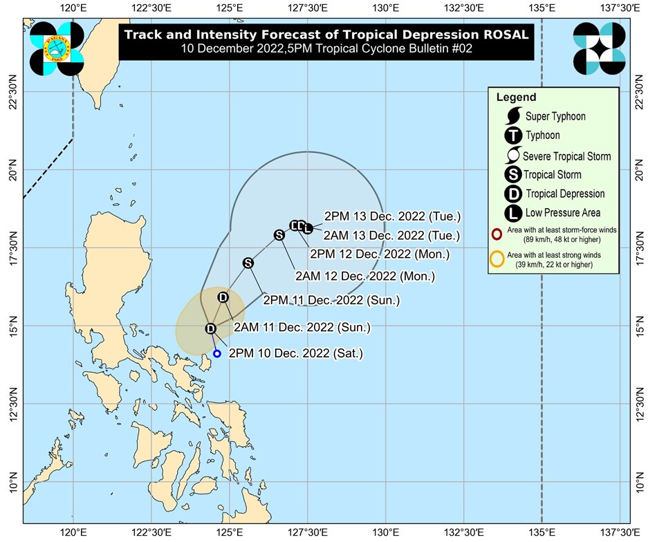
MANILA (UPDATED) - Tropical Depression Rosal maintained its strength as it moved northward over the Philippine Sea, east of Casiguran, Aurora late Saturday, according to state weather bureau PAGASA.
MANILA (UPDATED) - Tropical Depression Rosal maintained its strength as it moved northward over the Philippine Sea, east of Casiguran, Aurora late Saturday, according to state weather bureau PAGASA.
Although the tropical depression maintained its strength, storm signals over Catanduanes (Pandan, Gigmoto, Bagamanoc, Panganiban, Viga, Caramoran) were lifted as of PAGASA's 11 p.m. update.
Although the tropical depression maintained its strength, storm signals over Catanduanes (Pandan, Gigmoto, Bagamanoc, Panganiban, Viga, Caramoran) were lifted as of PAGASA's 11 p.m. update.
The center of Rosal was last spotted 355 kilometers East Northeast of Infanta, Quezon, packing sustained winds of 45 kilometers per hour with gusts reaching 55kph.
The center of Rosal was last spotted 355 kilometers East Northeast of Infanta, Quezon, packing sustained winds of 45 kilometers per hour with gusts reaching 55kph.
The tropical cyclone is moving northward at 10 kph.
The tropical cyclone is moving northward at 10 kph.
ADVERTISEMENT
Rosal is set to move away northwestward from Luzon in the coming days, according to PAGASA.
Rosal is set to move away northwestward from Luzon in the coming days, according to PAGASA.
PAGASA said in the next 24 hours, occasional gusts associated with the northeast monsoon may also be experienced over Batanes and Babuyan Islands.
PAGASA said in the next 24 hours, occasional gusts associated with the northeast monsoon may also be experienced over Batanes and Babuyan Islands.
Strong breeze to near-gale strength may also be experienced over the Ilocos Norte, the northern and eastern portions of Cagayan, the eastern portion of Isabela, Calaguas Islands, and the extreme northern portion of Catanduanes.
Strong breeze to near-gale strength may also be experienced over the Ilocos Norte, the northern and eastern portions of Cagayan, the eastern portion of Isabela, Calaguas Islands, and the extreme northern portion of Catanduanes.
The combined effects of the surge of the Northeast Monsoon and the tropical cyclone may also bring moderate to rough seas over the seaboards of Central Luzon and the eastern and western seaboards of Southern Luzon.
The combined effects of the surge of the Northeast Monsoon and the tropical cyclone may also bring moderate to rough seas over the seaboards of Central Luzon and the eastern and western seaboards of Southern Luzon.
"This means conditions may be risky for those using small seacrafts," PAGASA said.
"This means conditions may be risky for those using small seacrafts," PAGASA said.
The next tropical cyclone bulletin will be issued by PAGASA at 5 a.m. Sunday.
The next tropical cyclone bulletin will be issued by PAGASA at 5 a.m. Sunday.
Read More:
LPA
low pressure area
tropical depression
weather
weather news
weather today
bagyo
storm
weather latest
weather updates
ADVERTISEMENT
ADVERTISEMENT


