Welcome, Kapamilya! We use cookies to improve your browsing experience. Continuing to use this site means you agree to our use of cookies. Tell me more!
Typhoon Goring moves closer to extreme northern Luzon
Typhoon Goring moves closer to extreme northern Luzon
ABS-CBN News
Published Aug 29, 2023 12:52 AM PHT
|
Updated Aug 29, 2023 07:38 AM PHT
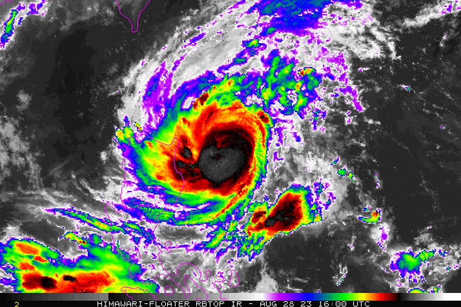
Typhoon Goring. NOAA/Himawari-8
MANILA - The state weather bureau hoisted Tropical Cyclone Wind Signal No. 2 anew over Batanes and parts of Cagayan as typhoon Goring (international name: Saola) moved closer to extreme northern Luzon late Monday.
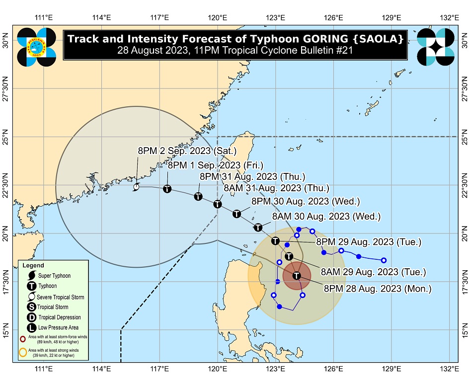
In its 11 p.m. weather bulletin, PAGASA said Goring was spotted around 240 kilometers east of Tuguegarao City, Cagayan, packing maximum sustained winds of 155 kilometers per hour near the center, with gusts of up to 190 kph.
It is currently moving north northwestward at 10 kph, and is expected to turn generally northwestward through Wednesday as it moves over the Luzon Strait.
The typhoon may dump between 50 to 100 millimeter of rainfall over Batanes, Babuyan Islands, the northern portion of Ilocos Norte, and the northern and eastern portions of mainland Cagayan until Tuesday night.
ADVERTISEMENT
"Under these conditions, flooding and rain-induced landslides are possible especially in areas that are highly or very highly susceptible to these hazards," PAGASA warned.
Goring will also enhance the southwest monsoon, which will bring occasional rains over the western portions of Central Luzon, Southern Luzon, and Visayas over the next three days, PAGASA said.
Between Monday night to Tuesday night, Zambales, Bataan, Cavite, Batangas, northern portion of Palawan including Calamian and Cuyo Islands, Antique, southwestern portion of Iloilo and the northwestern portion of Aklan will experience between 50 to 100 millimeter of rainfall.
Occidental Mindoro, on the other hand, will experience between 100 to 200 mm of rainfall during the same period.
Aside from Batanes, Signal No. 2 was also hoisted over Babuyan Islands and the extreme northeastern portion of mainland Cagayan (Santa Ana, Gonzaga).
“Kasalukuyan mayroon na tayong nakataas na Tropical Cyclone Wind Signal No. 2 dahil nga mas papalapit na muli itong si bagyong Goring dito sa area ng extreme northern Luzon,” weather specialist Grace Castañeda explained.
Tropical Cyclone Wind Signal No. 1 remains hoisted over the following areas:
Northern and eastern portions of mainland Cagayan (Camalaniugan, Pamplona, Gonzaga, Santa Teresita, Baggao, Buguey, Santa Ana, Claveria, Aparri, Ballesteros, Abulug, Sanchez-Mira, Santa Praxedes, Allacapan, Lal-Lo, Lasam, Peñablanca, Iguig, Amulung, Gattaran, Alcala, Santo Niño)
Eastern portion of Isabela (Dinapigue, San Mariano, Ilagan City, Tumauini, San Pablo, Cabagan, Maconacon, Divilacan, Palanan)
Northern portion of Apayao (Flora, Calanasan, Luna, Pudtol, Santa Marcela)
PAGASA said Goring will make close approach or landfall in the vicinity of Batanes between Wednesday morning and afternoon.
Goring is forecast to exit the Philippine area of responsibility between Thursday morning or afternoon.
It is also expected to re-intensify over the next two to three days as it moves over the Luzon Strait.
Meanwhile, the tropical depression outside PAR has intensified into a tropical storm, with the international name Haikui.
As of 11 p.m., it is located 1,965 kilometers east of northern Luzon.
PAGASA said it may enter PAR by Wednesday afternoon or evening and will be assigned the local name “Hanna”.
Although it is less likely to directly affect the country, PAGASA said it may enhance the habagat beginning Wednesday or Thursday, and may bring occasional or monsoon rains over the western portion of Luzon and Visayas.
ABS-CBN is the leading media and entertainment company in the Philippines, offering quality content across TV, radio, digital, and film. Committed to public service and promoting Filipino values, ABS-CBN continues to inspire and connect audiences worldwide.
Our website is made possible by displaying online
advertisements to our visitors. Please consider supporting
us by disabling your ad blocker on our website.
Our website is made possible by displaying online
advertisements to our visitors. Please consider supporting
us by disabling your ad blocker on our website.