Welcome, Kapamilya! We use cookies to improve your browsing experience. Continuing to use this site means you agree to our use of cookies. Tell me more!
Typhoon Egay makes 2nd landfall; Signal 4 up in parts of Cagayan, Apayao, Ilocos Norte
Typhoon Egay makes 2nd landfall; Signal 4 up in parts of Cagayan, Apayao, Ilocos Norte
Rowegie Abanto,
ABS-CBN News
Published Jul 26, 2023 12:30 PM PHT
|
Updated Jul 26, 2023 05:56 PM PHT
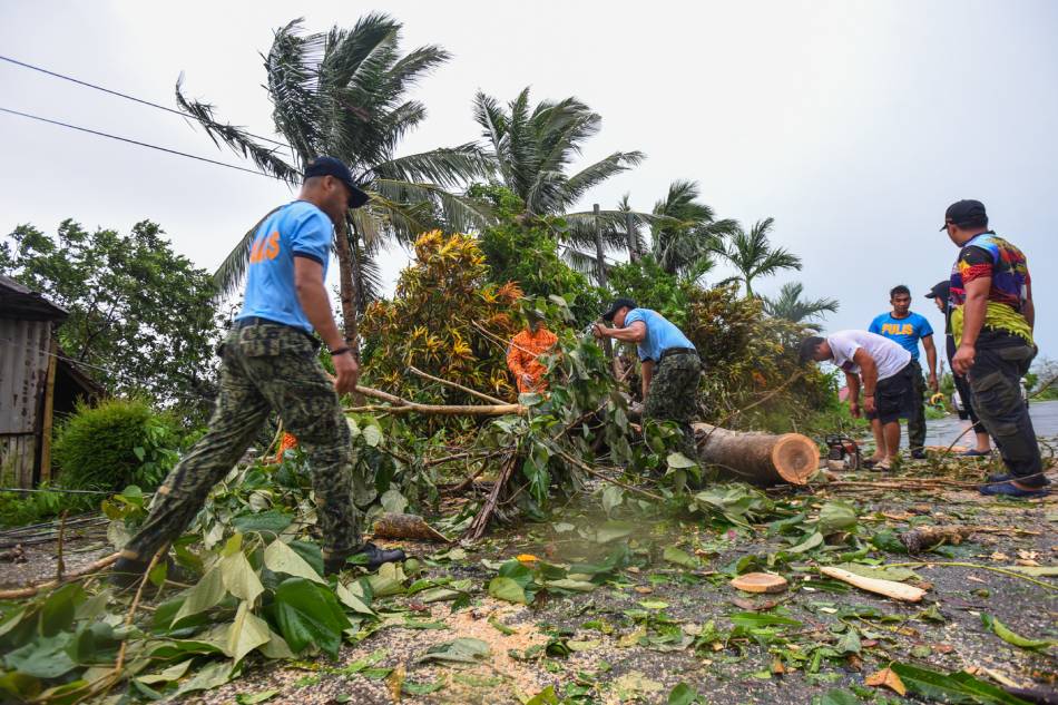
Personnel from the Philippine National Police, Bureau of Fire Protection, and Emergency Rescue Team conduct a clearing operation along Barangay Rapuli road in Santa Ana, Cagayan Province as Typhoon Egay batters northern Luzon on July 26, 2023. Maria Tan, ABS-CBN News
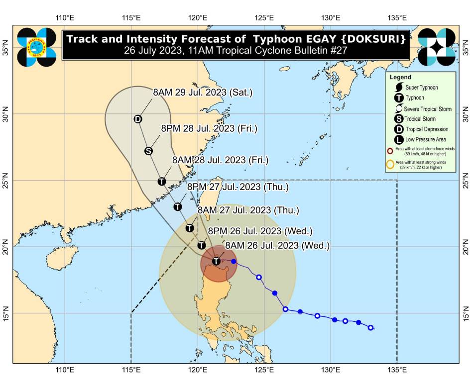
MANILA (UPDATED) — Typhoon Egay maintained its strength and hit land for a second time before Wednesday noon, the state weather bureau said, as it kept wind signals raised over vast swaths of Luzon.
Egay made its second landfall over Dalupiri Island in Calayan, Cagayan province on Wednesday, PAGASA said.
At 1 p.m., the typhoon was spotted over the coastal waters of Calayan, packing maximum sustained winds of 175 kilometers per hour and up to 240 kph gusts, the weather agency said.
"Violent, life-threatening conditions are expected to continue over Babuyan Islands, the northwestern portion of mainland Cagayan, and the northern portions of Apayao and Ilocos Norte in the next 6 hours," PAGASA warned. Storm surges exceeding three meters may cause flooding in some low-lying and coastal areas in Batanes, Cagayan, Babuyan Islands, Ilocos Norte, and portions of Isabela and Ilocos Sur, it added.
PAGASA kept Signal 4 raised in the following areas, where 118 to 184 kph winds could rip off roofs and break trees.
Northern portion of Cagayan (Santa Ana, Gonzaga, Claveria, Sanchez-Mira, Pamplona, Abulug, Ballesteros, Aparri, Buguey, Santa Teresita, Camalaniugan, Santa Praxedes) including Babuyan Islands
Northern portion of Apayao (Calanasan, Luna, Santa Marcela)
Northern portion of Ilocos Norte (Burgos, Bangui, Dumalneg, Pagudpud, Adams, Pasuquin, Vintar, Bacarra)
The weather agency also raised the following tropical cyclone wind signals.
SIGNAL NO. 3
Winds may damage half of old, dilapidated houses made of light materials, and down almost all banana plants.
Batanes
Rest of Cagayan
Rest of Apayao
Northern portion of Kalinga (Rizal, Pinukpuk, Balbalan)
Northern portion of Abra (Tineg, Lagayan, Lacub, Danglas, Bangued, La Paz, San Juan, Dolores, Tayum, Lagangilang, Malibcong, Licuan-Baay, Peñarrubia, Pidigan, Langiden, San Quintin, Bucay, San Isidro, Sallapadan)
Rest of Ilocos Norte
Northern portion of Ilocos Sur (Magsingal, San Juan,
Cabugao, Sinait, San Vicente, Santo Domingo, San Ildefonso, Bantay,
Santa Catalina, City of Vigan, Caoayan, Santa, Nagbukel, Narvacan)
SIGNAL NO. 2
Isabela
Rest of Kalinga
Mountain Province
Ifugao
Benguet
Rest of Abra
Rest of Ilocos Sur
La Union
Northern and western portions of Pangasinan (Sison, San Jacinto, Pozorrubio, San Fabian, Dagupan City, Calasiao, Binmaley, Lingayen, Bugallon, Mabini, Labrador, Infanta, Dasol, Burgos, Agno, City of Alaminos, Sual, Anda, Bolinao, Bani, San Manuel, Binalonan, Laoac, Manaoag, Mangaldan, Mapandan, Santa Barbara, San Nicolas)
SIGNAL NO. 1
Aurora
Quirino
Nueva Vizcaya
Rest of Pangasinan
Nueva Ecija
Tarlac
Pampanga
Bulacan
Zambales
Bataan
Metro Manila
Rizal
Cavite
Laguna
Northern portion of Batangas (Talisay, City of Tanauan, Santo Tomas, Balete, Malvar, Lipa City)
the northern and central portion of Quezon (Pitogo, Calauag, Infanta, Lopez, Guinayangan, Unisan, Plaridel, Quezon, Alabat, Padre Burgos, Mauban, General Nakar, Perez, Agdangan, Gumaca, Atimonan, Real, Tagkawayan, Lucena City, Pagbilao, Lucban, Sampaloc, City of Tayabas, Dolores, Sariaya, Candelaria, Tiaong, San Antonio) including Polillo Islands
Camarines Norte
Northern portion of Camarines Sur (Siruma, Tinambac, Goa, Lagonoy, Caramoan, Cabusao, Sipocot, Garchitorena, Ragay, Del Gallego, Calabanga, Presentacion, Lupi)
Northern portion of Catanduanes (Pandan, Bagamanoc, Panganiban, Viga, Caramoran)
PAGASA photo
Heavy rainfall may hit the following areas on Wednesday, according to PAGASA.
Above 200 mm (7.9 inches) of rain the northwestern portion of Cagayan including Babuyan Islands, and Ilocos Norte
100-200 mm Batanes, Ilocos Sur, the rest of Cagayan, Apayao, and Abra
50-100 mm Zambales and the rest of the Cordillera Administrative Region and Ilocos Region
"Under these conditions, flooding and rain-induced landslides are highly likely," PAGASA said.
The weather agency added that the southwest monsoon, enhanced by typhoon Egay, would continue to bring occasional rains over the western portions of Central Luzon, Southern Luzon, and Visayas in the next 3 days.
ABS-CBN is the leading media and entertainment company in the Philippines, offering quality content across TV, radio, digital, and film. Committed to public service and promoting Filipino values, ABS-CBN continues to inspire and connect audiences worldwide.
Our website is made possible by displaying online
advertisements to our visitors. Please consider supporting
us by disabling your ad blocker on our website.
Our website is made possible by displaying online
advertisements to our visitors. Please consider supporting
us by disabling your ad blocker on our website.