Welcome, Kapamilya! We use cookies to improve your browsing experience. Continuing to use this site means you agree to our use of cookies. Tell me more!
Mawar, habagat may bring rains to Metro Manila, other areas next week: PAGASA
Mawar, habagat may bring rains to Metro Manila, other areas next week: PAGASA
Raffy Cabristante,
ABS-CBN News
Published May 25, 2023 11:48 AM PHT
|
Updated May 25, 2023 02:23 PM PHT
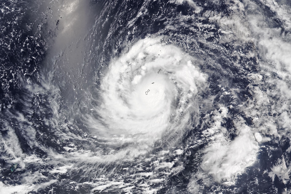
Photo courtesy of NASA Earth Observatory
MANILA — Metro Manila and nearby areas may experience rainy weather by early next week due to the southwest monsoon or habagat enhanced by super typhoon Mawar, PAGASA said Thursday.
Rains may be experienced the metropolitan areas as early as Monday, PAGASA weather specialist Ana Clauren-Jorda told ABS-CBN's TeleRadyo.
"Posible dito sa Metro Manila, early next week or by Monday posible rin pong makulimlim ang panahon at may mga pag-ulan din tayong mararanasan dala ng habagat," she said.
(It's possible that here in Metro Manila, we may experience cloudy weather with rains brought by the habagat early next week or by Monday.)
ADVERTISEMENT
This weekend, the enhanced southwest monsoon may also bring rains to southern Luzon and parts of Visayas and Mindanao, particularly Palawan, Occidental Mindoro, Western Visayas, Zamboanga Peninsula, and the Bangsamoro region.
Tropical cyclone wind signals may also be raised in parts of extreme northern Luzon in the coming days as Mawar nears the Philippine landmass, although it is not expected to make a direct hit anywhere in the country.
Mawar's rain bands may also bring heavy rains over Cagayan Valley from Sunday to Tuesday next week, with gale-force winds expected to be experienced in most area of the region.
Batanes and Babuyan Islands, meanwhile, may experience gale to storm-force conditions in the coming days.
In its latest bulletin issued 11 a.m. Thursday, PAGASA said it last located Mawar 2,065 kilometers east of southeastern Luzon.
It was packing maximum sustained winds of 185 kilometers per hour near the center with 230 kph gusts, and was moving westwards at a speed of 10 kph.
Mawar is forecast to enter the Philippine area of responsibility (PAR) by Friday evening or Saturday morning, and will move west northwestward towards the sea area east of extreme northern Luzon.
Once it enters the Philippine area of responsibility, it will be given the local name "Betty."
"Mawar is forecast to continue intensifying in the next three days and may reach a peak intensity of 215 kph by Sunday. Afterwards, the super typhoon is forecast to weaken although it will remain a typhoon by the end of the forecast period," the state weather bureau said.
For its part, the National Disaster Risk Reduction and Management Council (NDRRMC) said the government continues to prepare and monitor developments on Mawar.
NDRRMC spokesperson Raffy Alejandro said teams for evacuation and search-and-rescue operations have been in the Ilocos Region, Cagayan Valley, and the Cordillera Administrative Region have been activated and prepared.
Alejandro also said that the Department of Social Welfare and Development (DSWD) and the Office of Civil Defense (OCD) have also been preparing non-food items and other resources in anticipation of Mawar.
"Gusto nating mai-download in advance sa kanila iyong mga resources na dapat maibaba na bago lumapit itong bagyo. Although we still have 2 to 3 days to do that, but umpisa po ngayon—in fact kahapon pa po —ay puspusan na po ang paghahanda," he told ABS-CBN's TeleRadyo.
(We want to download their resources in advance before the cyclone nears. Although we still have 2 to 3 days to do that, we have been preparing since yesterday.)
The Philippine Coast Guard said it was on full alert and had advised shipping lines to consider seeking shelter or go to harbors ahead of the super typhoon's onslaught.
"Kasama din doon sa proactive na pag-deploy natin in advance. We have references kung saan madalas mangyari ang mga baha kung saka-sakali. Inatasan na rin natin ang ating mga units na before the rains come in, mayroon deployment in advance," Vice Admiral Rolando Punzalan, Jr. said in a public briefing.
ABS-CBN is the leading media and entertainment company in the Philippines, offering quality content across TV, radio, digital, and film. Committed to public service and promoting Filipino values, ABS-CBN continues to inspire and connect audiences worldwide.
Our website is made possible by displaying online
advertisements to our visitors. Please consider supporting
us by disabling your ad blocker on our website.
Our website is made possible by displaying online
advertisements to our visitors. Please consider supporting
us by disabling your ad blocker on our website.