Welcome, Kapamilya! We use cookies to improve your browsing experience. Continuing to use this site means you agree to our use of cookies. Tell me more!
Mawar slightly weakens to typhoon, but may reintensify: PAGASA
Mawar slightly weakens to typhoon, but may reintensify: PAGASA
Raffy Cabristante,
ABS-CBN News
Published May 24, 2023 01:23 PM PHT
|
Updated May 25, 2023 08:27 AM PHT
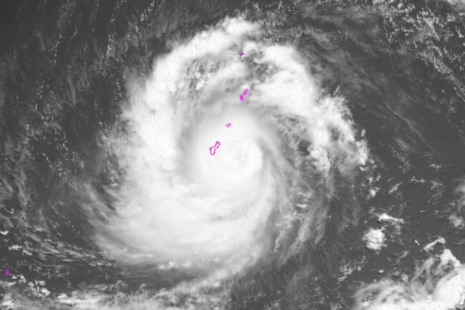
Typhoon Mawar hits Guam, a United States territory in the Pacific, on May 24, 2023. Satellite image courtesy of the US National Oceanic and Atmospheric Administration
Wind signals may be raised over parts of northern Luzon due to Mawar
MANILA (UPDATED) — Tropical cyclone Mawar slightly weakened to a typhoon from a supertyphoon on Wednesday, but could re-intensify once it enters the Philippine area, PAGASA said.
Mawar weakened due to the eyewall replacement cycle at around 8 a.m., PAGASA weather specialist Annaliza Clauren-Jorda said in a climate forum.
The typhoon may begin its approach into the Philippine area of responsibility (PAR) by Friday, May 26, and is expected to be inside PAR by Saturday, May 27, she said.
Once inside PAR, the cyclone will be given the local name "Betty."
ADVERTISEMENT
While Mawar has a low chance of making landfall anywhere in the Philippines, tropical cyclone wind signals may be raised over parts of Luzon, particularly its northern tip and Cagayan.
This is due to the storm's huge 320-kilometer radius, she said.
“Possibly by Sunday or Monday, may mga areas sa Northern Luzon na makaranas ng ulan. We’re also not ruling out the possiblity na baka magtaas ng warning signal,” PAGASA senior weather specialist Chris Perez said in a separate press conference Wednesday afternoon.
During its expected stay inside PAR, Mawar is forecast to enhance the southwest monsoon or habagat, which will bring rains to the country's western section, Palawan, and the entire Visayas this weekend.
“Kung magiging mabagal ang pagkilos nito once na malapit na sa area of Southern Taiwan or extreme Northern Luzon, posible itong mapagibayo ng habagat. Pag napagibayo ang habagat, asahan ang pagulan sa western portions of MIMAROPA, Visayas and Mindanao," Perez also said.
ADVERTISEMENT
Mawar was last spotted 2,170 kilometers east of Visayas, packing maximum sustained winds of 175 kilometers per hour near the center and 215 kph gusts. It was moving north-northwestward at 10 kph.
Luzon and Metro Manila are expected to experience generally fair weather on Thursday with thunderstorms in the afternoon or evening, Clauden-Jorda said.
Visayas and Mindanao are also advised to prepare for thunderstorms due to the prevailing southwesterly winds.
While the country continues to experience the dry season, PAGASA said it is still normal for the country to experience typhoons.
Super Typhoon Paeng in 2018 and Typhoon Urduja in 2013 both happened in the month of May where their origins are seen to be almost the same as Mawar's.
ADVERTISEMENT
Meanwhile, incoming PAGASA officer-in-charge Esperanza Cayanan noted that storm surges are not seen to occur based on current forecasts.
“Hindi naman tatama iyong bagyo. Malayo kasi. Usually ang storm surge, pag ito ay very close to the coastal areas or lalo na kung ito ay tatama sa kalupaan,” she said.
As Mawar enters PAR, PAGASA said it will be generating reports every six hours and will become more frequent as the cyclone heads closer to land.
ABS-CBN is the leading media and entertainment company in the Philippines, offering quality content across TV, radio, digital, and film. Committed to public service and promoting Filipino values, ABS-CBN continues to inspire and connect audiences worldwide.
Our website is made possible by displaying online
advertisements to our visitors. Please consider supporting
us by disabling your ad blocker on our website.
Our website is made possible by displaying online
advertisements to our visitors. Please consider supporting
us by disabling your ad blocker on our website.