Typhoon Bising keeps strength, to dump rains over Bicol, Quezon, N. Samar | ABS-CBN


ADVERTISEMENT

Welcome, Kapamilya! We use cookies to improve your browsing experience. Continuing to use this site means you agree to our use of cookies. Tell me more!
Typhoon Bising keeps strength, to dump rains over Bicol, Quezon, N. Samar
Typhoon Bising keeps strength, to dump rains over Bicol, Quezon, N. Samar
Gillan Ropero,
ABS-CBN News
Published Apr 20, 2021 11:54 AM PHT
|
Updated Apr 20, 2021 06:13 PM PHT
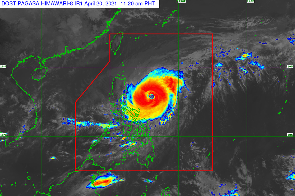
MANILA (UPDATE) —Typhoon Bising maintained its strength as it brushed past the eastern part of Luzon and Visayas on Tuesday but there is still a low chance of landfall, the state weather bureau said.
MANILA (UPDATE) —Typhoon Bising maintained its strength as it brushed past the eastern part of Luzon and Visayas on Tuesday but there is still a low chance of landfall, the state weather bureau said.
The country's second storm this year has left at least 2 dead in Eastern and Central Visayas regions and forced the evacuation of around 30,000 families in Eastern and Central Visayas and the Caraga region, according to the national disaster council.
The country's second storm this year has left at least 2 dead in Eastern and Central Visayas regions and forced the evacuation of around 30,000 families in Eastern and Central Visayas and the Caraga region, according to the national disaster council.
At least another 15,000 families were also evacuated in the Bicol region.
At least another 15,000 families were also evacuated in the Bicol region.
Bising (international name: Surigae) is forecast to bring light to moderate to at times heavy rains over the eastern portion of Quezon, Camarines provinces, and Catanduanes, PAGASA said in its 5 p.m. bulletin.
Bising (international name: Surigae) is forecast to bring light to moderate to at times heavy rains over the eastern portion of Quezon, Camarines provinces, and Catanduanes, PAGASA said in its 5 p.m. bulletin.
ADVERTISEMENT
It was last estimated 475 kilometers east of Baler town, Quezon as of 5 p.m., moving north northwest slowly while packing maximum sustained winds of 175 kms per hour near the center and gusts of up to 215 kph, according to the state weather bureau.
It was last estimated 475 kilometers east of Baler town, Quezon as of 5 p.m., moving north northwest slowly while packing maximum sustained winds of 175 kms per hour near the center and gusts of up to 215 kph, according to the state weather bureau.
There was no mention of a potential landfall in the latest PAGASA advisory.
There was no mention of a potential landfall in the latest PAGASA advisory.
Tropical cyclone wind signal no. 2 , which may tilt some wooden, old electric posts, was hoisted over the following areas:
Tropical cyclone wind signal no. 2 , which may tilt some wooden, old electric posts, was hoisted over the following areas:
- Eastern portion of Cagayan (Santa Ana, Gonzaga, Baggao, Gattaran, Lal-Lo, Peñablanca, Santa Teresita, Buguey, Camalaniugan, Aparri)
- Eastern portion of Isabela (San Pablo, Maconacon, Divilacan, Ilagan, Palanan, San Mariano, Dinapigue)
- Northern portion of Aurora (Dilasag), and Catanduanes
- Eastern portion of Cagayan (Santa Ana, Gonzaga, Baggao, Gattaran, Lal-Lo, Peñablanca, Santa Teresita, Buguey, Camalaniugan, Aparri)
- Eastern portion of Isabela (San Pablo, Maconacon, Divilacan, Ilagan, Palanan, San Mariano, Dinapigue)
- Northern portion of Aurora (Dilasag), and Catanduanes
The following areas were placed under [BOLD] tropical cyclone wind signal no. 1 [/BOLD], which may cause slight damage to some houses of very light materials or makeshift structures:
The following areas were placed under [BOLD] tropical cyclone wind signal no. 1 [/BOLD], which may cause slight damage to some houses of very light materials or makeshift structures:
- Batanes
- Rest of Cagayan including Babuyan Islands
- Rest of Isabela
- Quirino
- Apayao
- Kalinga
- Eastern portion of Mountain Province (Barlig, Natonin, Paracelis, Sadanga, Bontoc)
- Eastern portion of Ifugao (Banaue, Lagawe, Mayoyao, Aguinaldo, Alfonso Lista, Hingyon)
- Northern portion of Nueva Vizcaya (Diadi)
- Central portion of Aurora (Casiguran, Dinalungan, Dipaculao, Baler)
- Eastern portion of Quezon (Calauag, Guinayangan, Tagkawayan) including Polillo Islands
- Camarines Norte
- Camarines Sur
Bising is forecast to move north or north northwest until Wednesday evening and early Thursday, PAGASA said.
Bising is forecast to move north or north northwest until Wednesday evening and early Thursday, PAGASA said.
It will then move northeastward from the landmass of Luzon throughout Thursday and east northeastward on Friday and Saturday before it exits the Philippine Area of Responsibility on Sunday.
It will then move northeastward from the landmass of Luzon throughout Thursday and east northeastward on Friday and Saturday before it exits the Philippine Area of Responsibility on Sunday.
ADVERTISEMENT
ADVERTISEMENT