Welcome, Kapamilya! We use cookies to improve your browsing experience. Continuing to use this site means you agree to our use of cookies. Tell me more!
Heavy rains, storm signals up due to tropical depression Kabayan
Heavy rains, storm signals up due to tropical depression Kabayan
ABS-CBN News
Published Dec 17, 2023 08:18 AM PHT
|
Updated Dec 17, 2023 12:34 PM PHT
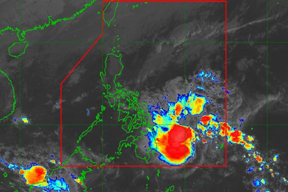
PAGASA photo
MANILA (2nd UPDATE) — State weather bureau PAGASA on Sunday warned of heavy rains and placed many areas under Signal Number 1, as the low-pressure area (LPA) off Mindanao developed into tropical depression Kabayan.
Kabayan, last located 440 kilometers east of Davao City, Davao del Sur, is packing 55 kilometers per hour winds and gustiness of up to 70 kph, according to PAGASA's 11 a.m. bulletin.
It is moving north-northwestward slowly.
The weather agency warned of heavy rainfall from Sunday until early next week in Mindanao and some Visayas provinces due to Kabayan.
ADVERTISEMENT
SUNDAY
100-200 mm: Surigao del Sur, Surigao del Norte, Dinagat Islands, and Southern Leyte
50-100 mm: Eastern Visayas, Davao Region, Northern Mindanao, and the rest of Caraga
MONDAY
100-200 mm: Surigao del Sur, Surigao del Norte, Dinagat Islands, and Southern Leyte
50-100 mm: Eastern Visayas, Central Visayas, Northern Mindanao, and the rest of Caraga.
The eastern portion of Southern Luzon could also experience heavy rainfall on Sunday, and rains could arrive in the eastern portion of Luzon by Monday due to the shear line coinciding with the passage of Kabayan, PAGASA also said.
"Under these conditions, flooding and rain-induced landslides are likely," it warned.
PAGASA raised Signal No. 1 over the following areas, where minimal to minor impacts from strong winds are possible.
VISAYAS
The southern portion of Samar (Basey, Santa Rita, Marabut, Talalora, Villareal, Pinabacdao)
The southern portion of Eastern Samar (Maydolong, City of Borongan, Quinapondan, Guiuan, Lawaan, Balangiga, Llorente, Giporlos, Salcedo, Balangkayan, General Macarthur, Hernani, Mercedes)
Leyte
Southern Leyte
Bohol
Camotes Islands
MINDANAO
Dinagat Islands
Surigao del Norte
Surigao del Sur
Agusan del Norte
Agusan del Sur
The northern portion of Davao Oriental (Cateel, Boston, Baganga)
The northern portion of Davao de Oro (Monkayo, Laak)
Misamis Oriental
Camiguin
The northern portion of Bukidnon (Impasug-Ong, Malitbog, Manolo Fortich, Sumilao, Libona, Baungon, Cabanglasan, City of Malaybalay)
A gale warning is in effect for the coastal waters along the seaboard of Northern Luzon and the eastern seaboards of Visayas and Mindanao, PAGASA said.
It cautioned that sea travel is risky for small seacrafts, including all motor bancas, adding that mariners of these vessels are advised to remain in port or seek safe harbor.
Coast Guard District Central Visayas meanwhile released a notice to mariners suspending sailing in its area of responsibility.
PAGASA photo
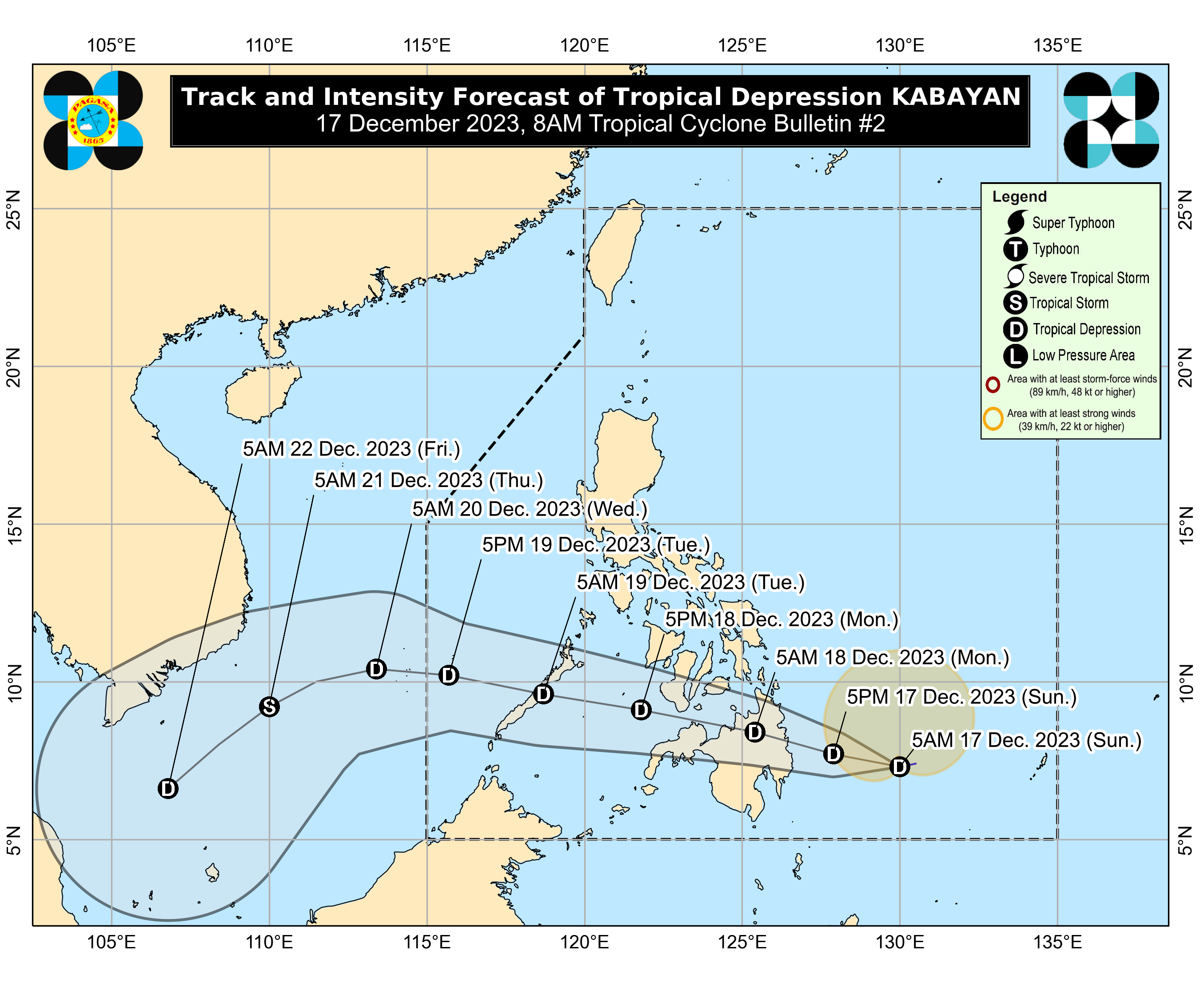
INTENSITY AND TRACK PREDICTION
PAGASA forecast that Kabayan would maintain its strength until its initial landfall along the coast of Surigao del Sur or Davao Oriental on Sunday night or Monday early morning.
It will cross the rugged terrain of Mindanao before emerging over either the Bohol Sea or Sulu Sea on Monday morning or afternoon, it said.
The weather bureau said the storm could weaken into an LPA over land or after emerging over the sea because of the "frictional effects" of landfall.
PAGASA however noted that the cyclone may reintensify over the Sulu Sea.
Kabayan is forecast to hit land for the second time over central or southern Palawan as a tropical depression by Tuesday morning, it said.
ABS-CBN is the leading media and entertainment company in the Philippines, offering quality content across TV, radio, digital, and film. Committed to public service and promoting Filipino values, ABS-CBN continues to inspire and connect audiences worldwide.
Our website is made possible by displaying online
advertisements to our visitors. Please consider supporting
us by disabling your ad blocker on our website.
Our website is made possible by displaying online
advertisements to our visitors. Please consider supporting
us by disabling your ad blocker on our website.