Welcome, Kapamilya! We use cookies to improve your browsing experience. Continuing to use this site means you agree to our use of cookies. Tell me more!
Typhoon Odette intensifies as it nears CARAGA region
Typhoon Odette intensifies as it nears CARAGA region
ABS-CBN News
Published Dec 15, 2021 06:59 PM PHT
|
Updated Dec 15, 2021 09:43 PM PHT
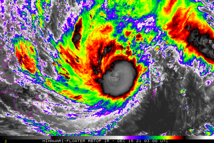
MANILA - Typhoon Odette (international name Rai) intensified further on Wednesday as it approached the CARAGA region, state weather bureau PAGASA said.
According to PAGASA, Odette was last spotted 485 kilometers east of Hinatuan, Surigao del Sur at 4:00 p.m. It was packing maximum sustained winds of up to 130 kilometers per hour and gusts of up to 160kph. The typhoon was moving west northwestward at 25 km/h.
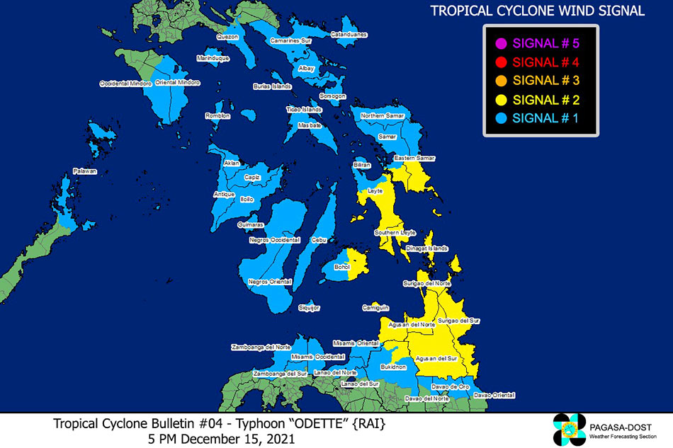
More areas were placed under Tropical Cyclone Wind Signals (TCWS) due to Odette.
Areas under Tropical Cyclone Wind Signal number 2:
ADVERTISEMENT
Surigao del Norte
Surigao del Sur
Dinagat Islands
Agusan del Sur
Agusan del Norte
Northeastern portion of Bukidnon
Eastern portion of Misamis Oriental
Camiguin
Southern portion of Eastern Samar
Southern portion of Samar
Southern Leyte
Central and southern portions of Leyte
Camotes Islands
Eastern portion of Bohol
"In the next 24 hours po makakaranas ng malalakas na hangin diyan, yung pwedeng maka-damage sa mga puno at maka-inflict din ng konting damage sa mga bahay na gawa sa light materials," ABS-CBN weather specialist Ariel Rojas said on TeleRadyo.
(In the next 24 hours, these places will experience strong winds that can damage trees and homes made out of light materials.)
Areas under Tropical Cyclone Wind Signal number 1:
Northern portion of Davao Oriental
Northern portion of Davao de Oro
Northern portion of Davao del Norte
Northwestern and central portions of Bukidnon City
Rest of Misamis Oriental
Misamis Occidental
Northern portion of Lanao del Norte
Northern portion of Zamboanga del Sur
Northwestern portion of Zamboanga del Norte
Northern portion of Lanao del Sur
Northern Samar
Rest of Eastern Samar
Biliran
Rest of Leyte
Rest of Bohol
Cebu
Siquijor
Negros Oriental
Negros Occidental
Guimaras
Iloilo
Antique
Capiz
Aklan
Catanduanes
Camarines Sur
Albay
Masbate including Ticao and Burias Islands
Southern portion of Quezon
Marinduque
Romblon
Central and southern portions of Oriental Mindoro
Central and southern portions of Occidental Mindoro
Northern portion of Palawan
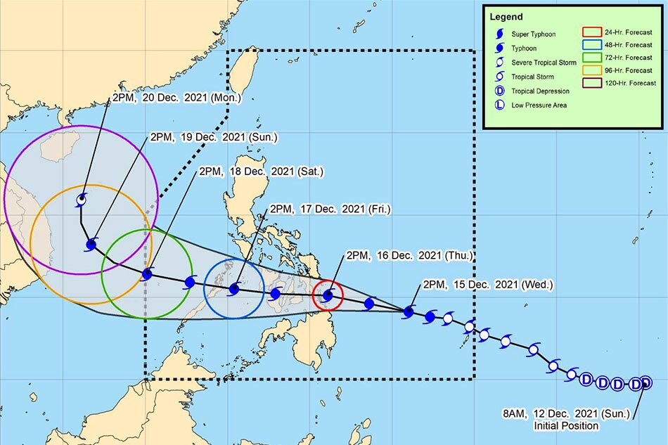
Projected track of Typhoon Odette. PAGASA
"Yung mga bagong dagdag sa listahan ng signal number 1, may 36 hours pa pong lead time bago maramdaman yung pagbugso ng hangin," Rojas said.
(Areas recently placed under signal number 1 have a 36-hour lead time before they experience stronger winds.)
PAGASA also warned of potential 2-meter-high storm surges in coastal areas in the Visayas, CARAGA, Northern Mindanao, Palawan, and Masbate.
Rojas said Odette was expected to reach a peak intensity of 155kph before making landfall over either CARAGA or Eastern Visayas on Thursday.
The typhoon may then go across the Visayas and reach the Sulu Sea by Friday morning, before leaving the Philippine Area of Responsibility by Saturday.
The Department of the Interior and Local Government (DILG) has placed the following areas under its own typhoon alert level:
Areas under Alert Level Charlie (155kph winds with intense to torrential rains)
Palawan
Antique
Negros Occidental
Bohol
Cebu
Southern Leyte
Guimaras
Dinagat Islands
Capiz
Leyte
Negros Oriental
Iloilo
Eastern Samar
Siquijor
Surigao del Norte
Agusan del Norte
Agusan del Sur
Surigao del Sur
Camiguin
Areas under Alert Level Bravo (Up to 120kph winds with heavy to intense with at times torrential rains)
Misamis Oriental
Zamboanga del Norte
Occidental Mindoro
Aklan
Masbate
Samar
Biliran
Romblon
Northern Samar
Oriental Mindoro
Areas under Alert Level Alpha (Up to 60kph winds with light to moderate with at times heavy rains)
Misamis Occidental
Zamboanga del Sur
Lanao del Sur
Davao de Oro
Zamboanga Sibugay
Davao Oriental
Davao del Norte
Bukidnon
Lanao del Norte
Quezon
Albay
Sorsogon
Marinduque
Cavite
Catanduanes
Batangas
Camarines Sur
Laguna
In Metro Manila, Rojas said residents can still attend Misa de Gallo or "Simbang Gabi" early Thursday without worrying about bad weather.
"Pero yung Friday or Thursday night or Friday or Saturday early morning po, yun po yung possibleng may ulan tayo sa Metro Manila so magdala na lang po ng payong para sa mga magsisimba," he said.
(But on Friday or Thursday night, or Friday or Saturday early morning, those are the times when we may see rain over Metro Manila, so churchgoers should bring umbrellas.)
ABS-CBN is the leading media and entertainment company in the Philippines, offering quality content across TV, radio, digital, and film. Committed to public service and promoting Filipino values, ABS-CBN continues to inspire and connect audiences worldwide.
Our website is made possible by displaying online
advertisements to our visitors. Please consider supporting
us by disabling your ad blocker on our website.
Our website is made possible by displaying online
advertisements to our visitors. Please consider supporting
us by disabling your ad blocker on our website.