Welcome, Kapamilya! We use cookies to improve your browsing experience. Continuing to use this site means you agree to our use of cookies. Tell me more!
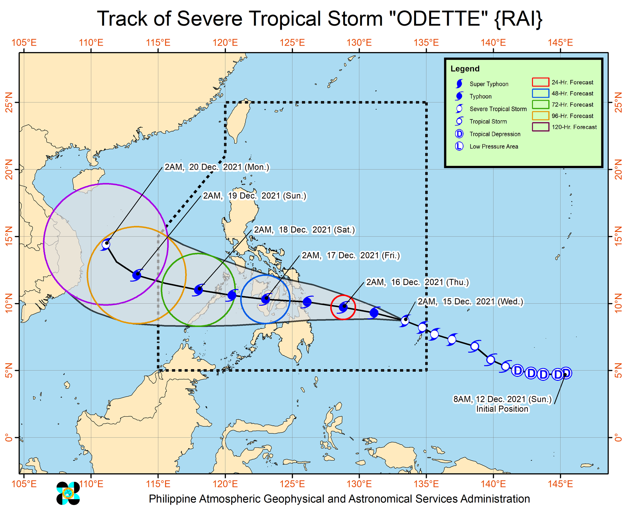
(UPDATE) The strength of severe tropical storm Odette is nearing typhoon category, PAGASA said in its early Wednesday morning bulletin.
Odette was last estimated to be at 735 kilometers east of Hinatuan town, Surigao del Sur, packing maximum sustained winds of 110 kilometers per hour near the center, with gusts of up to 135 kph.
It is moving west northwestward at 25 kph, with strong winds extending outwards up to 330 km from the center.
The development meant more provinces were put under Signal No. 1, including the following:
ADVERTISEMENT
Northern Samar
Eastern Samar
Samar
Biliran
Leyte
Southern Leyte
Bohol
Northern and central portions of Cebu (Daanbantayan, Medellin, City of Bogo, San Remigio, Tabogon, Borbon, Sogod, Catmon, Carmen, Danao City, Compostela, Liloan, Tabuelan, Tuburan, Asturias, City of Carcar, Pinamungahan, San Fernando, Toledo City, City of Naga, Balamban, Minglanilla, Cebu City, City of Talisay, Consolacion, Mandaue City, Lapu-Lapu City, Cordova) including Bantayan and Camotes Islands
From Wednesday to Thursday morning, light to moderate with at times heavy rains are possible over Surigao del Norte, Surigao del Sur, and Dinagat Islands due to the trough and the outermost rain bands of Odette.
From Thursday to Friday, heavy to intense with at times torrential rains may prevail over Dinagat Islands, Surigao del Norte, the northern portion of Surigao del Sur, Agusan del Norte, the northern portion of Agusan del Sur, Camiguin, Misamis Oriental, Southern Leyte, Bohol, Negros Oriental, and Cebu, while moderate to heavy with at times intense rains may be experienced over Leyte, the southern portion of Eastern Samar, Siquijor, and the rest of Caraga.
Light to moderate with at times heavy rains are also expected over Bicol Region, Zamboanga del Norte, Oriental Mindoro, Romblon, and the rest of Visayas and Northern Mindanao.
PAGASA warned that under these conditions, scattered to widespread flooding (including flash floods) and rain-induced landslides are expected especially in areas that are highly or very highly susceptible to these hazard as identified in hazard maps, and in localities with significant antecedent rainfall.
PAGASA
Odette is expected to make landfall over the vicinity of Caraga or Eastern Visayas Thursday afternoon or evening.
It is also expected to further intensify within 12 hours and may reach peak intensity of 155 kph before making landfall.
PAGASA added it expected up to 2 more storms to enter the PAR before the year ends
ABS-CBN is the leading media and entertainment company in the Philippines, offering quality content across TV, radio, digital, and film. Committed to public service and promoting Filipino values, ABS-CBN continues to inspire and connect audiences worldwide.
Our website is made possible by displaying online
advertisements to our visitors. Please consider supporting
us by disabling your ad blocker on our website.
Our website is made possible by displaying online
advertisements to our visitors. Please consider supporting
us by disabling your ad blocker on our website.