Welcome, Kapamilya! We use cookies to improve your browsing experience. Continuing to use this site means you agree to our use of cookies. Tell me more!
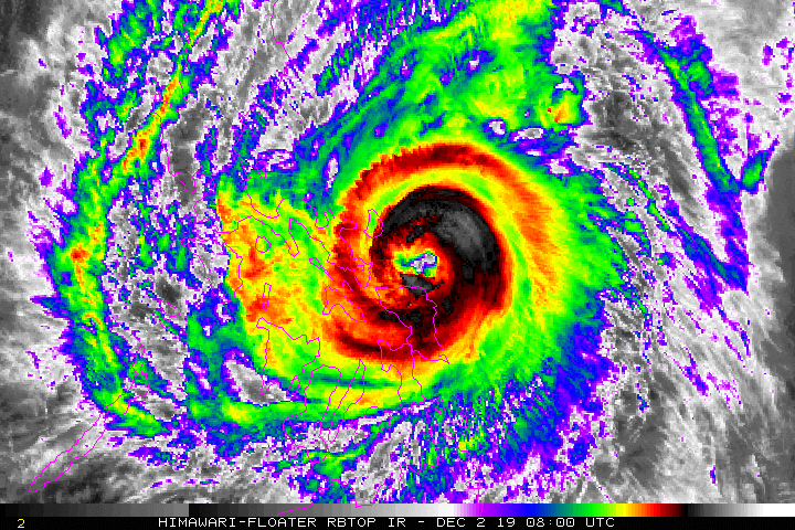
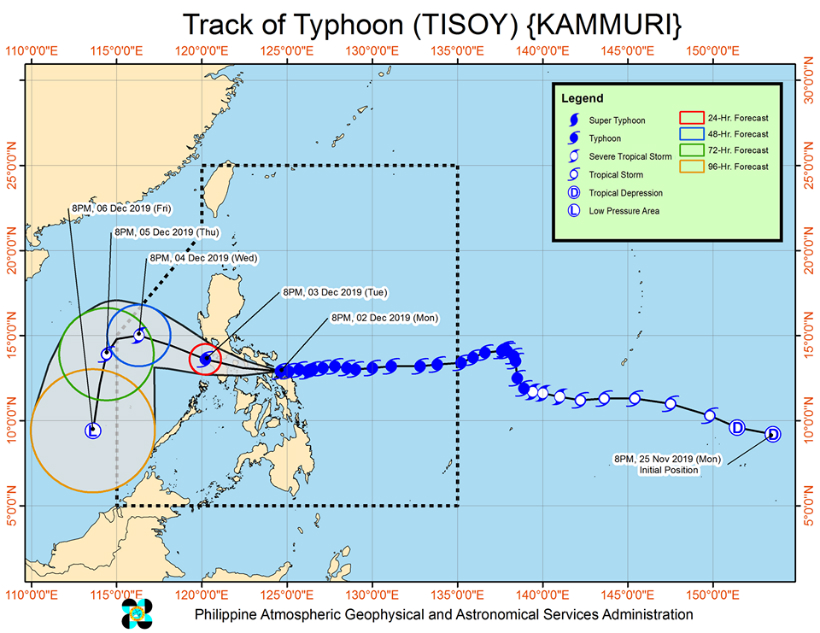
MANILA (2nd UPDATE)—Typhoon Tisoy (international name Kammuri) intensified further as it made landfall over Sorsogon Monday night, state weather bureau PAGASA said.
The eye of the typhoon made landfall over Gubat town in Sorsogon at 11 p.m. It was next spotted over Pilar town at 1 a.m.
Tisoy slightly weakened following its landfall and is now packing maximum sustained winds of up to 165 kilometers per hour (kph) and 275 kph gusts, PAGASA said in its 2 a.m. bulletin.
The typhoon's eyewall is currently bringing violent winds and intense rains over Northern Samar, Catanduanes, Albay, Camarines Sur and Sorsogon, the agency added.
ADVERTISEMENT
Camarines Norte and Masbate will also be affected by the eyewall in the next 3 hours.
PAGASA image
Frequent to continuous heavy to intense rains will lash Bicol Region, Northern Samar, Southern Quezon, Marinduque, and Romblon until Tuesday afternoon.
Samar, Eastern Samar, Rizal, rest of Quezon, Laguna and Oriental Mindoro will experience occasional to frequent heavy rains while Metro Manila, Occidental Mindoro, the rest of Calabarzon, Aurora, the rest of Eastern Visayas and the eastern portions of Cagayan and Isabela will get occasional to frequent heavy rains, PAGASA said.
Between Tuesday afternoon and Wednesday morning, frequent to continuous heavy to intense rains will lash Calabarzon, Central Luzon, Metro Manila, Mindoro Provinces, Marinduque and Romblon.
Occasional to frequent heavy rains will be experienced over Cagayan Valley, Cordillera Administrative Region and Calamian Islands while Aklan, Capiz and northern Antique intermittent heavy rains.
Storm surges of up to 3 meters (10 feet) may hit coastal areas in Catanduanes, Northern Samar, the northern and eastern coast of Camarines Sur, the eastern coast of Albay, and the eastern and southern coast of Sorsogon.
Coastal areas in Batangas, Quezon, Marinduque, Oriental Mindoro, Occidental Mindoro, and the remaining coastal areas of Camarines Sur, Albay and Sorsogon may also experienced huge waves.
"Within 24 hours ay makakaranas ng malakas na ulan, ganun din ang malakas na hangin dito sa Southern Luzon, kasama ang Metro Manila, ganoon din sa ilang bahagi ng Central Luzon, at ganoon din sa may Eastern Visayas, sa may northern portion ng Central Visayas at ganoon din sa may Panay island," PAGASA weather forecaster Aldczar Aurelio said.
The weather agency also hoisted storm signal 3 over the following areas, which may be whipped by 121 to 170 kph winds:
Catanduanes
Camarines Sur
Albay
Sorsogon
Camarines Norte
Masbate including Ticao and Burias Islands
Romblon
southern portion of Quezon (Perez, Alabat, Quezon, Atimonan, Padre Burgos, Agdangan, Plaridel, Unisan, Pitogo, Gumaca, Lopez, Macalelon, General Luna, Calauag, Guinayangan, Tagkawayan, Buenavista, Mulanay, San Narciso, San Francisco, San Andres)
Marinduque
Oriental Mindoro
Occidental Mindoro including Lubang Island
Batangas
Cavite
Laguna
Northern Samar
northern portion of Eastern Samar (Can-avid, Dolores, Maslog, Oras, Arteche, Jipapad, San Policarpio)
northern portion of Samar (Catbalogan, Jiabong, Motiong, Paranas, San Jose de Buan, San Jorge, Pagsanghan, Tarangnan, Sta. Margarita, Gandara, Matuguinao, Calbayog, Tagapul-an, Almagro, Sto. Niño)
The following areas, which may be battered by 61-120 kph winds, are under Signal no. 2:
Metro Manila
Bulacan
Bataan
Tarlac
Pampanga
Nueva Ecija
southern Aurora (Dipaculao, Maria Aurora, Baler, San Luis, Dingalan)
Rizal
rest of Quezon including Polillo Islands
Calamian Islands
Cuyo Islands (Cuyo, Magsaysay, Agutaya)
Zambales
Pangasinan
rest of Eastern Samar
rest of Samar
Biliran
Aklan
Capiz
Antique
Iloilo
Guimaras
northern portion of Negros Occidental ( Talisay, Calatrava, Silay, Enrique B. Magalona, Victorias, Manapla, Cadiz, Sagay, Escalante, Toboso, Bacolod, Murcia, Salvador Benedicto, San Carlos, Bago, Pulupandan, Valladolid, La Carlota, San Enrique, Pontevedra, La Castellana, Moises Padilla)
northern Cebu (Daanbantayan, Bantayan, Madridejos, Santa Fe, Medellin, Bogo City, San Remigio, Tabogon, Tabuelan, Tuburan, Carmen Borbon, Sogod, Catmon, Asturias, and Camotes Islands)
Leyte
Of these areas, Metro Manila, Pampanga, Laguna, Cavite and Batangas are home to several venues of the 30th SEA Games.
Meanwhile, the following areas were placed under signal no. 1, which means these may be lashed by 30 to 60 kph winds in 36 hours.
Southern Isabela (Palanan, Dinapique, San Mariano, San Guillermo, Benito Soliven, Naguilian, Reina Mercedes, Luna, Aurora, Cabatuan, San Mateo, Cauayan City, Alicia, Angadanan, Ramon, San Isidro, Echague, Cordon, Santiago City, Jones and San Agustin)
Mountain Province
Ifugao
Benguet
Nueva Vizcaya
Ilocos Sur
La Union
Quirino
rest of Aurora
northern portion of Palawan (Taytay, Araceli, Dumaran, San Vicente, Roxas)
rest of Negros Occidental
Negros Oriental
Bohol
Siquijor
rest of Cebu
rest of Leyte
Southern Leyte
Dinagat Islands
Siargao Island
Typhoon Tisoy has prompted the cancellation of airline flights and classes in some areas.
ABS-CBN is the leading media and entertainment company in the Philippines, offering quality content across TV, radio, digital, and film. Committed to public service and promoting Filipino values, ABS-CBN continues to inspire and connect audiences worldwide.
Our website is made possible by displaying online
advertisements to our visitors. Please consider supporting
us by disabling your ad blocker on our website.
Our website is made possible by displaying online
advertisements to our visitors. Please consider supporting
us by disabling your ad blocker on our website.