Typhoon Ramon almost stationary, landfall seen by Monday: PAGASA | ABS-CBN


ADVERTISEMENT

Welcome, Kapamilya! We use cookies to improve your browsing experience. Continuing to use this site means you agree to our use of cookies. Tell me more!
Typhoon Ramon almost stationary, landfall seen by Monday: PAGASA
Typhoon Ramon almost stationary, landfall seen by Monday: PAGASA
ABS-CBN News
Published Nov 16, 2019 03:44 PM PHT
|
Updated Nov 16, 2019 06:16 PM PHT
MANILA - Tropical storm Ramon is expected to make landfall over the municipality of Santa Ana in Cagayan by Monday, weather bureau PAGASA said on Saturday.
MANILA - Tropical storm Ramon is expected to make landfall over the municipality of Santa Ana in Cagayan by Monday, weather bureau PAGASA said on Saturday.
"By Monday morning, ito'y tinatayang malapit na sa Cagayan area. Base sa ating forecast track, dito nga siya sa bahagi ng Santa Ana, Cagayan posibleng tumama," said Weather Specialist Raymond Ordinario.
"By Monday morning, ito'y tinatayang malapit na sa Cagayan area. Base sa ating forecast track, dito nga siya sa bahagi ng Santa Ana, Cagayan posibleng tumama," said Weather Specialist Raymond Ordinario.
(By Monday morning, it is expected to move closer to Cagayan area. Based on our forecast track, it is expected to make landfall in Santa Ana, Cagayan.)
(By Monday morning, it is expected to move closer to Cagayan area. Based on our forecast track, it is expected to make landfall in Santa Ana, Cagayan.)
As of the 11 a.m. bulletin, Ordinario said the center of Ramon was located 420 kilometers north northeast of Virac, Catanduanes, packing maximum sustained winds of 65 kilometers per hour near the center and gustiness of up to 80 kph.
As of the 11 a.m. bulletin, Ordinario said the center of Ramon was located 420 kilometers north northeast of Virac, Catanduanes, packing maximum sustained winds of 65 kilometers per hour near the center and gustiness of up to 80 kph.
ADVERTISEMENT
Currently, Ramon remains almost stationary, he said.
Currently, Ramon remains almost stationary, he said.
"Mula kagabi hanggang ngayong umaga halos hindi siya gumagalaw sa kaniyang lokasyon. Halos hindi siya kumikilos," he said.
"Mula kagabi hanggang ngayong umaga halos hindi siya gumagalaw sa kaniyang lokasyon. Halos hindi siya kumikilos," he said.
(Since last night until this morning it almost hasn't moved from its location. It's almost stationary.)
(Since last night until this morning it almost hasn't moved from its location. It's almost stationary.)
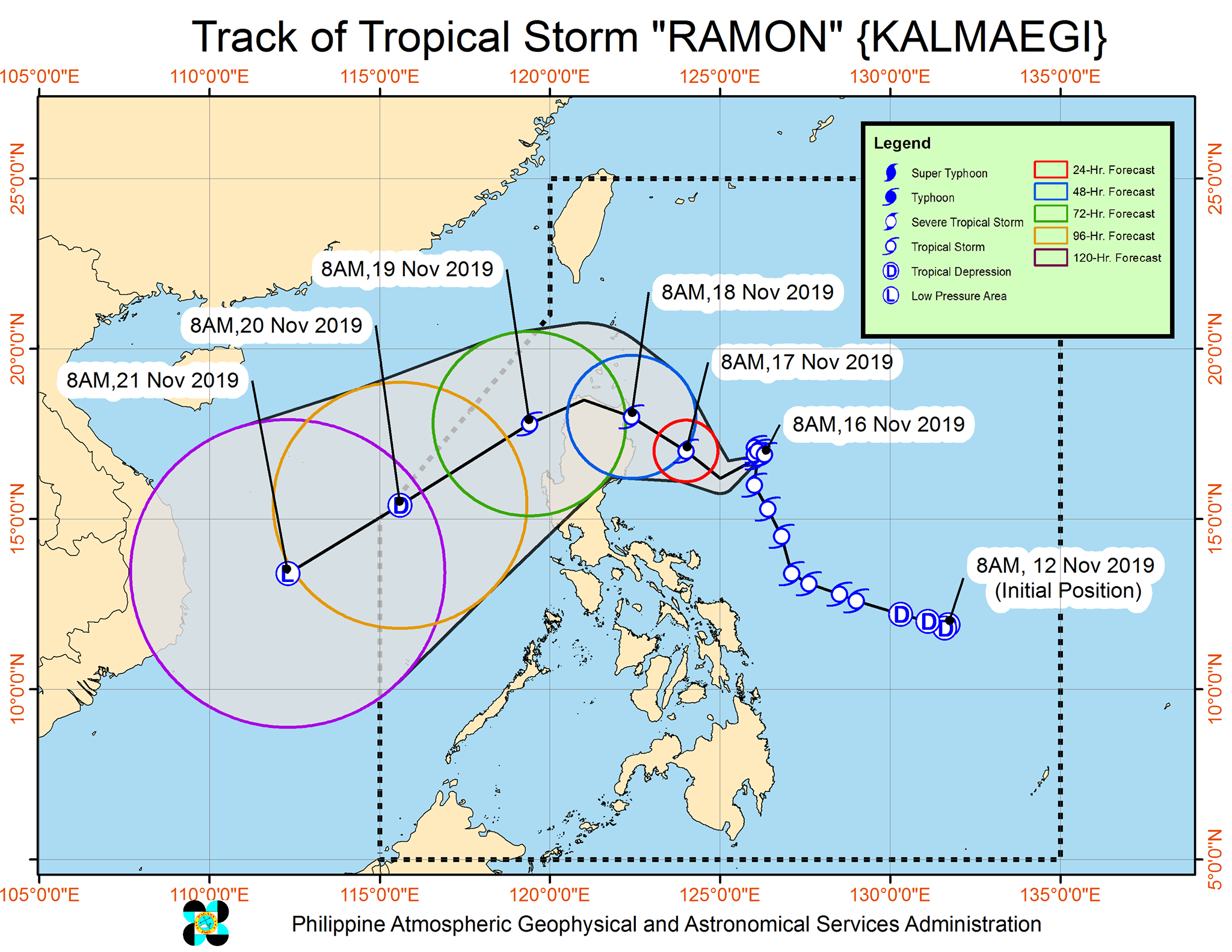
Tropical cyclone wind signal number 1 remains hoisted over the eastern portions of Cagayan and Isabela, and the northern portion of Aurora.
Tropical cyclone wind signal number 1 remains hoisted over the eastern portions of Cagayan and Isabela, and the northern portion of Aurora.
"Base sa forecast track natin, kung dito nga babaybay ang ating bagyo, starting tomorrow posible na tayong magtaas ng signal dito sa extreme part of Northern Luzon at Ilocos Norte. Ito'y dedepende kung tuluyan na itong kikilos starting tomorrow," said Ordinario.
"Base sa forecast track natin, kung dito nga babaybay ang ating bagyo, starting tomorrow posible na tayong magtaas ng signal dito sa extreme part of Northern Luzon at Ilocos Norte. Ito'y dedepende kung tuluyan na itong kikilos starting tomorrow," said Ordinario.
(Based on our forecast track, it's possible that we will raise storm signals in the extreme part of Northern Luzon and Ilocos Norte by tomorrow. This would depend if the typhoon would finally start moving by tomorrow.)
(Based on our forecast track, it's possible that we will raise storm signals in the extreme part of Northern Luzon and Ilocos Norte by tomorrow. This would depend if the typhoon would finally start moving by tomorrow.)
Ramon is expected to bring light to moderate with intermittent heavy rains over the eastern portion of Cagayan, Isabela, Bicol Region, Northern Samar and Romblon on Saturday.
Ramon is expected to bring light to moderate with intermittent heavy rains over the eastern portion of Cagayan, Isabela, Bicol Region, Northern Samar and Romblon on Saturday.
By Sunday, the eastern portion of Cagayan and Isabela is expected to have light to moderate with occasional heavy rains while light to moderate with intermittent heavy rains may be experienced in Apayao, Kalinga, Northern Aurora and the rest of Cagayan and Isabela.
By Sunday, the eastern portion of Cagayan and Isabela is expected to have light to moderate with occasional heavy rains while light to moderate with intermittent heavy rains may be experienced in Apayao, Kalinga, Northern Aurora and the rest of Cagayan and Isabela.
Ordinario said Ramon could weaken to a low pressure area as it exits the Philippine area of responsibility (PAR) by Thursday.
"Halos four days pa siyang magbabaybay dito sa ating Philippine Area of Responsibility," he said.
Ordinario said Ramon could weaken to a low pressure area as it exits the Philippine area of responsibility (PAR) by Thursday.
"Halos four days pa siyang magbabaybay dito sa ating Philippine Area of Responsibility," he said.
(It will remain in the Philippine Area of Responsibility for about four days.)
(It will remain in the Philippine Area of Responsibility for about four days.)
Gale warning is still up over the following areas:
Gale warning is still up over the following areas:
- Ilocos Norte
- Ilocos Sur
- La Union
- Pangasinan
- Batanes
- Calayan
- Babuyan Islands
- Aurora
- Quezon including Polillo Island
- Camarines Provinces
- Catanduanes
- Eastern coast of Albay
- Eastern coast of Sorsogon
- Ilocos Norte
- Ilocos Sur
- La Union
- Pangasinan
- Batanes
- Calayan
- Babuyan Islands
- Aurora
- Quezon including Polillo Island
- Camarines Provinces
- Catanduanes
- Eastern coast of Albay
- Eastern coast of Sorsogon
Meanwhile, the other typhoon being monitored by Pagasa is now moving away from PAR.
Meanwhile, the other typhoon being monitored by Pagasa is now moving away from PAR.
Visit the ABS-CBN Weather Center for more updates.
ADVERTISEMENT
ADVERTISEMENT