Typhoon Rolly makes fourth landfall over Batangas | ABS-CBN
ADVERTISEMENT

Welcome, Kapamilya! We use cookies to improve your browsing experience. Continuing to use this site means you agree to our use of cookies. Tell me more!
News
Typhoon Rolly makes fourth landfall over Batangas
Typhoon Rolly makes fourth landfall over Batangas
ABS-CBN News
Published Nov 01, 2020 06:04 PM PHT
|
Updated Nov 01, 2020 07:16 PM PHT
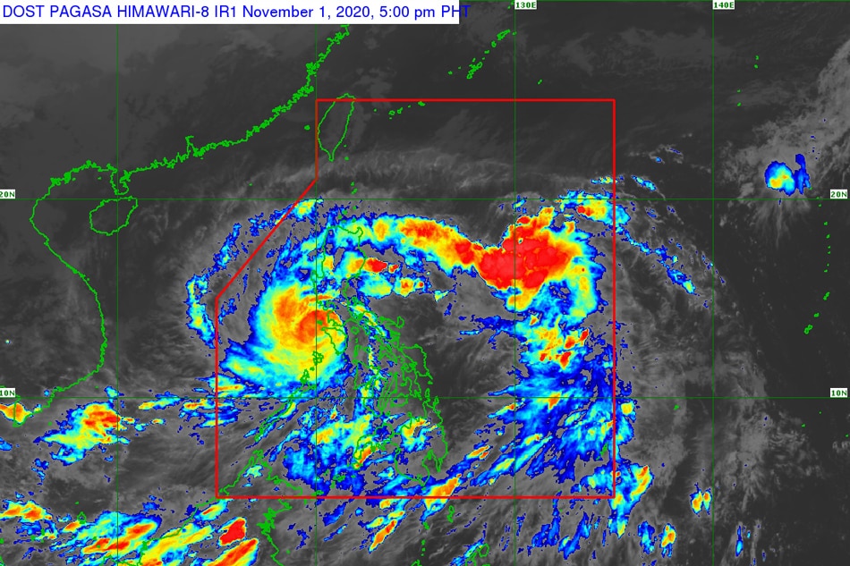
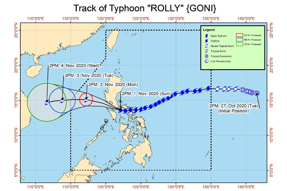
MANILA (UPDATE) - Typhoon Rolly made its fourth landfall in the vicinity of Lobo, Batangas on Sunday afternoon, the state weather bureau said Sunday.
MANILA (UPDATE) - Typhoon Rolly made its fourth landfall in the vicinity of Lobo, Batangas on Sunday afternoon, the state weather bureau said Sunday.
Rolly made its fourth landfall at 5:30 p.m. Sunday, PAGASA weather forecaster Lorie dela Cruz told ABS-CBN Teleradyo.
Rolly made its fourth landfall at 5:30 p.m. Sunday, PAGASA weather forecaster Lorie dela Cruz told ABS-CBN Teleradyo.
The typhoon first made landfall in Bato, Catanduanes early Sunday, before making its second landfall in Tiwi, Albay at 7:20 a.m.
The typhoon first made landfall in Bato, Catanduanes early Sunday, before making its second landfall in Tiwi, Albay at 7:20 a.m.
Rolly made its third landfall in the vicinity of San Narciso, Quezon on Sunday noon.
Rolly made its third landfall in the vicinity of San Narciso, Quezon on Sunday noon.
ADVERTISEMENT
PAGASA, in its 5 p.m. weather bulletin, said Rolly is forecast to traverse the Batangas-Cavite area, and the center of the eye of the storm is estimated to be around 70 km south of Metro Manila between 5 p.m. to 7 p.m.
PAGASA, in its 5 p.m. weather bulletin, said Rolly is forecast to traverse the Batangas-Cavite area, and the center of the eye of the storm is estimated to be around 70 km south of Metro Manila between 5 p.m. to 7 p.m.
The world's strongest storm so far this year was last estimated 50 kms south southwest of Tayabas Quezon, moving west at 25 km per hour with maximum winds of 165 kph near the center and gusts of up to 230 kph.
The world's strongest storm so far this year was last estimated 50 kms south southwest of Tayabas Quezon, moving west at 25 km per hour with maximum winds of 165 kph near the center and gusts of up to 230 kph.
Metro Manila and other provinces north and south of it remain under tropical cyclone warning signal no. 3, according to PAGASA.
Metro Manila and other provinces north and south of it remain under tropical cyclone warning signal no. 3, according to PAGASA.
The following areas were placed under tropical cyclone warning signal no. 3, where 121-170 kph winds were expected within 18 hours and may uproot trees and cause moderate to heavy damage:
The following areas were placed under tropical cyclone warning signal no. 3, where 121-170 kph winds were expected within 18 hours and may uproot trees and cause moderate to heavy damage:
- Metro Manila
- the southern portion of Zambales (San Marcelino, San Narciso, Subic, Olongapo City, Castillejos, San Antonio)
- Bataan
- the southern portion of Pampanga (Floridablanca, Guagua, Minalin, Apalit, Macabebe, Masantol, Sasmuan, Lubao)
- the southern portion of Bulacan (Baliuag, Bustos, Angat, Norzagaray, San Jose del Monte City, Santa Maria, Pandi, Plaridel, Pulilan, Calumpit, Malolos City, Guiguinto, Balagtas, Bocaue, Marilao, Meycauayan City, Obando, Bulacan, Paombong, Hagonoy)
- Rizal
- Quezon including Polillo Islands
- Cavite
- Laguna
- Batangas
- Marinduque
- the northwestern portion of Occidental Mindoro (Santa Cruz, Mamburao, Paluan, Abra de Ilog) including Lubang Island
- the northern portion of Oriental Mindoro (Puerto Galera, San Teodoro, Baco, Calapan City, Naujan, Victoria, Naujan Lake, Pola, Socorro)
The following areas are under signal no.2, where 61-120 kph winds were expected within 24 hours and may damage wooden and old electric posts:
The following areas are under signal no.2, where 61-120 kph winds were expected within 24 hours and may damage wooden and old electric posts:
- the rest of Zambales
- the rest of Pampanga
- the rest of Bulacan
- the southern portion of Tarlac (Concepcion, Capas, Bamban)
- the rest of Occidental Mindoro
- the rest of Oriental Mindoro
- the southern portion of Nueva Ecija (General Tinio, Gapan City, Peñaranda, San Leonardo, Jaen, San Isidro, Cabiao, San Antonio)
Signal no. 1 is hoisted over the following areas, where 30-60 kph winds may rip roofs off nipa and cogon huts, damage rice crops and down banana plants:
Signal no. 1 is hoisted over the following areas, where 30-60 kph winds may rip roofs off nipa and cogon huts, damage rice crops and down banana plants:
- Mainland Cagayan
- Isabela
- Apayao
- Kalinga
- Mountain Province
- Ifugao
- Abra
- Ilocos Norte
- Ilocos Sur
- La Union
- Benguet
- Nueva Vizcaya
- Quirino
- the rest of Aurora
- the rest of Nueva Ecija
- the rest of Tarlac
- Camarines Sur
- Camarines Norte
- Burias Island
- Romblon
- Calamian Islands
The country's 18th storm this year is expected to leave the Philippine area of responsibility between Monday evening and early Tuesday.
The country's 18th storm this year is expected to leave the Philippine area of responsibility between Monday evening and early Tuesday.
On Sunday, Rolly will bring heavy to intense rains over Metro Manila, Calabarzon, Marinduque, Romblon, Mindoro Provinces, Bataan, Bulacan, Aurora, and the eastern portions of mainland Cagayan and Isabela.
On Sunday, Rolly will bring heavy to intense rains over Metro Manila, Calabarzon, Marinduque, Romblon, Mindoro Provinces, Bataan, Bulacan, Aurora, and the eastern portions of mainland Cagayan and Isabela.
Moderate to heavy rains rains will prevail over the Cordilleras and the rest of mainland Cagayan Valley and Central Luzon while light to moderate with at times heavy rains will be experienced over Zamboanga peninsula, Bangsamoro, Western Visayas and the rest of Luzon.
Moderate to heavy rains rains will prevail over the Cordilleras and the rest of mainland Cagayan Valley and Central Luzon while light to moderate with at times heavy rains will be experienced over Zamboanga peninsula, Bangsamoro, Western Visayas and the rest of Luzon.
PAGASA warned of flooding, rain-induced landslides, and sediment-laden streamflows (e.g. lahar) during heavy or prolonged rainfall especially in areas that are highly susceptible to these hazards.
PAGASA warned of flooding, rain-induced landslides, and sediment-laden streamflows (e.g. lahar) during heavy or prolonged rainfall especially in areas that are highly susceptible to these hazards.
PAGASA WARNS VS STORM SURGES
The weather bureau also warned there is a high risk of storm surge of up to 3 meters over the northern coastal areas of Quezon including Polillo Islands, coastal areas of Metro Manila, Cavite, Bulacan, Pampanga, Bataan, the southeastern coastal area of Batangas (facing Tayabas Bay), and most of the southern coastal areas of Quezon.
The weather bureau also warned there is a high risk of storm surge of up to 3 meters over the northern coastal areas of Quezon including Polillo Islands, coastal areas of Metro Manila, Cavite, Bulacan, Pampanga, Bataan, the southeastern coastal area of Batangas (facing Tayabas Bay), and most of the southern coastal areas of Quezon.
A storm surge of up to 2 meters could also affect the coastal areas the coastal areas of Marinduque, Lubang Island, Albay, Masbate (including Ticao and Burias Islands), the northern coastal area of Mindoro Provinces, and the remaining coastal areas of Quezon, and Batangas.
A storm surge of up to 2 meters could also affect the coastal areas the coastal areas of Marinduque, Lubang Island, Albay, Masbate (including Ticao and Burias Islands), the northern coastal area of Mindoro Provinces, and the remaining coastal areas of Quezon, and Batangas.
PAGASA earlier warned of a Fujiwara effect - or the interaction between two weather disturbances - between Typhoon Rolly and Tropical Storm Siony.
PAGASA earlier warned of a Fujiwara effect - or the interaction between two weather disturbances - between Typhoon Rolly and Tropical Storm Siony.
Siony (International name: Atsani) had entered the PAR on Sunday morning and was last estimated 1,365 km east of Central Luzon as of 10 a.m., PAGASA earlier said.
Siony (International name: Atsani) had entered the PAR on Sunday morning and was last estimated 1,365 km east of Central Luzon as of 10 a.m., PAGASA earlier said.
Read More:
weather
weather top
Typhoon Rolly
RollyPH
super typhoon
PAGASA Metro Manila
Tropical storm Siony
SionyPH
ADVERTISEMENT
ADVERTISEMENT


