Welcome, Kapamilya! We use cookies to improve your browsing experience. Continuing to use this site means you agree to our use of cookies. Tell me more!
‘Rolly’ nears super typhoon category; more areas under cyclone wind signal
‘Rolly’ nears super typhoon category; more areas under cyclone wind signal
ABS-CBN News
Published Oct 31, 2020 12:43 AM PHT
|
Updated Oct 31, 2020 07:10 AM PHT
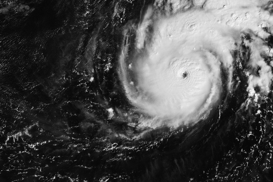
Himawari-8 image
MANILA (UPDATED) — Typhoon Rolly on Friday night continued to intensify into near the super typhoon category as it barreled closer to eastern Luzon, state weather bureau PAGASA said.
In its 11 p.m. bulletin, PAGASA said the tropical cyclone will pack 185-215 kilometers per hour maximum sustained winds by time it passes near the Bicol Region and makes landfall over the Aurora-Quezon area by Sunday night.
The tropical cyclone will bring its inner rainbands-eyewall region near or over Catanduanes and the Camarines Provinces on Sunday morning before its landfall, the weather bureau said.
The country’s 18th storm is expected to reach the super typhoon category within the next 12 hours, PAGASA added.
ADVERTISEMENT
The Japan Meteorological Agency has categorized Rolly as a "violent typhoon," the highest category.
Rolly was last estimated 895 kilometers east of Casiguran in Aurora at 10 p.m., packing maximum sustained winds of 215 kph with gusts of up to 265 kph.
Rolly’s trough will bring light to moderate with at times heavy rains over Visayas, Palawan including Cuyo Islands, Zamboanga Peninsula, Northern Mindanao, Caraga, and Sulu Archipelago Friday night until Saturday morning, according to PAGASA.
Areas in Bicol Region, Calabarzon, Metro Manila, Marinduque, and the northern portions of Occidental and Oriental Mindoro will experience heavy to intense rains due to the typhoon.
Flooding and flash floods, rain-induced landslides, and lahar flows may occur during intense or prolonged rainfall most especially in areas that are highly or very highly susceptible to these hazards, said PAGASA.
ADVERTISEMENT
After the typhoon whips Central Luzon, its center is forecast to exit Luzon around Monday morning.
The tropical cyclone is forecast to weaken but will remain in the typhoon category until it emerges over the West Philippine Sea, PAGASA said.
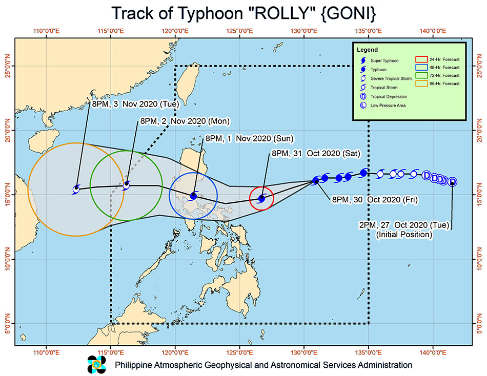
PAGASA forecast track of Typhoon Rolly
Tropical Cyclone Wind Signal (TCWS) No. 1 was hoisted over some areas in Luzon and Visayas, where 30-60 kph winds may rip roofs off nipa and cogon huts, damage rice crops and down banana plants:
Luzon:
Catanduanes
Camarines Norte
Camarines Sur
Albay
Sorsogon
Masbate including Ticao and Burias Islands
Quezon including Polillo Islands
Rizal
Laguna
Marinduque
Romblon
Visayas
Northern Samar
the northern portion of Samar (Tagapul-An, Almagro, Santo Nino, Tarangnan, Catbalogan City, Calbayog City, Santa Margarita, Gandara, Pagsanghan, San Jorge, Jiabong, Motiong, Paranas, San Jose de Buan, Matuguinao)
the northern portion of Eastern Samar (Taft, Can-Avid, Dolores, Maslog, Jipapad, Arteche, Oras, San Policarpo)
northern portion of Biliran (Kawayan, Maripipi)
PAGASA said tropical storm Atsani, a weather disturbance outside the Philippine area of responsibility (PAR), weakened into a tropical depression at 10 p.m., Friday.
Its center was estimated at 1,790 kilometers east of Visayas, packing maximum sustained winds of 55 km/h and gusts of up to 70 kph.
ADVERTISEMENT
The weather disturbance is forecast to enter PAR on Sunday, but is less likely to bring severe weather over the country over the next 3 days.
ABS-CBN is the leading media and entertainment company in the Philippines, offering quality content across TV, radio, digital, and film. Committed to public service and promoting Filipino values, ABS-CBN continues to inspire and connect audiences worldwide.
Our website is made possible by displaying online
advertisements to our visitors. Please consider supporting
us by disabling your ad blocker on our website.
Our website is made possible by displaying online
advertisements to our visitors. Please consider supporting
us by disabling your ad blocker on our website.