New LPA spotted off Mindanao as tropical depression nears PAR | ABS-CBN


ADVERTISEMENT

Welcome, Kapamilya! We use cookies to improve your browsing experience. Continuing to use this site means you agree to our use of cookies. Tell me more!
New LPA spotted off Mindanao as tropical depression nears PAR
New LPA spotted off Mindanao as tropical depression nears PAR
ABS-CBN News
Published Oct 29, 2020 06:56 AM PHT
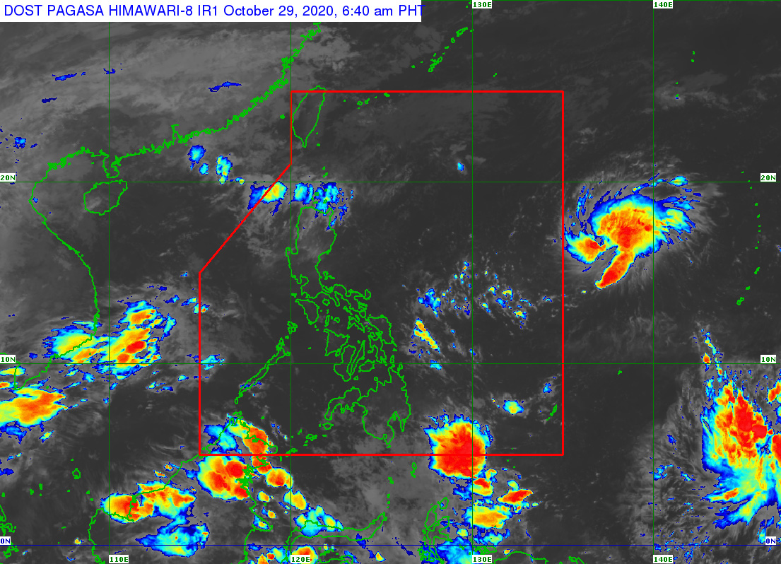
MANILA - A brewing storm was spotted east of Mindanao as the tropical depression off Central Luzon approached the Philippine area of responsibility, the state weather bureau said early Thursday.
MANILA - A brewing storm was spotted east of Mindanao as the tropical depression off Central Luzon approached the Philippine area of responsibility, the state weather bureau said early Thursday.
The tropical depression with international name Goni will be called "Rolly" when it enters PAR, said PAGASA weather forecaster Ezra Bulquerin.
The tropical depression with international name Goni will be called "Rolly" when it enters PAR, said PAGASA weather forecaster Ezra Bulquerin.
It was last spotted 1,705 km east of Central Luzon as of 3 a.m., moving west at 10 km per hour with maximum winds of 65 kph near the center and gusts of up to 80 kph.
It was last spotted 1,705 km east of Central Luzon as of 3 a.m., moving west at 10 km per hour with maximum winds of 65 kph near the center and gusts of up to 80 kph.
The low pressure area, meantime, was last spotted east of Mindanao, Bulquerin said.
The low pressure area, meantime, was last spotted east of Mindanao, Bulquerin said.
ADVERTISEMENT
"Posibleng pumasok ito ng PAR at magdala ng epekto kaya umantabay po tayo sa updates na ilalabas ng PAGASA," he said in PAGASA's daily briefing.
"Posibleng pumasok ito ng PAR at magdala ng epekto kaya umantabay po tayo sa updates na ilalabas ng PAGASA," he said in PAGASA's daily briefing.
(It's possible it may enter PAR and affect the country so let's watch out for updates from PAGASA.)
(It's possible it may enter PAR and affect the country so let's watch out for updates from PAGASA.)
Meantime, the intertropical convergence zone will bring scattered rains over Caraga ang Davao region while the northeasterly surface windflow will dampen Ilocos Norte, Apayao, Batanes, Cagayan, and Babuyan Islands.
Meantime, the intertropical convergence zone will bring scattered rains over Caraga ang Davao region while the northeasterly surface windflow will dampen Ilocos Norte, Apayao, Batanes, Cagayan, and Babuyan Islands.
Metro Manila and the rest of the country will generally experience fair weather with isolated rains due to localized thunderstorms.
Metro Manila and the rest of the country will generally experience fair weather with isolated rains due to localized thunderstorms.
ADVERTISEMENT
ADVERTISEMENT