Welcome, Kapamilya! We use cookies to improve your browsing experience. Continuing to use this site means you agree to our use of cookies. Tell me more!
Storm surge warning up in parts of Luzon, Visayas due to Paeng: PAGASA
Storm surge warning up in parts of Luzon, Visayas due to Paeng: PAGASA
ABS-CBN News
Published Oct 28, 2022 03:38 PM PHT
|
Updated Oct 28, 2022 03:57 PM PHT
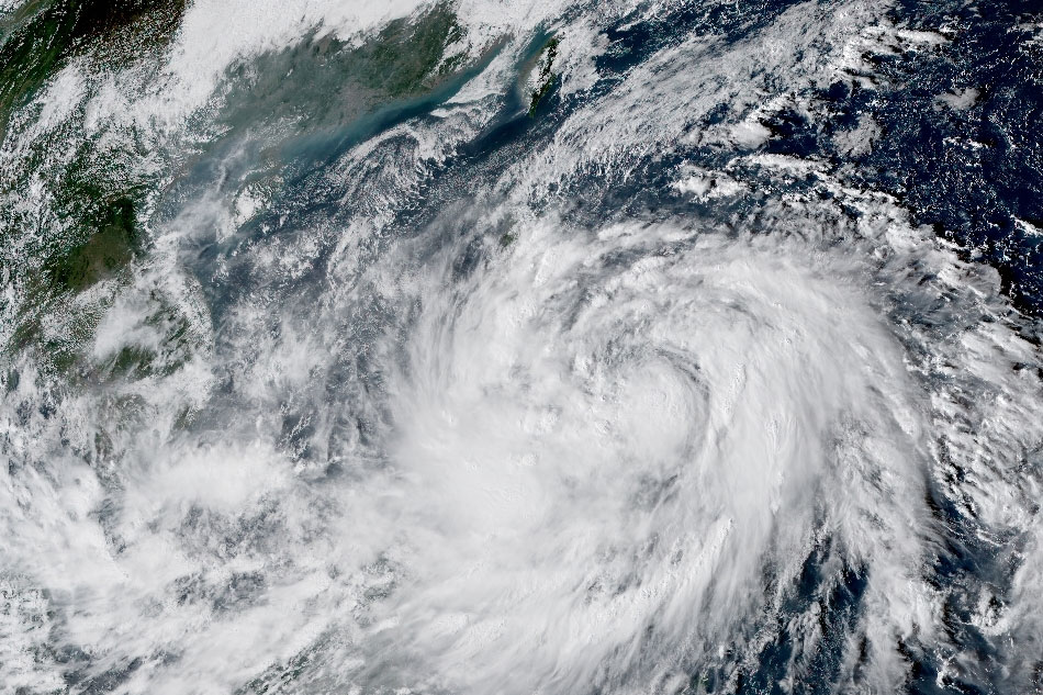
RAMMB/US NOAA/Himawari 8
MANILA — Tropical storm Paeng could unleash storm surges as high as 2 meters in some coastal areas in Luzon and Visayas, the state weather bureau warned Friday.
"Minimal to moderate risk" of storm surge up to 2 meters high may cause flooding in the low-lying and exposed coastal areas of Bicol Region, Quezon including Pollilo Islands, the eastern portion of Aurora, the northern and eastern portions of Northern Samar, and the eastern portion of Eastern Samar, PAGASA said in its 2 p.m. bulletin.
The term "storm surge" or "daluyong" refers to rising seas whipped up by a storm, creating a wall of water several meters higher than the normal tide level.
The large swells move faster than the cyclone and are sometimes spotted up to 1,000 kilometers ahead of a major storm. The surge can extend for dozens of kilometers inland, overwhelming homes and making roads impassable.
ADVERTISEMENT
"Storm surge becomes more dangerous when it arrives on top of a high tide. When this happens, it may flood areas that otherwise might have been dry or safe. On top of the storm surge, big and strong waves generated by powerful winds also comes with it," PAGASA said in its website.
A storm surge that is 1 to 2 meters high could cause moderate to significant damage to communities, disrupt all marine-related activities, and cause flooding in low lying areas, it added.
Different factors shape a storm surge, including storm intensity, forward speed, the size of a storm and the angle of approach to the coast. The underlying features of the land at the coast, including bays and estuaries, are also at play.
Paeng was 155 kilometers east northeast of Borongan City, Eastern Samar at 1 p.m., packing maximum sustained winds of 75 kilometers per hour near the center and up to 90 kph gusts, PAGASA said.
Paeng could strengthen into a severe tropical storm, make landfall twice, and bring heavy rains in the long weekend ahead of All Saints' and All Souls' Day, the weather agency earlier said.
From Friday until Saturday, PAGASA said heavy to intense with at times torrential rains are likely over Bicol Region and Eastern Visayas.
Moderate to heavy with at times intense rains will hit Quezon, Mimaropa, Caraga, Zamboanga Peninsula, the Bangsamoro, Northern Mindanao, and the rest of Visayas. Light to moderate with at times heavy rains are possible over Metro Manila, Cagayan Valley, Aurora, and the rest of Calabarzon and Mindanao.
In its 2 p.m. advisory, PAGASA raised Tropical Cyclone Wind Signal no. 2 in the following areas, where 62 to 88 kph winds are expected in at least 24 hours.
Luzon Catanduanes Albay Sorsogon Masbate including Ticao and Burias Islands Camarines Sur Camarines Norte Marinduque Northern portion of Romblon (Calatrava, San Andres, San Agustin, Romblon, Corcuera, Banton, Concepcion, Cajidiocan, San Fernando, Magdiwang) Quezon including Pollilo Islands Eastern portion of Batangas (Lobo, Taysan, Rosario, Padre Garcia, San Juan, Lipa City, Santo Tomas) Southeastern portion of Laguna (Alaminos, San Pablo City, Rizal, Nagcarlan, Majayjay, Luisiana, Cavinti, Paete, Kalayaan, Santa Maria, Mabitac, Pakil, Famy, Siniloan, Pangil, Lumban, Liliw)
Visayas Northern Samar Eastern Samar Samar Biliran Northern portion of Leyte (San Isidro, Calubian, Tabango, Leyte, Capoocan, Carigara, Barugo, San Miguel, Babatngon, Tacloban City, Alangalang, Santa Fe, Palo, Tanauan, Dagami, Pastrana, Jaro, Kananga, Villaba, Tunga, Tabontabon, Tolosa)
The following areas are under wind signal no. 1, said PAGASA.
Luzon Rest of Romblon Rest of Laguna Rizal Occidental Mindoro including Lubang Islands Oriental Mindoro Calamian Islands Cuyo Islands Rest of Batangas Cavite Metro Manila Bataan Pampanga Bulacan Tarlac Nueva Ecija Aurora Zambales Pangasinan La Union Benguet Nueva Vizcaya Quirino Central and southern portions of Isabela (San Agustin, Jones, City of Santiago, Cordon, Echague, Dinapigue, San Mariano, San Guillermo, Angadanan, City of Cauayan, Benito Soliven, Ramon, San Isidro, Alicia, San Mateo, Cabatuan, Luna, Reina Mercedes, Naguilian, Palanan, Aurora, Burgos, San Manuel, Gamu, Ilagan City, Divilacan) Ifugao Southern portion of Ilocos Sur (Sugpon, Cervantes, Alilem, Suyo, Tagudin, Santa Cruz, Sigay), and the southwestern portion of Mountain Province (Bauko, Sabangan, Tadian)
ADVERTISEMENT
Visayas Southern Leyte Cebu including Bantayan and Camotes Islands Bohol Negros Occidental Negros Oriental Guimaras Aklan Antique Capiz Iloilo Siquijor Rest of Leyte
Mindanao Dinagat Islands Surigao del Norte including Siargao and Bucas Grande Islands Northern portion of Surigao del Sur (Carrascal, Cantilan, Madrid, Carmen, Lanuza, Cortes, City of Tandag, Bayabas, Cagwait, San Miguel, Tago, Marihatag) Agusan del Norte Northeastern portion of Agusan del Sur (Sibagat) Camiguin Eastern portion of Misamis Oriental (Gingoog City, Magsaysay, Medina, Talisayan, Balingoan, Kinoguitan)
ABS-CBN is the leading media and entertainment company in the Philippines, offering quality content across TV, radio, digital, and film. Committed to public service and promoting Filipino values, ABS-CBN continues to inspire and connect audiences worldwide.
Our website is made possible by displaying online
advertisements to our visitors. Please consider supporting
us by disabling your ad blocker on our website.
Our website is made possible by displaying online
advertisements to our visitors. Please consider supporting
us by disabling your ad blocker on our website.