Paeng may make landfall twice; signal no. 3 possible in some areas: PAGASA
Rowegie Abanto,
ABS-CBN News
Published Oct 28, 2022 01:21 PM PHT
|
Updated Oct 28, 2022 07:29 PM PHT
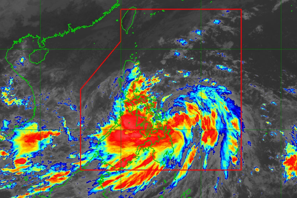
This image shows the location of tropical storm Paeng before Friday noon. PAHASA
MANILA — Metro Manila and large swaths of the country will experience heavy rains and strong winds this weekend due to tropical storm Paeng, which could make landfall twice and prompt wind signal no. 3 in some areas, PAGASA said on Friday.
Paeng is expected to slam into Catanduanes on Saturday morning before heading to the northern portion of Camarines Sur and eastern Camarines Norte, the state weather bureau said in its 11 a.m. bulletin.
On Sunday morning, Paeng could make a second landfall over the east coast of Quezon including Polillo Islands or Aurora, said PAGASA.
PAGASA photo
Based on the latest track and intensity forecast, PAGASA said it might raise Tropical Cyclone Wind Signal No. 3.
ADVERTISEMENT
Under this signal, 89 to 117 kph winds could cause minor roof damage on well-constructed houses, knock down power, disrupt telecommunications and water supply, and break small tress, PAGASA said.
At 10 a.m., Paeng was 220 kilometers east-northeast of Borongan City, Eastern Samar, keeping its strength with maximum sustained winds of 75 kilometers per hour near the center and up to 90 kph gusts.
Paeng accelerated, moving west northwestward at 25 kph, PAGASA said.
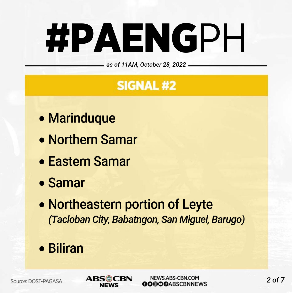
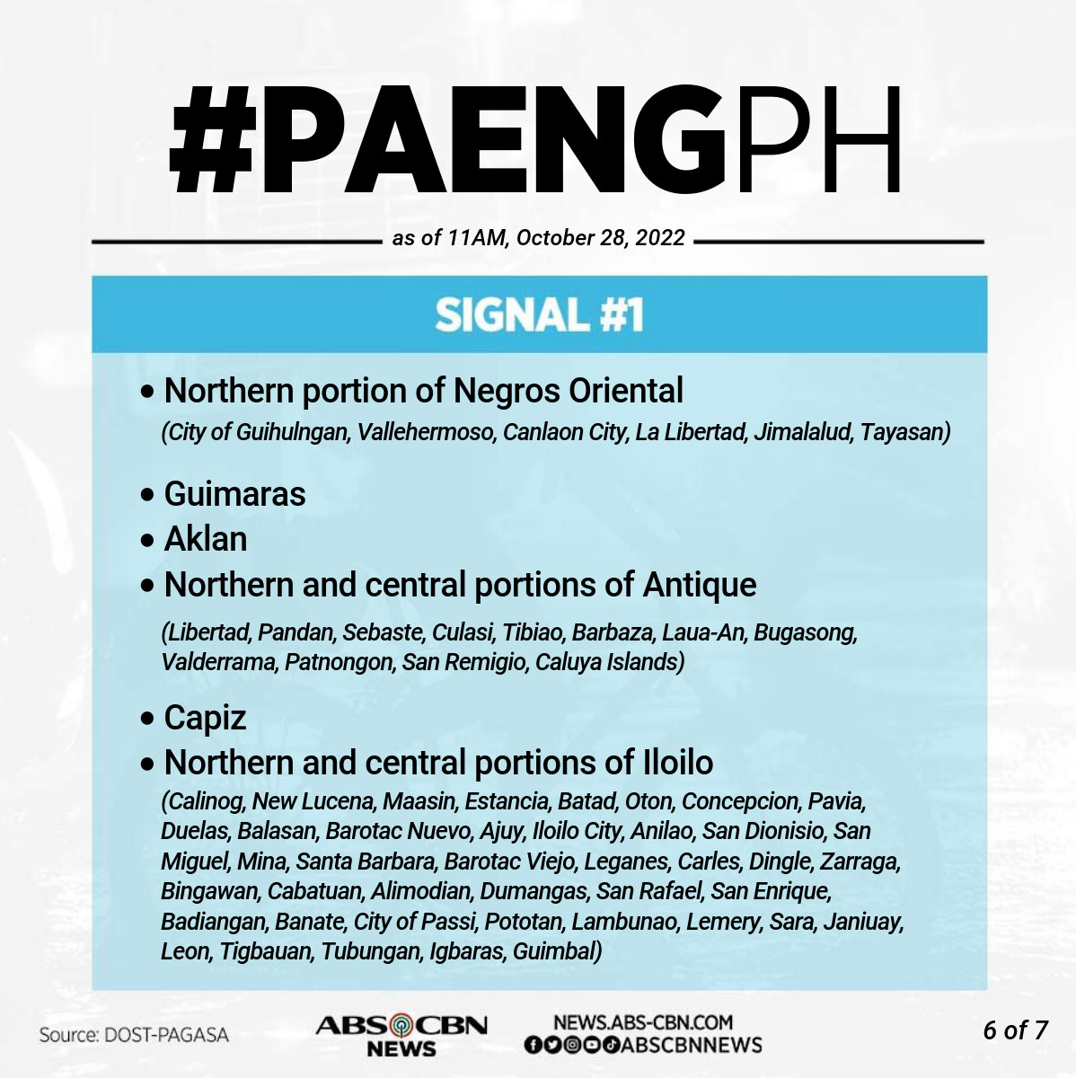
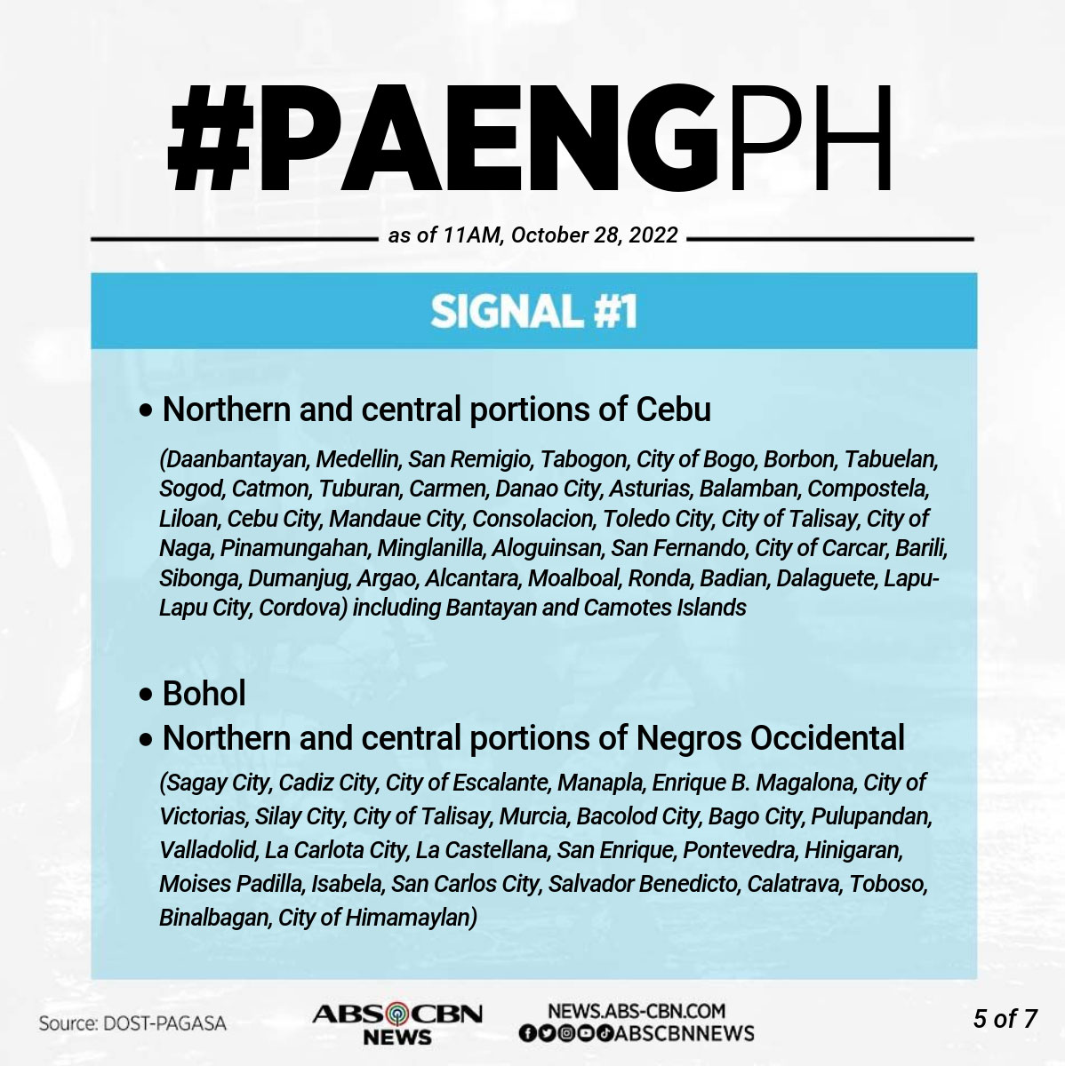
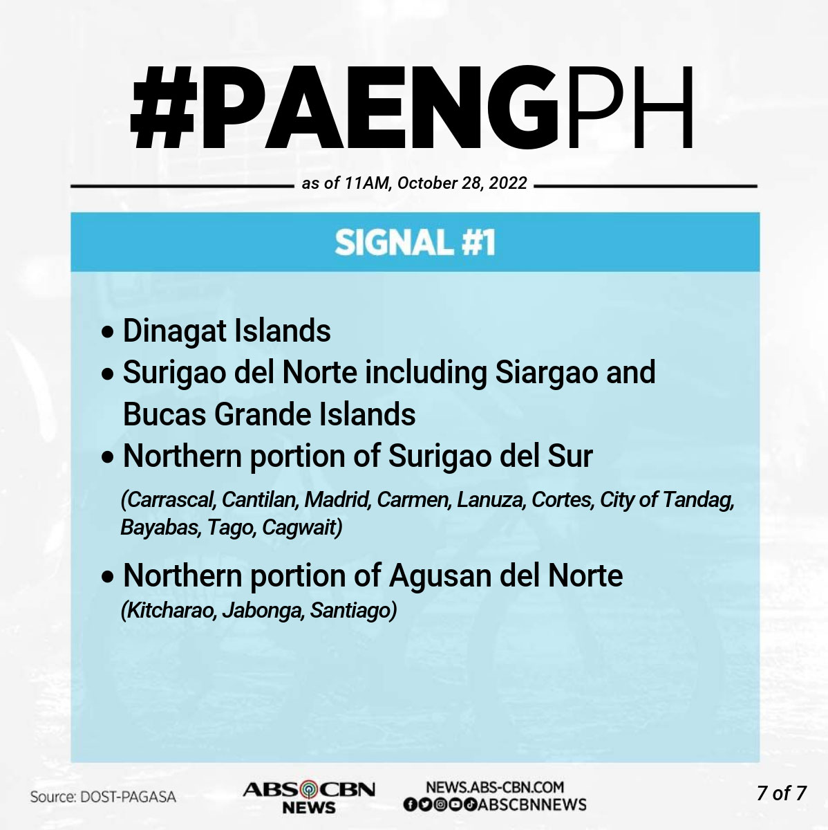
The weather agency raised Signal no. 2 in the following areas, where 62 to 88 kph winds are expected in at least 24 hours.
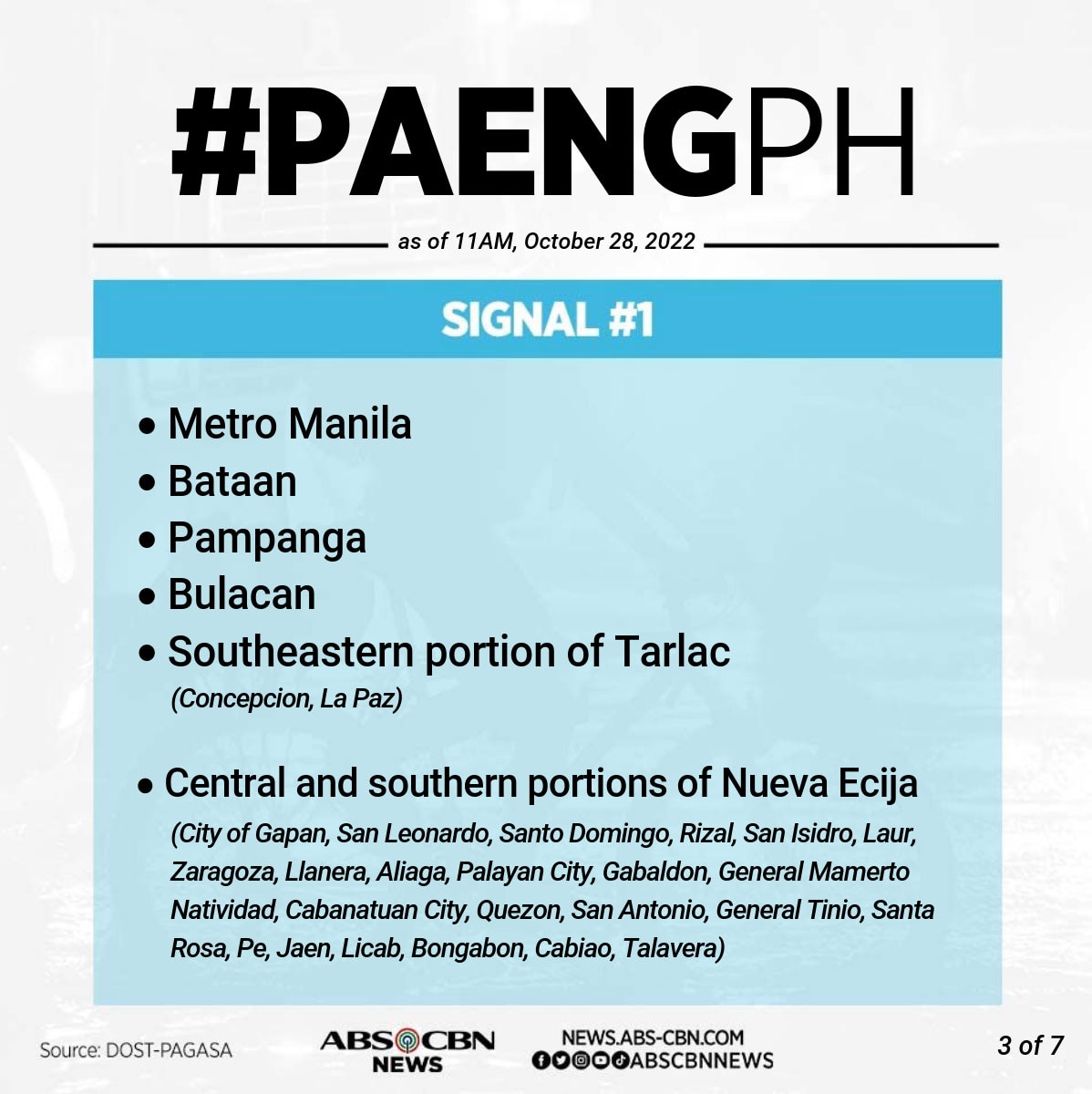
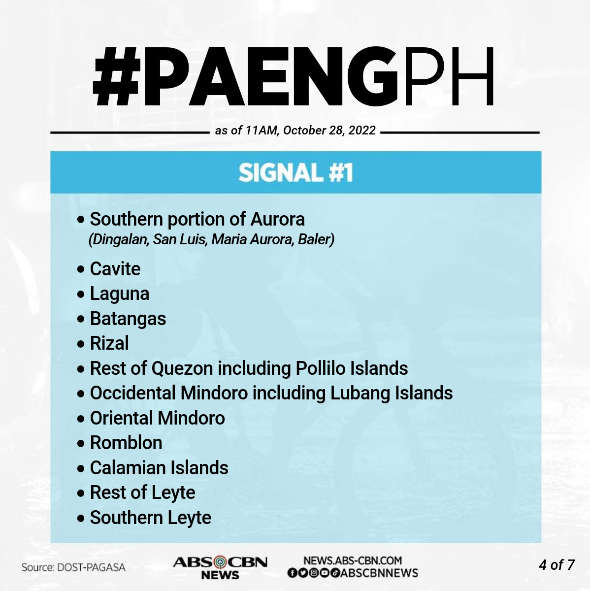
Signal no. 1 was raised in Metro Manila and the following areas, where 39 to 61 kph winds are expected in 36 hours, PAGASA said.
ADVERTISEMENT
HEAVY RAINS
Paeng is predicted to intensify while moving over the Philippine Sea and may become a severe tropical storm within 24 hours, said PAGASA.
But due to its possible second landfall in Bicol region, Paeng "is less likely"' to reach typhoon category, the weather bureau said.
Paeng will bring heavy rains in parts of the country, including Metro Manila, home to around 13 million people.
"Kahit dito sa Metro Manila, inaabisuhan na po natin ang ating mga kababayan na kung maaari ay manatili na lang muna sa ating mga tahanan dahil mas ligtas po doon," PAGASA weather forecaster Veronica Torres told ABS-CBN's TeleRadyo.
(Even here in Metro Manila, we're advising residents to stay home because it's safer there.)
From Friday through early Saturday morning, PAGASA warned that heavy to intense with at times torrential rains are likely over Bicol region and Eastern Visayas.
Moderate to heavy with at times intense rains are possible in Quezon, Mimaropa, Caraga, Zamboanga Peninsula, the Bangsamoro, Northern Mindanao, and the rest of Visayas, while light to moderate with at times heavy rains may lash Metro Manila, Cagayan Valley, Aurora, and the rest of Calabarzon and Mindanao.
By Saturday morning through Sunday, PAGASA said heavy to intense with at times torrential rains may hammer Calabarzon, Bicol region, Aurora, Isabela, Nueva Vizcaya, and Quirino.
Moderate to heavy with at times intense rains will hit Metro Manila, mainland Cagayan, the Cordilleras, Western Visayas, Marinduque, Romblon, Mindoro Provinces, and the rest of Central Luzon. Light to moderate with at times heavy rains are possible over Zamboanga Peninsula and the rest of Luzon and Visayas.
"Under these conditions, flooding and rain-induced landslides are expected," PAGASA said.
ABS-CBN is the leading media and entertainment company in the Philippines, offering quality content across TV, radio, digital, and film. Committed to public service and promoting Filipino values, ABS-CBN continues to inspire and connect audiences worldwide.
Our website is made possible by displaying online
advertisements to our visitors. Please consider supporting
us by disabling your ad blocker on our website.
Our website is made possible by displaying online
advertisements to our visitors. Please consider supporting
us by disabling your ad blocker on our website.