Typhoon Quinta slightly intensifies as it traverses West PH Sea | ABS-CBN


Welcome, Kapamilya! We use cookies to improve your browsing experience. Continuing to use this site means you agree to our use of cookies. Tell me more!
Typhoon Quinta slightly intensifies as it traverses West PH Sea
Typhoon Quinta slightly intensifies as it traverses West PH Sea
Rose Carmelle Lacuata,
ABS-CBN News
Published Oct 26, 2020 06:13 PM PHT
|
Updated Oct 27, 2020 12:20 AM PHT

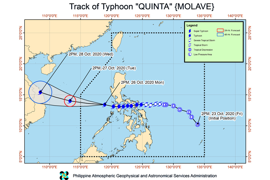
MANILA - Typhoon Quinta slightly intensified as it moved over the West Philippine Sea after lashing southern Luzon, the state weather bureau said Monday afternoon.
MANILA - Typhoon Quinta slightly intensified as it moved over the West Philippine Sea after lashing southern Luzon, the state weather bureau said Monday afternoon.
The typhoon's strong winds and heavy rains shut down power lines and inundated parts of Luzon, prompting the suspension of classes and forcing tens of thousands to flee their homes.
The typhoon's strong winds and heavy rains shut down power lines and inundated parts of Luzon, prompting the suspension of classes and forcing tens of thousands to flee their homes.
Quinta was last estimated 310 kilometers west of Calapan City, Oriental Mindoro as of 4 p.m., moving west at 25 kph while packing maximum winds of 130 kph and gusts of up to 160 kph, PAGASA said in its 5:00 pm weather bulletin.
Quinta was last estimated 310 kilometers west of Calapan City, Oriental Mindoro as of 4 p.m., moving west at 25 kph while packing maximum winds of 130 kph and gusts of up to 160 kph, PAGASA said in its 5:00 pm weather bulletin.
Quinta may reach its peak intensity within 24 hours and leave the Philippine area of responsibility on Tuesday morning, the state weather bureau said.
Quinta may reach its peak intensity within 24 hours and leave the Philippine area of responsibility on Tuesday morning, the state weather bureau said.
ADVERTISEMENT
Tropical cyclone warning signal no. 1 was hoisted over the following areas, where 30-60 kph winds may rip roofs off nipa and cogon huts, damage rice crops and down banana plants:
Tropical cyclone warning signal no. 1 was hoisted over the following areas, where 30-60 kph winds may rip roofs off nipa and cogon huts, damage rice crops and down banana plants:
- Batangas
- Occidental Mindoro including Lubang Island
- Oriental Mindoro
- Calamian Islands
- the extreme northern portion of Antique (Caluya)
- Batangas
- Occidental Mindoro including Lubang Island
- Oriental Mindoro
- Calamian Islands
- the extreme northern portion of Antique (Caluya)
All other tropical cyclone wind signals have been lifted.
All other tropical cyclone wind signals have been lifted.
Meanwhile, a low pressure area spotted 1,945 km east of Southern Luzon may enter the Philippine area of responsibility on Wednesday or Thursday morning but is less likely to develop into tropical depression in the next 48 hours, PAGASA added.
Meanwhile, a low pressure area spotted 1,945 km east of Southern Luzon may enter the Philippine area of responsibility on Wednesday or Thursday morning but is less likely to develop into tropical depression in the next 48 hours, PAGASA added.
From Monday to Tuesday morning, Quinta will bring moderate to heavy with at times intense rains over Occidental Mindoro, Oriental Mindoro, northern Palawan including Calamian, and Cuyo Islands, Calabarzon, Aurora, and Isabela.
From Monday to Tuesday morning, Quinta will bring moderate to heavy with at times intense rains over Occidental Mindoro, Oriental Mindoro, northern Palawan including Calamian, and Cuyo Islands, Calabarzon, Aurora, and Isabela.
The tail-end of a frontal system will bring moderate to heavy rains over Cagayan, Apayao, Kalinga, Abra, Ilocos Norte, and Ilocos Sur.
The tail-end of a frontal system will bring moderate to heavy rains over Cagayan, Apayao, Kalinga, Abra, Ilocos Norte, and Ilocos Sur.
ADVERTISEMENT
The two weather systems will also bring light to moderate with at times heavy rains over Metro Manila, Western Visayas, Zamboanga Peninsula, Bangsamoro and the rest of Luzon.
The two weather systems will also bring light to moderate with at times heavy rains over Metro Manila, Western Visayas, Zamboanga Peninsula, Bangsamoro and the rest of Luzon.
Flooding and rain-induced landslides may occur during heavy or prolonged rainfall especially in areas that are highly susceptible to these hazards, PAGASA warned.
Flooding and rain-induced landslides may occur during heavy or prolonged rainfall especially in areas that are highly susceptible to these hazards, PAGASA warned.
Visit the ABS-CBN Weather Center for updates.
Visit the ABS-CBN Weather Center for updates.
ADVERTISEMENT
ADVERTISEMENT