Quinta, now a typhoon, makes landfall over Albay | ABS-CBN


Welcome, Kapamilya! We use cookies to improve your browsing experience. Continuing to use this site means you agree to our use of cookies. Tell me more!
Quinta, now a typhoon, makes landfall over Albay
Quinta, now a typhoon, makes landfall over Albay
ABS-CBN News
Published Oct 25, 2020 06:05 PM PHT
|
Updated Oct 26, 2020 07:20 AM PHT

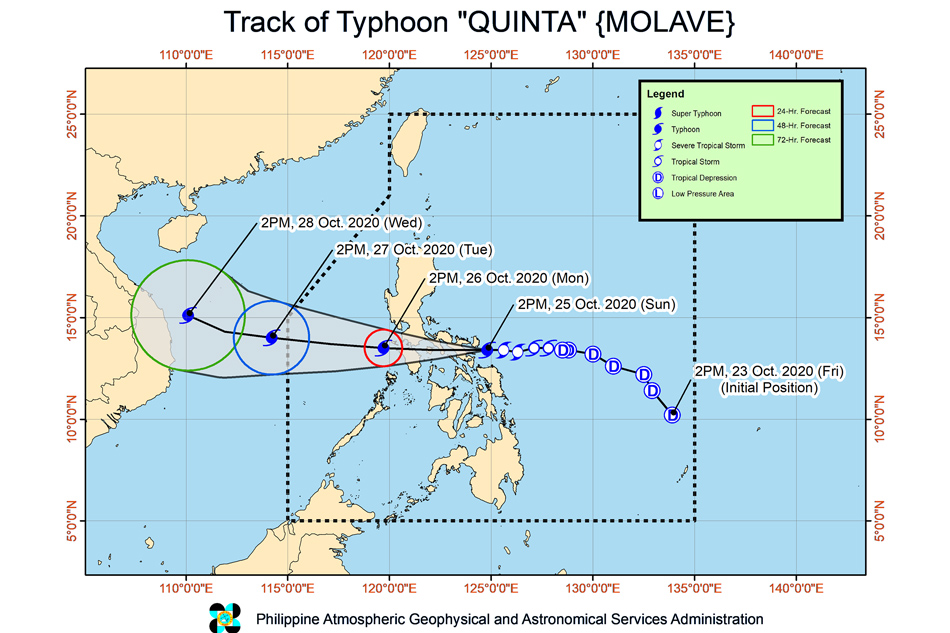
MANILA (UPDATE) - Typhoon "Quinta" made landfall over Albay after it further intensified into a typhoon Sunday, the state weather bureau said.
MANILA (UPDATE) - Typhoon "Quinta" made landfall over Albay after it further intensified into a typhoon Sunday, the state weather bureau said.
PAGASA said Quinta made landfall over San Miguel Island in Tabaco City, Albay at 6:10 p.m.
PAGASA said Quinta made landfall over San Miguel Island in Tabaco City, Albay at 6:10 p.m.
It made its second landfall at 6:50 p.m. in the vicinity of Malinao, Albay.
It made its second landfall at 6:50 p.m. in the vicinity of Malinao, Albay.
Quinta intensified into a typhoon at 2 p.m. Sunday. It is expected to further intensify while traversing the West Philippine Sea.
Quinta intensified into a typhoon at 2 p.m. Sunday. It is expected to further intensify while traversing the West Philippine Sea.
ADVERTISEMENT
The country's 17th storm this year was last estimated in the vicinity of Malinao, Albay as of 7 p.m., moving west at 25 km per hour while packing winds of 130 kph and gusts of up to 180 kph, PAGASA said.
The country's 17th storm this year was last estimated in the vicinity of Malinao, Albay as of 7 p.m., moving west at 25 km per hour while packing winds of 130 kph and gusts of up to 180 kph, PAGASA said.
It is forecast to move generally westward as it traverses Southern Luzon until Monday afternoon, and is likely to exit the Philippine area of responsibility (PAR) on Tuesday, PAGASA added.
It is forecast to move generally westward as it traverses Southern Luzon until Monday afternoon, and is likely to exit the Philippine area of responsibility (PAR) on Tuesday, PAGASA added.
On Sunday to Monday morning, the storm will bring moderate to heavy with at times intense rains over the Bicol region, Calabarzon, Aurora, Occidental Mindoro, Oriental Mindoro, Romblon, Marinduque, Calamian Islands, Northern Samar, Eastern Samar, Samar, Biliran, Aklan, Capiz, and Antique.
On Sunday to Monday morning, the storm will bring moderate to heavy with at times intense rains over the Bicol region, Calabarzon, Aurora, Occidental Mindoro, Oriental Mindoro, Romblon, Marinduque, Calamian Islands, Northern Samar, Eastern Samar, Samar, Biliran, Aklan, Capiz, and Antique.
The northern portions of mainland Cagayan, Isabela, Apayao, and Ilocos Norte, meantime, will experience moderate to heavy with at times intense rains due to the tail-end of a frontal system, PAGASA said.
The northern portions of mainland Cagayan, Isabela, Apayao, and Ilocos Norte, meantime, will experience moderate to heavy with at times intense rains due to the tail-end of a frontal system, PAGASA said.
The two weather systems will bring light to moderate with at times heavy rains over Metro Manila, the rest of Luzon, Zamboanga Peninsula, Bangsamoro, Northern Mindanao, Caraga, and the rest of Visayas.
The two weather systems will bring light to moderate with at times heavy rains over Metro Manila, the rest of Luzon, Zamboanga Peninsula, Bangsamoro, Northern Mindanao, Caraga, and the rest of Visayas.
PAGASA also warned of possible flooding, including flashfloods, and rain-induced landslides in areas susceptible to these hazards.
PAGASA also warned of possible flooding, including flashfloods, and rain-induced landslides in areas susceptible to these hazards.
Two to three meter waves may also affect the eastern coastal areas of Quezon, Camarines Norte, and Camarines Sur, and 1-2 meters over the coastal areas of Northern Samar, Batangas, Marinduque, Romblon, Occidental Mindoro, Oriental Mindoro, and the rest of Quezon and Bicol Region.
Two to three meter waves may also affect the eastern coastal areas of Quezon, Camarines Norte, and Camarines Sur, and 1-2 meters over the coastal areas of Northern Samar, Batangas, Marinduque, Romblon, Occidental Mindoro, Oriental Mindoro, and the rest of Quezon and Bicol Region.
Tropical cyclone warning signal no. 3 was hoisted over the following areas, where 121-170 kph winds were expected within 18 hours and may uproot trees and cause moderate to heavy damage:
Tropical cyclone warning signal no. 3 was hoisted over the following areas, where 121-170 kph winds were expected within 18 hours and may uproot trees and cause moderate to heavy damage:
- Catanduanes
- Camarines Norte
- Camarines Sur
- Albay
- Sorsogon
- Burias and Ticao Islands
- the southern portion of Quezon (Mauban, Sampaloc, Lucban, Candelaria, Dolores, Tiaong, San Antonio, Sariaya, Tayabas City, Lucena City City, Pagbilao, Atimonan, Padre Burgos, Agdangan, Unisan, Plaridel, Gumaca, Pitogo, Macalelon, General Luna, Catanauan, Mulanay, San Francisco, San Andres, San Narciso, Buenavista, Lopez, Guinayangan, Calauag, Tagkawayan, Quezon, Alabat, Perez)
- the southeastern portion of Laguna (Paete, Kalayaan, Lumban, Cavinti, Luisiana, Majayjay, Liliw, Rizal, Nagcarlan, San Pablo City, Alaminos, Magdalena, Pagsanjan)
- Batangas
- the extreme northern portion of Romblon (Corcuera, Banton, Concepcion)
- Marinduque
- the northern portion of Oriental Mindoro (Bongabong, Bansud, Gloria, Pinamalayan, Socorro, Pola, Naujan, Naujan Lake, Victoria, Calapan City, Baco, San Teodoro, Puerto Galera)
- the northern portion of Occidental Mindoro (Abra de Ilog, Paluan, Mamburao, Santa Cruz, Sablayan) including Lubang Island
Tropical cyclone warning signal no. 2, on the other hand, was hoisted over the following areas, where 61-120 kph winds were expected within 24 hours and may damage wooden and old electric posts:
Tropical cyclone warning signal no. 2, on the other hand, was hoisted over the following areas, where 61-120 kph winds were expected within 24 hours and may damage wooden and old electric posts:
- Masbate
- the central portion of Quezon (Infanta, Real) including Polillo Islands
- Cavite
- the rest of Laguna
- the rest of Romblon
- the rest of Oriental Mindoro
- the rest of Occidental Mindoro
- Masbate
- the central portion of Quezon (Infanta, Real) including Polillo Islands
- Cavite
- the rest of Laguna
- the rest of Romblon
- the rest of Oriental Mindoro
- the rest of Occidental Mindoro
Tropical cyclone warning signal no. 1 was raised over the following areas, where 30-60 kph winds may rip roofs off nipa and cogon huts, damage rice crops and down banana plants:
Tropical cyclone warning signal no. 1 was raised over the following areas, where 30-60 kph winds may rip roofs off nipa and cogon huts, damage rice crops and down banana plants:
- the rest of Quezon
- Rizal
- Metro Manila
- Bulacan
- Pampanga
- Bataan
- the southern portion of Zambales (San Marcelino, San Felipe, San Narciso, Castillejos, Subic, San Antonio, Olongapo City, Botolan, Cabangan)
- Calamian Islands
- The northern portion of Samar (Calbayog City, Matuguinao, Tagapul-An, Santo Nino, Almagro, Santa Margarita, Gandara, San Jose de Buan, Pagsanghan, Tarangnan, San Jorge, Catbalogan City, Jiabong, Motiong, Paranas)
- the northern portion of Eastern Samar (Maslog, Jipapad, Arteche, San Policarpo, Oras, Dolores, Can-Avid, Taft)
- the northern portion of Capiz (Sapi-An, Ivisan, Roxas City, Panay, Pilar, Pontevedra, President Roxas)
- Aklan
- the northern portion of Antique (Caluya, Libertad, Pandan, Sebaste, Culasi)
- the northeastern portion of Iloilo (Batad, Balasan, Estancia, Carles)
Visit the ABS-CBN Weather Center for updates.
Visit the ABS-CBN Weather Center for updates.
Read More:
weather
weather top
PAGASA
LPA
QuintaPH
severe tropical storm Quinta
severe tropical storm
Philippine weather
regions
regional news
ADVERTISEMENT
ADVERTISEMENT