More areas under tropical cyclone signals as Pepito hammers Luzon | ABS-CBN


ADVERTISEMENT

Welcome, Kapamilya! We use cookies to improve your browsing experience. Continuing to use this site means you agree to our use of cookies. Tell me more!
More areas under tropical cyclone signals as Pepito hammers Luzon
More areas under tropical cyclone signals as Pepito hammers Luzon
ABS-CBN News
Published Oct 21, 2020 04:04 AM PHT
|
Updated Oct 21, 2020 06:32 AM PHT
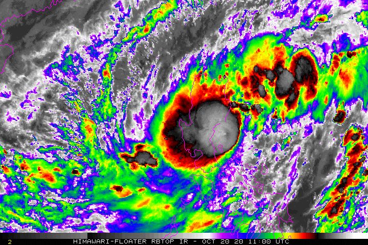
MANILA - More areas in the country were placed under tropical cyclone signals as tropical storm Pepito continued to move across Luzon and over the Caraballo-Cordillera Mountains early Wednesday, state weather bureau PAGASA said.
MANILA - More areas in the country were placed under tropical cyclone signals as tropical storm Pepito continued to move across Luzon and over the Caraballo-Cordillera Mountains early Wednesday, state weather bureau PAGASA said.
In its 2 a.m advisory, PAGASA said Pepito was spotted 1 a.m. in the vicinity of Bambang, Nueva Vizcaya packing maximum sustained winds of 75 kph near the center and 125 kph gusts while moving west-northwestward at 20 kph.
In its 2 a.m advisory, PAGASA said Pepito was spotted 1 a.m. in the vicinity of Bambang, Nueva Vizcaya packing maximum sustained winds of 75 kph near the center and 125 kph gusts while moving west-northwestward at 20 kph.
PAGASA said the tropical storm is forecast to move generally west-northwestward or westward over the Luzon landmass and emerge over the West Philippine Sea by Wednesday morning before leaving the Philippine area of responsibility (PAR) Thursday morning or afternoon.
PAGASA said the tropical storm is forecast to move generally west-northwestward or westward over the Luzon landmass and emerge over the West Philippine Sea by Wednesday morning before leaving the Philippine area of responsibility (PAR) Thursday morning or afternoon.
The state weather bureau said Pepito will likely maintain its strength while crossing Luzon but a slight weakening in its intensity remains a possibility.
The state weather bureau said Pepito will likely maintain its strength while crossing Luzon but a slight weakening in its intensity remains a possibility.
ADVERTISEMENT
The weather disturbance is expected to further intensify and will likely reach severe tropical storm category Thursday, said PAGASA.
The weather disturbance is expected to further intensify and will likely reach severe tropical storm category Thursday, said PAGASA.
Pepito will bring moderate to heavy rains over Central Luzon, Cordillera Administrative Region, northern Quezon (including Polillo Islands), Nueva Vizcaya, Quirino, Isabela, mainland Cagayan, La Union, and Pangasinan.
Pepito will bring moderate to heavy rains over Central Luzon, Cordillera Administrative Region, northern Quezon (including Polillo Islands), Nueva Vizcaya, Quirino, Isabela, mainland Cagayan, La Union, and Pangasinan.
Light to moderate with at times heavy rains meanwhile will prevail over Metro Manila and the rest of Luzon, Western Visayas, Zamboanga Peninsula, and Bangsamoro.
Light to moderate with at times heavy rains meanwhile will prevail over Metro Manila and the rest of Luzon, Western Visayas, Zamboanga Peninsula, and Bangsamoro.
PAGASA warned flooding (including flash floods) and rain-induced landslides may occur during heavy or prolonged rainfall in affected areas.
PAGASA warned flooding (including flash floods) and rain-induced landslides may occur during heavy or prolonged rainfall in affected areas.
More areas were also added to places under tropical cyclone wind signals (TCWS).
More areas were also added to places under tropical cyclone wind signals (TCWS).
TCWS No. 2 was raised over the following areas where 61-120 kph winds were expected within 24 hours and may damage wooden and old electric posts:
TCWS No. 2 was raised over the following areas where 61-120 kph winds were expected within 24 hours and may damage wooden and old electric posts:
- Ilocos Sur
- La Union
- Pangasinan
- Ifugao
- Mountain Province
- Benguet
- southern portion of Isabela (Palanan, San Mariano, Benito Soliven, Naguilian, Gamu, Burgos, San Manuel, Aurora, Cabatuan, Luna, Reina Mercedes, Cauayan City, Dinapigue, San Guillermo, Angadanan, Alicia, San Mateo, Ramon, San Isidro, Echague, San Agustin, Jones, Santiago City, Cordon)
- Quirino
- Nueva Vizcaya
- Aurora
- Nueva Ecija
- Tarlac
- northern portion of Zambales (Iba, Palauig, Masinloc, Candelaria, Santa Cruz, Botolan, Cabangan)
The agency raised TCWS No. 1 in the following areas where 30-60 kph winds may rip roofs off nipa and cogon huts, damage rice crops and down banana plants:
The agency raised TCWS No. 1 in the following areas where 30-60 kph winds may rip roofs off nipa and cogon huts, damage rice crops and down banana plants:
- Ilocos Norte
- Kalinga
- Abra
- the rest of Isabela
- the rest of Zambales
- Pampanga
- Bulacan
- Bataan
- Metro Manila
- Rizal
- northern portion of Quezon (General Nakar, Infanta, Real) including Polillo Islands.
- Ilocos Norte
- Kalinga
- Abra
- the rest of Isabela
- the rest of Zambales
- Pampanga
- Bulacan
- Bataan
- Metro Manila
- Rizal
- northern portion of Quezon (General Nakar, Infanta, Real) including Polillo Islands.
The weather bureau warned the seaboards of areas under TCWS will experience rough to very rough seas and that sea travel is risky over these areas, especially for those using small seacrafts.
The weather bureau warned the seaboards of areas under TCWS will experience rough to very rough seas and that sea travel is risky over these areas, especially for those using small seacrafts.
Gale warning meanwhile is in effect over the seaboards of Batanes and Cagayan and the western seaboards of Batangas, Occidental Mindoro (including Lubang Island), and Palawan (including Calamian Islands) due to rough to very rough seas, PAGASA said
Gale warning meanwhile is in effect over the seaboards of Batanes and Cagayan and the western seaboards of Batangas, Occidental Mindoro (including Lubang Island), and Palawan (including Calamian Islands) due to rough to very rough seas, PAGASA said
Moderate to rough seas will also prevail over Palawan and the eastern seaboards of Southern Luzon, Eastern Visayas, Caraga, and Davao Region, PAGASA said, advising those with small boats to take precautionary measures when venturing out to sea.
Moderate to rough seas will also prevail over Palawan and the eastern seaboards of Southern Luzon, Eastern Visayas, Caraga, and Davao Region, PAGASA said, advising those with small boats to take precautionary measures when venturing out to sea.
PAGASA meanwhile said a tropical depression was spotted outside PAR, and was approximately 1,825 km east-northeast of Basco, Batanes, while packing maximum sustained winds of 55 kph near the center and 70 kph gusts while moving east-southeastward at 15 kph.
PAGASA meanwhile said a tropical depression was spotted outside PAR, and was approximately 1,825 km east-northeast of Basco, Batanes, while packing maximum sustained winds of 55 kph near the center and 70 kph gusts while moving east-southeastward at 15 kph.
But the weather agency said it is less likely to enter PAR.
But the weather agency said it is less likely to enter PAR.
Visit the ABS-CBN Weather for updates.
Visit the ABS-CBN Weather for updates.
Read More:
weather
weather update
weather top
Pepito
Bagyo 2020
Typhoon 2020
PAGASA
Pepito October 2020
Philippines weather October 2020
Manila weather October 2020
ADVERTISEMENT
ADVERTISEMENT