Welcome, Kapamilya! We use cookies to improve your browsing experience. Continuing to use this site means you agree to our use of cookies. Tell me more!
Several Luzon areas under Signal No. 2 as storm Karding intensifies
Several Luzon areas under Signal No. 2 as storm Karding intensifies
ABS-CBN News
Published Sep 24, 2022 06:08 PM PHT
|
Updated Sep 24, 2022 09:22 PM PHT
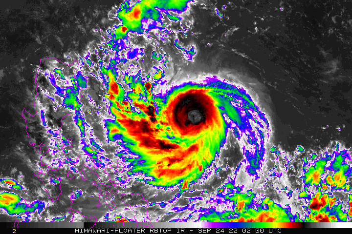
NOAA/HIMAWARI 8 image
Metro Manila, nearby areas under Signal No. 1
MANILA — Several areas in Luzon were placed under Tropical Cyclone Wind Signal No. 2 as Severe Tropical Storm Karding continues to intensify, PAGASA said Saturday.
In its latest bulletin issued 5 p.m., the state weather bureau advised residents of these areas to prepare for rains and strong winds over the weekend throughout Monday.
PAGASA raised Tropical Cyclone Wind Signals under the following areas due to the threat of Karding:
SIGNAL NO. 2
Southeastern portion of Isabela (Dinapigue, Jones, San Agustin, Echague, San Guillermo, San Mariano)
Southeastern portion of Quirino (Nagtipunan, Maddela)
Southeastern portion of Nueva Vizcaya (Alfonso Castaneda), the eastern portion of Nueva Ecija (Bongabon, Laur, Palayan City, General Tinio, Gabaldon, Pantabangan, Rizal)
Aurora
Eastern portion of Bulacan (Doña Remedios Trinidad, Norzagaray)
Eastern portion of Rizal (Rodriguez, City of Antipolo, Tanay)
Northern and central portion of Quezon (General Nakar, Pollilo Islands, Infanta, Real, Mauban, Perez, Alabat, Quezon, Calauag, Tagkawayan, Guinayangan)
Northwestern portion of Camarines Sur (Del Gallego, Ragay, Lupi, Sipocot)
Camarines Norte
SIGNAL NO. 1
Metro Manila
Southern portion of Cagayan (Peñablanca, Iguig, Tuguegarao City, Enrile, Solana, Tuao, Piat, Amulung, Rizal)
Rest of Isabela
Rest of Quirino
Rest of Nueva Vizcaya
Southern portion of Apayao (Conner)
Abra
Kalinga
Mountain Province
Ifugao
Benguet
Southern portion of Ilocos Norte (Nueva Era, Badoc, Pinili, Banna, City of Batac, Currimao, Paoay, Marcos)
Ilocos Sur
La Union
Pangasinan
Rest of Nueva Ecija
Rest of Bulacan
Tarlac
Pampanga
Zambales
Bataan
Rest of Laguna
Rest of Rizal
Rest of Quezon
Cavite
Batangas
Rest of Camarines Sur
Albay
Catanduanes
Marinduque
Northwestern portion of Occidental Mindoro (Lubang Islands, Paluan, Abra de Ilog)
Northwestern portion of Oriental Mindoro (San Teodoro, Puerto Galera, City of Calapan, Baco)
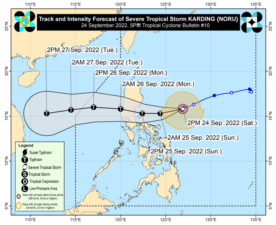
Severe Tropical Storm Karding forecast track. PAGASA
Areas under Signal No. 2 may experience gale-force winds, while strong winds will also experienced in places under Signal No. 1, PAGASA said.
ADVERTISEMENT
Light to moderate with at times heavy rains are expected overnight over Batanes, Cagayan, Isabela, the northern portion of Aurora, Catanduanes, Camarines Norte, and Camarines Sur.
From Sunday until Monday, Aurora, Nueva Ecija, Tarlac, Pangasinan, and the northern portion of Zambales will also experience heavy to intense with at times torrential rains, while the rest of Central Luzon will have moderate to heavy with at times intense rains.
Moderate to heavy rains are also expected over Metro Manila, Cagayan, Isabela, Quirino, Nueva Vizcaya, Cordillera Administrative Region, Ilocos Provinces, La Union, and Calabarzon due to the effects of Karding, PAGASA said.
"Under these conditions, scattered flooding and rain-induced landslides are possible, especially in areas that are highly or very highly susceptible to these hazard as identified in hazard maps and in localities with significant antecedent rainfall," it added.
Karding is also forecast to intensify into a typhoon in the next 12 hours and may strengthen further before landfall.
While it may weaken slightly as it traverses central Luzon, it is likely that Karding will remain a typhoon while crossing the country's landmass, PAGASA said.
The state weather bureau last estimated the eye of Karding at 475 kilometers east of Casiguran, Aurora, packing maximum sustained winds of 110 kilometers per hour and gustiness of up to 135 kilometers per hour. It is moving west southwestward at 25 kilometers per hour.
ABS-CBN is the leading media and entertainment company in the Philippines, offering quality content across TV, radio, digital, and film. Committed to public service and promoting Filipino values, ABS-CBN continues to inspire and connect audiences worldwide.
Our website is made possible by displaying online
advertisements to our visitors. Please consider supporting
us by disabling your ad blocker on our website.
Our website is made possible by displaying online
advertisements to our visitors. Please consider supporting
us by disabling your ad blocker on our website.