'Ferdie' maintains strength; 'Gener' enters PAR | ABS-CBN


Welcome, Kapamilya! We use cookies to improve your browsing experience. Continuing to use this site means you agree to our use of cookies. Tell me more!
'Ferdie' maintains strength; 'Gener' enters PAR
'Ferdie' maintains strength; 'Gener' enters PAR
Aaron Lozada,
ABS-CBN News
Published Sep 14, 2016 07:16 AM PHT
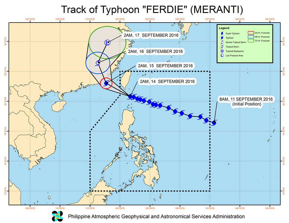
MANILA - State weather bureau PAGASA said Wednesday morning that warning signal no. 4 remains hoisted over the Batanes group of islands as Typhoon Ferdie made landfall in the area.
MANILA - State weather bureau PAGASA said Wednesday morning that warning signal no. 4 remains hoisted over the Batanes group of islands as Typhoon Ferdie made landfall in the area.
PAGASA said warning signal no. 3 is up in the Babuyan group of islands, while signal no. 2 is up in Ilocos Norte, Apayao and northern Cagayan.
PAGASA said warning signal no. 3 is up in the Babuyan group of islands, while signal no. 2 is up in Ilocos Norte, Apayao and northern Cagayan.
Meanwhile, tropical cyclone warning signal no. 1 is up in the rest of Cagayan, Kalinga, Abra and northern Ilocos Sur.
Meanwhile, tropical cyclone warning signal no. 1 is up in the rest of Cagayan, Kalinga, Abra and northern Ilocos Sur.
In a weather bulletin issued at 5:00 a.m., PAGASA said Ferdie was packing maximum sustained winds of up to 220 kilometers per hour and gusts of 255 kph.
In a weather bulletin issued at 5:00 a.m., PAGASA said Ferdie was packing maximum sustained winds of up to 220 kilometers per hour and gusts of 255 kph.
ADVERTISEMENT
It is expected to move west-northwest at 22 kph.
It is expected to move west-northwest at 22 kph.
The eye of Typhoon Ferdie was located 45 kilometers northwest of Itbayat, Batanes at 4 a.m. Wednesday.
The eye of Typhoon Ferdie was located 45 kilometers northwest of Itbayat, Batanes at 4 a.m. Wednesday.
Residents in northern Luzon were advised to take precautionary measures against impacts of very strong winds and heavy rainfall.
Residents in northern Luzon were advised to take precautionary measures against impacts of very strong winds and heavy rainfall.
Areas under warning signals were warned of possible storm surge in coastal areas.
Areas under warning signals were warned of possible storm surge in coastal areas.
PAGASA expects Ferdie to leave the Philippine area of responsibility (PAR) between 10 a.m. to 12 p.m. Wednesday.
PAGASA expects Ferdie to leave the Philippine area of responsibility (PAR) between 10 a.m. to 12 p.m. Wednesday.
Meanwhile, another typhoon has entered PAR.
Meanwhile, another typhoon has entered PAR.
Typhoon Gener was packing maximum sustained winds of up to 130 kph and gusts of 160 kph. It is expected to move west-northwest at 24 kph.
Typhoon Gener was packing maximum sustained winds of up to 130 kph and gusts of 160 kph. It is expected to move west-northwest at 24 kph.
Gener is also expected to enhance the rains brought by the southwest monsoon (habagat).
Gener is also expected to enhance the rains brought by the southwest monsoon (habagat).
Despite being inside the PAR at the same time, Ferdie and Gener will not have an effect on each other.
Despite being inside the PAR at the same time, Ferdie and Gener will not have an effect on each other.
ADVERTISEMENT
ADVERTISEMENT