Mangkhut now a supertyphoon: JTWC | ABS-CBN


Welcome, Kapamilya! We use cookies to improve your browsing experience. Continuing to use this site means you agree to our use of cookies. Tell me more!
Mangkhut now a supertyphoon: JTWC
Mangkhut now a supertyphoon: JTWC
Gillan Ropero and Patrick Quintos,
ABS-CBN News
Published Sep 11, 2018 05:50 PM PHT
|
Updated Sep 11, 2018 10:15 PM PHT
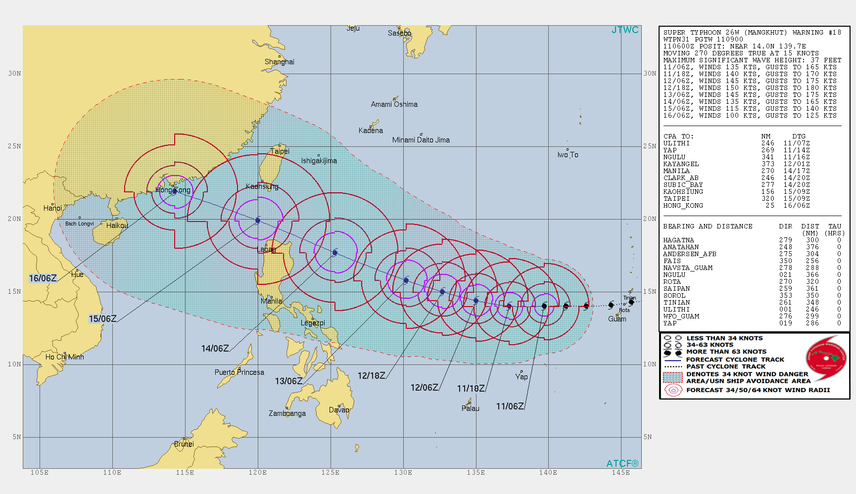
MANILA (UPDATE) - Typhoon Mangkhut has intensified into a supertyphoon, the US Joint Typhoon Warning Center (JTWC) said Tuesday.
MANILA (UPDATE) - Typhoon Mangkhut has intensified into a supertyphoon, the US Joint Typhoon Warning Center (JTWC) said Tuesday.
It is currently packing 250 kilometers per hour maximum sustained winds and gusts reaching 306 kph, according to one-minute readings made by the U.S. Navy-Air Force command based in Hawaii.
It is currently packing 250 kilometers per hour maximum sustained winds and gusts reaching 306 kph, according to one-minute readings made by the U.S. Navy-Air Force command based in Hawaii.
State weather bureau PAGASA, however, said the storm is only packing maximum sustained winds of 185 kph with gusts of up to 225 kph.
State weather bureau PAGASA, however, said the storm is only packing maximum sustained winds of 185 kph with gusts of up to 225 kph.
As of 3 p.m., Mangkhut was located 1,650 km east of Southern Luzon, outside the Philippine area of responsibility, according to state weather bureau PAGASA.
As of 3 p.m., Mangkhut was located 1,650 km east of Southern Luzon, outside the Philippine area of responsibility, according to state weather bureau PAGASA.
ADVERTISEMENT
It is forecast to enter PAR on Wednesday afternoon if it continues to move west at 30 kph.
It is forecast to enter PAR on Wednesday afternoon if it continues to move west at 30 kph.
The storm will be named Ompong once it enters PAR.
The storm will be named Ompong once it enters PAR.
The typhoon remains on track to threaten Northern Luzon and may traverse the Cagayan - Batanes area.
The typhoon remains on track to threaten Northern Luzon and may traverse the Cagayan - Batanes area.
It is expected to enhance the southwest monsoon, bringing scattered light to moderate rains over Zamboanga peninsula”, Western Visayas, and Palawan starting Thursday.
It is expected to enhance the southwest monsoon, bringing scattered light to moderate rains over Zamboanga peninsula”, Western Visayas, and Palawan starting Thursday.
The National Disaster Risk Reduction and Management Council on Tuesday morning already raised the highest alert in a 3-step system as Mangkhut continues towards PAR.
The National Disaster Risk Reduction and Management Council on Tuesday morning already raised the highest alert in a 3-step system as Mangkhut continues towards PAR.
Under the red alert, all concerned agencies are tasked to prepare for typhoon and send representatives to the NDRRMC headquarters, said its spokesperson Edgar Posadas.
Under the red alert, all concerned agencies are tasked to prepare for typhoon and send representatives to the NDRRMC headquarters, said its spokesperson Edgar Posadas.
PREPARING FOR YOLANDA-LEVEL
Earlier in the day, disaster officials said they have been preparing for a scenario similar to that of super typhoon Yolanda (Haiyan) as typhoon Mangkhut nears the Philippine area of responsibility.
Earlier in the day, disaster officials said they have been preparing for a scenario similar to that of super typhoon Yolanda (Haiyan) as typhoon Mangkhut nears the Philippine area of responsibility.
While Mangkhut is not the same as Yolanda in magnitude, they said, the typhoon continues to gain strength.
While Mangkhut is not the same as Yolanda in magnitude, they said, the typhoon continues to gain strength.
"Ang preparation natin ay level ng Yolanda. We have learned a lot after Yolanda." said Edgar Posadas, National Disaster Risk Reduction and Management Council spokesman. (Our preparation is Yolanda-level.)
"Ang preparation natin ay level ng Yolanda. We have learned a lot after Yolanda." said Edgar Posadas, National Disaster Risk Reduction and Management Council spokesman. (Our preparation is Yolanda-level.)
"Hindi naman ibig sabihin na Mangkhut isa the same level as Yolanda pero anything can happen kasi lumalakas pa siya habang lumalapit sa PAR," he added.
"Hindi naman ibig sabihin na Mangkhut isa the same level as Yolanda pero anything can happen kasi lumalakas pa siya habang lumalapit sa PAR," he added.
(That doesn't mean, though, that Mangkhut and Yolanda are in the same level but anything can happen because the typhoon continues to intensify as it nears PAR)
(That doesn't mean, though, that Mangkhut and Yolanda are in the same level but anything can happen because the typhoon continues to intensify as it nears PAR)
Posadas said Mangkhut will intensify the southwest monsoon (habagat) which will cause rains over Cagayan, Isabela, Apayao, Kalinga. Abra, Ilocos Norte, Batanes and the Babuyan islands.
Posadas said Mangkhut will intensify the southwest monsoon (habagat) which will cause rains over Cagayan, Isabela, Apayao, Kalinga. Abra, Ilocos Norte, Batanes and the Babuyan islands.
He said a P1.7-billion augmentation fund for relief aid from the Department of Social Welfare and Development was on standby for these areas.
He said a P1.7-billion augmentation fund for relief aid from the Department of Social Welfare and Development was on standby for these areas.
The NDRRMC official said telecommunication companies also committed to provide emergency lines in case there are power or signal outages.
The NDRRMC official said telecommunication companies also committed to provide emergency lines in case there are power or signal outages.
Regional disaster officials also assured that there are still enough rice and other food items especially because Tuesday's good weather allowed authorities to pre-position supplies, he added.
Regional disaster officials also assured that there are still enough rice and other food items especially because Tuesday's good weather allowed authorities to pre-position supplies, he added.
Posadas said because the diameter of the typhoon measures around 600 kilometers, its outer bands may also affect Metro Manila in the coming days.
Posadas said because the diameter of the typhoon measures around 600 kilometers, its outer bands may also affect Metro Manila in the coming days.
ADVERTISEMENT
ADVERTISEMENT