'Liwayway' continues to intensify as it moves north | ABS-CBN


ADVERTISEMENT

Welcome, Kapamilya! We use cookies to improve your browsing experience. Continuing to use this site means you agree to our use of cookies. Tell me more!
'Liwayway' continues to intensify as it moves north
'Liwayway' continues to intensify as it moves north
ABS-CBN News
Published Sep 03, 2019 05:48 PM PHT
|
Updated Sep 04, 2019 12:03 AM PHT
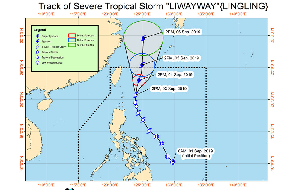
MANILA - Severe tropical storm Liwayway further intensified as it moved northward, the state weather bureau said Tuesday.
MANILA - Severe tropical storm Liwayway further intensified as it moved northward, the state weather bureau said Tuesday.
As of 4 p.m., Liwayway was last seen 225 kilometers (km) east of Basco, Batanes, packing maximum sustained winds of 110 km per hour (kph) and gusts of up to 135 kph.
As of 4 p.m., Liwayway was last seen 225 kilometers (km) east of Basco, Batanes, packing maximum sustained winds of 110 km per hour (kph) and gusts of up to 135 kph.
It picked up speed, now moving north at 15 kph.
It picked up speed, now moving north at 15 kph.
Tropical cyclone wind signal number 1 is still hoisted over Batanes as the storm continued to dampen parts of northern Luzon, PAGASA said.
Tropical cyclone wind signal number 1 is still hoisted over Batanes as the storm continued to dampen parts of northern Luzon, PAGASA said.
ADVERTISEMENT
The storm will bring light to moderate with intermittent heavy rains over Batanes, Apayao, and Cagayan, including Babuyan Islands.
The storm will bring light to moderate with intermittent heavy rains over Batanes, Apayao, and Cagayan, including Babuyan Islands.
Metro Manila, Ilocos region, Central Luzon, CALABARZON, Mindoro provinces, northern portions of Palawan (including Calamian Islands) and the rest of Cordillera Administrative Region will experience light to moderate, with at times heavy, monsoon rains.
Metro Manila, Ilocos region, Central Luzon, CALABARZON, Mindoro provinces, northern portions of Palawan (including Calamian Islands) and the rest of Cordillera Administrative Region will experience light to moderate, with at times heavy, monsoon rains.
The country's 12th storm this year is expected to leave the Philippine area of responsibility as a typhoon late Wednesday or early Thursday.
The country's 12th storm this year is expected to leave the Philippine area of responsibility as a typhoon late Wednesday or early Thursday.
Visit the ABS-CBN Weather Center for the latest weather updates.
Visit the ABS-CBN Weather Center for the latest weather updates.
ADVERTISEMENT
ADVERTISEMENT