Welcome, Kapamilya! We use cookies to improve your browsing experience. Continuing to use this site means you agree to our use of cookies. Tell me more!
'Gorio' to exit PAR Sunday, new tropical storm may enter: PAGASA
'Gorio' to exit PAR Sunday, new tropical storm may enter: PAGASA
ABS-CBN News
Published Jul 29, 2017 05:52 PM PHT
|
Updated Jul 30, 2017 08:57 AM PHT
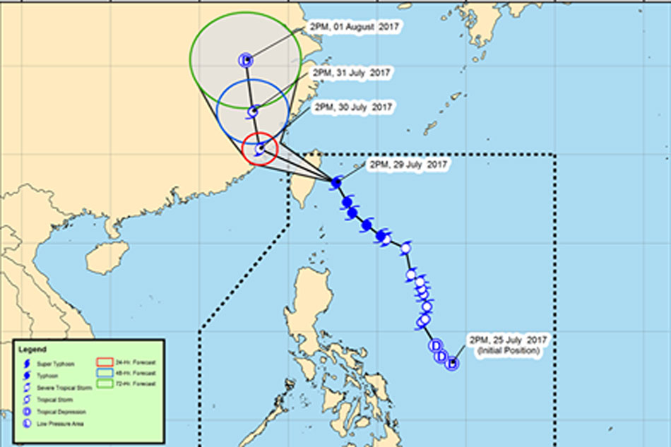
Track of Typhoon "Gorio." Photo courtesy of PAGASA Facebook page
MANILA- Typhoon "Gorio" is expected to make landfall in Taiwan Saturday night and exit the Philippine Area of Responsibility (PAR) by Sunday morning while another weather disturbance may immediately follow in its wake, state weather bureau PAGASA said Saturday.
In its 5 p.m. weather bulletin, PAGASA said Gorio has slightly accelerated and is forecast to move northwest at 19 kph, headed for landfall in Taiwan around 6 p.m Saturday.
Gorio packs maximum sustained winds of up to 145 kph and gustiness of up to 180 kph, maintaining its strength as it grazed the northeastern part of the Philippines.
It was last located at 60 kms north of Basco, Batanes.
ADVERTISEMENT
Moderate to heavy rains are expected within the 500-km diameter of the typhoon. Tropical Cyclone Warning Signal No. 1 is raised over the Batanes group of islands.
Meanwhile, the tropical depression just outside PAR has intensified into a tropical storm and may enter the country's northwestern boundary either on Sunday afternoon or evening, PAGASA said.
The tropical storm with international name "Haitang" will be named "Huaning" once it enters PAR, the weather bureau said.
Haitang was last located over the West Philippine Sea at 370 kms west of Laoag City, Ilocos Norte. It has maximum sustained winds of 90 km/h near the center and gustiness of up to 115 km/h.
Haitang is forecast to move northeast at 20 km/h.
Both Gorio and Haitang will continue to enhance the southwest monsoon, bringing moderate to occasionally heavy rains over the western section of Northern and Central Luzon.
PAGASA also advised against sea travel over the seaboards of Northern Luzon and the western seaboard of Central and Southern Luzon.
ABS-CBN is the leading media and entertainment company in the Philippines, offering quality content across TV, radio, digital, and film. Committed to public service and promoting Filipino values, ABS-CBN continues to inspire and connect audiences worldwide.
Our website is made possible by displaying online
advertisements to our visitors. Please consider supporting
us by disabling your ad blocker on our website.
Our website is made possible by displaying online
advertisements to our visitors. Please consider supporting
us by disabling your ad blocker on our website.