Signal No. 1 up over Batanes Group of Islands | ABS-CBN


ADVERTISEMENT

Welcome, Kapamilya! We use cookies to improve your browsing experience. Continuing to use this site means you agree to our use of cookies. Tell me more!
Signal No. 1 up over Batanes Group of Islands
Signal No. 1 up over Batanes Group of Islands
ABS-CBN News
Published Jul 06, 2016 11:51 AM PHT
|
Updated Jul 06, 2016 06:02 PM PHT
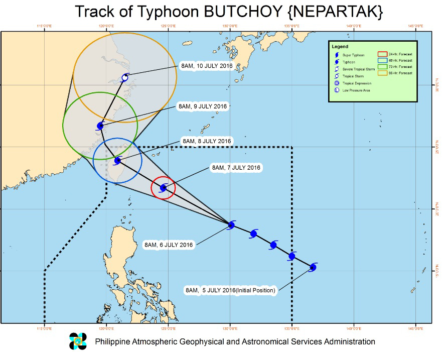
MANILA (UPDATED) - Typhoon Butchoy (international name: Nepartak) intensified further on Wednesday, prompting the state weather bureau to raise storm warning signal no. 1 over the Batanes Group of Islands.
MANILA (UPDATED) - Typhoon Butchoy (international name: Nepartak) intensified further on Wednesday, prompting the state weather bureau to raise storm warning signal no. 1 over the Batanes Group of Islands.
In its 11 a.m. weather bulletin, PAGASA said Butchoy was last spotted 860 kilometers east of Calayan, Cagayan, packing maximum sustained winds of 195 kilometers per hour (kph) near the center and gustiness of up to 230 kph.
In its 11 a.m. weather bulletin, PAGASA said Butchoy was last spotted 860 kilometers east of Calayan, Cagayan, packing maximum sustained winds of 195 kilometers per hour (kph) near the center and gustiness of up to 230 kph.
PAGASA said Butchoy was moving northwest at 30 kph.
PAGASA said Butchoy was moving northwest at 30 kph.
Butchoy was not expected to make landfall in the country, but it will enhance the habagat or southwest monsoon, which will bring rains over western parts of Luzon and Visayas.
Butchoy was not expected to make landfall in the country, but it will enhance the habagat or southwest monsoon, which will bring rains over western parts of Luzon and Visayas.
ADVERTISEMENT
But PAGASA weather division chief Esperanza Cayanan said habagat rains are not expected to be as strong as those experienced by the country back in 2012 and 2013.
But PAGASA weather division chief Esperanza Cayanan said habagat rains are not expected to be as strong as those experienced by the country back in 2012 and 2013.
Cayanan said they continue to monitor the weather disturbance.
Cayanan said they continue to monitor the weather disturbance.
Butchoy was forecast to be 305 kms east northeast of Itbayat, Batanes on Thursday morning and out of the Philippine area of responsibility by Saturday morning.
Butchoy was forecast to be 305 kms east northeast of Itbayat, Batanes on Thursday morning and out of the Philippine area of responsibility by Saturday morning.
Estimated rainfall amount is from moderate to heavy within the 550-kilometer diameter of the typhoon.
Estimated rainfall amount is from moderate to heavy within the 550-kilometer diameter of the typhoon.
The weather bureau also urged fishermen to refrain from venturing to the northern and eastern seaboards of Luzon. - With a report from Atom Araullo, ABS-CBN News
The weather bureau also urged fishermen to refrain from venturing to the northern and eastern seaboards of Luzon. - With a report from Atom Araullo, ABS-CBN News
ADVERTISEMENT
ADVERTISEMENT