Tropical depression Emong is here: Storm signal no.1 up in Batanes, Cagayan | ABS-CBN


Welcome, Kapamilya! We use cookies to improve your browsing experience. Continuing to use this site means you agree to our use of cookies. Tell me more!
Tropical depression Emong is here: Storm signal no.1 up in Batanes, Cagayan
Tropical depression Emong is here: Storm signal no.1 up in Batanes, Cagayan
ABS-CBN News
Published Jul 04, 2021 10:46 AM PHT
|
Updated Jul 04, 2021 12:38 PM PHT
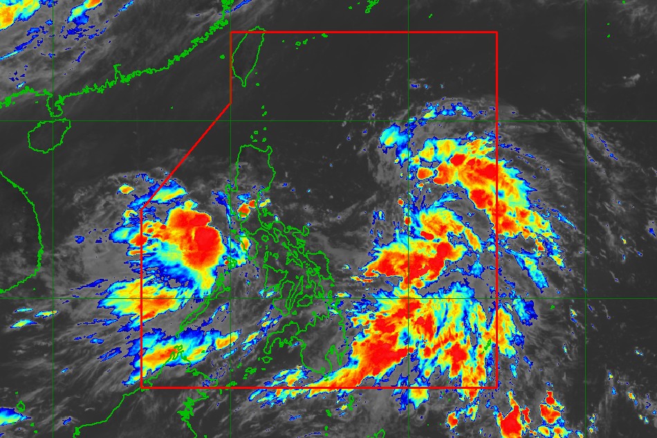
MANILA (UPDATE) - Tropical cyclone wind signal no. 1 was raised in Batanes and Cagayan after a low pressure area off Eastern Samar developed into tropical depression Emong on Sunday morning, the state weather bureau said.
MANILA (UPDATE) - Tropical cyclone wind signal no. 1 was raised in Batanes and Cagayan after a low pressure area off Eastern Samar developed into tropical depression Emong on Sunday morning, the state weather bureau said.
The country's fifth storm was last estimated 700 kilometers east northeast of Guiuan, Eastern Samar as of 10 a.m., moving northwest at 25 km per hour.
The country's fifth storm was last estimated 700 kilometers east northeast of Guiuan, Eastern Samar as of 10 a.m., moving northwest at 25 km per hour.
It was packing maximum winds of 45 kph near the center with gusts of up to 55 kph, PAGASA said in its 11 a.m. bulletin.
It was packing maximum winds of 45 kph near the center with gusts of up to 55 kph, PAGASA said in its 11 a.m. bulletin.
Emong is expected to remain as a tropical depression throughout the forecast period, according to the weather bureau.
Emong is expected to remain as a tropical depression throughout the forecast period, according to the weather bureau.
ADVERTISEMENT
It is projected to move northwestward until Monday morning and may traverse over the area of Batanes and Babuyan Islands between Monday evening and Tuesday morning, according to PAGASA.
It is projected to move northwestward until Monday morning and may traverse over the area of Batanes and Babuyan Islands between Monday evening and Tuesday morning, according to PAGASA.
Tropical cyclone wind signal no. 1, which may bring 30 to 60 kph winds in 36 hours and cause slight damage to houses made of very light materials or makeshift structures in exposed communities, was raised over the following areas:
Tropical cyclone wind signal no. 1, which may bring 30 to 60 kph winds in 36 hours and cause slight damage to houses made of very light materials or makeshift structures in exposed communities, was raised over the following areas:
- Batanes
- northeastern portion of Cagayan (Santa Ana, Gonzaga) including Babuyan Islands.
- Batanes
- northeastern portion of Cagayan (Santa Ana, Gonzaga) including Babuyan Islands.
Another brewing storm was spotted 120 km east of Calapan City, Oriental Mindoro, which might develop into tropical storm Fabian, PAGASA weather specialist Aldczar Aurelio said.
Another brewing storm was spotted 120 km east of Calapan City, Oriental Mindoro, which might develop into tropical storm Fabian, PAGASA weather specialist Aldczar Aurelio said.
The storms will bring scattered rains and thunderstorms over Metro Manila, Quirino, Nueva Vizcaya, Central Luzon, Calabarzon, Mimaropa, Bicol region, Visayas, and Mindanao, according to the weather bureau's earlier advisory.
The storms will bring scattered rains and thunderstorms over Metro Manila, Quirino, Nueva Vizcaya, Central Luzon, Calabarzon, Mimaropa, Bicol region, Visayas, and Mindanao, according to the weather bureau's earlier advisory.
The rest of Luzon will experience partly cloudy to cloudy skies with isolated rains due to localized thunderstorms.
The rest of Luzon will experience partly cloudy to cloudy skies with isolated rains due to localized thunderstorms.
RELATED VIDEO
Read More:
weather
weather top
weather forecast
Philippine weather
PAGASA
tropical depression Emong
EmongPH
LPA
low pressure area
Bagyo 2021
ADVERTISEMENT
ADVERTISEMENT