Welcome, Kapamilya! We use cookies to improve your browsing experience. Continuing to use this site means you agree to our use of cookies. Tell me more!
Weather disturbance outside Philippines now a super typhoon: PAGASA
Weather disturbance outside Philippines now a super typhoon: PAGASA
ABS-CBN News
Published May 23, 2023 05:44 PM PHT
|
Updated May 24, 2023 07:44 AM PHT
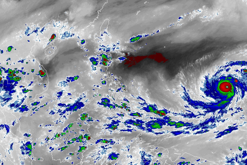
RAMMB/US NOAA/Himawari 8
MANILA — The weather disturbance outside the Philippine area of responsibility further intensified into a super typhoon on Tuesday, the state weather bureau said.
In its 4 p.m. bulletin, PAGASA said super typhoon Mawar was last spotted 2,285 kilometers east of Visayas at 3 p.m., packing maximum sustained winds of up to 185 kilometers per hour near the center and 230 kph gusts.
While Mawar has no direct effect on the country’s weather yet, it may enter PAR by Friday or Saturday, the weather agency said.
Mawar is also expected to enhance the southwesterly windflow, which could bring rains to the western parts of Visayas and Mindanao.
ADVERTISEMENT
It is also not expected to hit land in the Philippines, but PAGASA will continue monitoring its movement.
Meanwhile, the southwesterly windflow is currently affecting western sections of southern Luzon, Visayas and Mindanao, while a frontal system is affecting extreme northern Luzon.
Batanes and Babuyan Islands may experience cloudy skies with rains, while Palawan may also experience cloudy skies with scattered rainshowers and thunderstorms.
Metro Manila and the rest of the country could expect partly cloudy to cloudy skies with isolated rainshowers or thunderstorms.
ABS-CBN is the leading media and entertainment company in the Philippines, offering quality content across TV, radio, digital, and film. Committed to public service and promoting Filipino values, ABS-CBN continues to inspire and connect audiences worldwide.
Our website is made possible by displaying online
advertisements to our visitors. Please consider supporting
us by disabling your ad blocker on our website.
Our website is made possible by displaying online
advertisements to our visitors. Please consider supporting
us by disabling your ad blocker on our website.