Welcome, Kapamilya! We use cookies to improve your browsing experience. Continuing to use this site means you agree to our use of cookies. Tell me more!
Crising maintains strength, heads for Davao Oriental, Surigao del Sur
Crising maintains strength, heads for Davao Oriental, Surigao del Sur
Job Manahan,
ABS-CBN News
Published May 13, 2021 06:17 PM PHT
|
Updated May 13, 2021 09:03 PM PHT
Photo courtesy of PAGASA
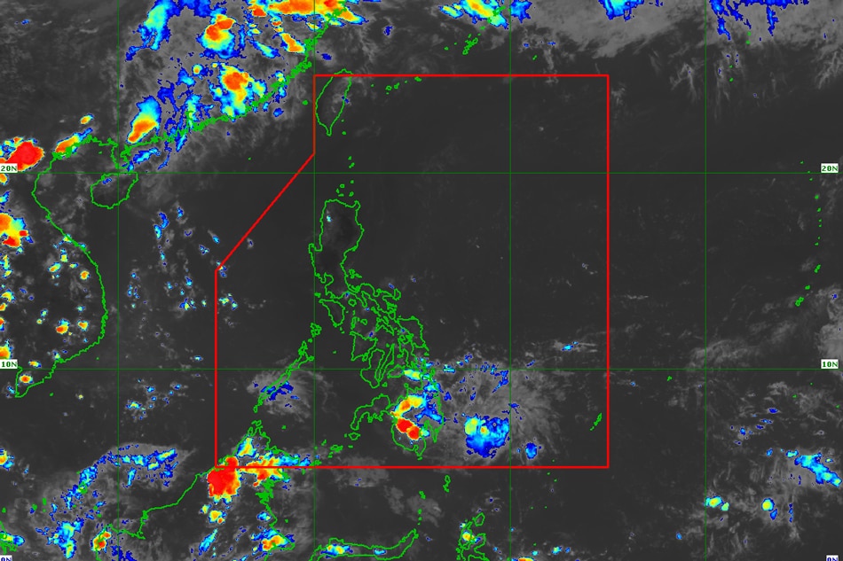
MANILA— Tropical Storm Crising on Thursday afternoon maintained its strength and is moving closer to Davao Oriental and Surigao del Sur, the state weather bureau said.
In its latest weather bulletin, PAGASA said "Crising" was last spotted 150 kilometers southeast of Hinatuan, Surigao del Sur at 4 p.m., moving west northwestward at 25 kilometers per hour (kph).
The country's 3rd storm this year has maximum sustained winds of 65 kph near the center with gusts of up to 80 kph.
According to the weather agency, Crising may hit land between Thursday night and Friday morning somewhere over Davao Oriental and Surigao del Sur and is forecast to remain as a tropical storm prior to landfall.
ADVERTISEMENT
It is then expected to weaken as it crosses land.
"'Crising' is forecast to weaken into a tropical depression as it traverses the rugged landmass of Mindanao and will emerge over the Sulu Sea on Saturday," said PAGASA.
The following areas were placed under tropical cyclone wind signal no. 2, where winds of 61 to 120 kph may be expected in 24 hours and might blow off old galvanized iron roofs and down wooden, old electric posts:
MINDANAO
Southern portion of Surigao del Sur (Tagbina, Hinatuan, City of Bislig, Lingig, Barobo)
Southern portion of Agusan del Sur (Loreto, La Paz, Rosario, Bunawan, Veruela, Santa Josefa, Trento, San Francisco, Talacogon)
Northern portion of Davao Oriental (Boston, Cateel, Baganga)
Northern portion of Davao de Oro (Laak, Monkayo, Montevista, Compostela, New Bataan, Nabunturan,Mawab)
Northern portion of Davao del Norte (Kapalong, San Isidro, Asuncion, New Corella, Talaingod)
Tropical cyclone wind signal no.1, which may cause slight damage to some houses made of very light materials or makeshift structures, remains hoisted over the following areas:
VISAYAS
Southeastern portion of Negros Oriental (Dumaguete City, Valencia, Sibulan, Santa Catalina, Siaton, Zamboanguita, Dauin, Bacong)
Siquijor
MINDANAO
Surigao del Norte including Bucas Grande and Siargao Islands
The rest of Surigao del Sur
The rest of Agusan del Sur
Agusan del Norte
The rest of Davao Oriental
The rest of Davao de Oro
The rest of Davao del Norte
Davao City
Bukidnon
Lanao del Sur
Lanao del Norte
Misamis Occidental
Misamis Oriental
Camiguin
The northeastern portion of Zamboanga del Sur (Midsalip, Sominot, Dumingag, Molave, Mahayag, Josefina, Tambulig, Ramon Magsaysay, Aurora, Tukuran, Labangan)
The northeastern portion of Zamboanga del Norte (Sergio Osmeña Sr., Katipunan, Pres. Manuel A. Roxas, Jose Dalman, Manukan, Dipolog City, Polanco, Piñan, Mutia, Dapitan City, Sibutad, Rizal, La Libertad)
ABS-CBN is the leading media and entertainment company in the Philippines, offering quality content across TV, radio, digital, and film. Committed to public service and promoting Filipino values, ABS-CBN continues to inspire and connect audiences worldwide.
Our website is made possible by displaying online
advertisements to our visitors. Please consider supporting
us by disabling your ad blocker on our website.
Our website is made possible by displaying online
advertisements to our visitors. Please consider supporting
us by disabling your ad blocker on our website.