What to expect after the Lanao del Sur quake | ABS-CBN


ADVERTISEMENT

Welcome, Kapamilya! We use cookies to improve your browsing experience. Continuing to use this site means you agree to our use of cookies. Tell me more!
What to expect after the Lanao del Sur quake
What to expect after the Lanao del Sur quake
ABS-CBN News
Published Apr 13, 2017 06:42 PM PHT
|
Updated Apr 13, 2017 08:04 PM PHT
ABS-CBN News is publishing this primer from the Philippine Institute of Volcanology and Seismology (Phivolcs) on the magnitude 6.0 earthquake, which struck Lanao del Sur on Wednesday.
What is happening in Lanao del Sur?
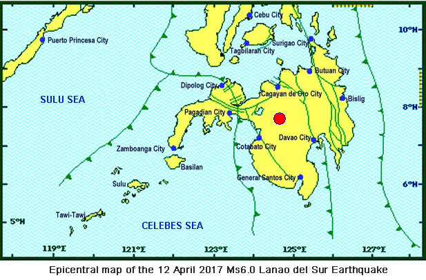
At 5:21 a.m. on April 12, 2017, Wednesday, a Magnitude 6 earthquake shook Mindanao. The epicenter was located 13 kilometers northwest of Wao, Lanao del Sur, at a depth of 1 km.
At 5:21 a.m. on April 12, 2017, Wednesday, a Magnitude 6 earthquake shook Mindanao. The epicenter was located 13 kilometers northwest of Wao, Lanao del Sur, at a depth of 1 km.
The movement of a northwest trending active fault in the area generated the earthquake. Small-magnitude earthquakes followed, and as of 3 p.m. Wednesday, the Phivolcs seismic monitoring network recorded 73 aftershocks.
The movement of a northwest trending active fault in the area generated the earthquake. Small-magnitude earthquakes followed, and as of 3 p.m. Wednesday, the Phivolcs seismic monitoring network recorded 73 aftershocks.
Based on preliminary intensity reports, the strongest ground shaking was felt at Phivolcs Earthquake Intensity Scale (PEIS) VII (Destructive) in Wao, Lanao del Sur and Kalilangan, Bukidnon. Furthermore, it was felt at PEIS VI (Very Strong) in Amai Manabilang, Lanao del Sur; PEIS V (Strong) in Pangantukan, Bukidnon, and Banisilan, Cotabato.
Based on preliminary intensity reports, the strongest ground shaking was felt at Phivolcs Earthquake Intensity Scale (PEIS) VII (Destructive) in Wao, Lanao del Sur and Kalilangan, Bukidnon. Furthermore, it was felt at PEIS VI (Very Strong) in Amai Manabilang, Lanao del Sur; PEIS V (Strong) in Pangantukan, Bukidnon, and Banisilan, Cotabato.
It was also felt at PEIS IV in Cagayan de Oro City, Iligan City, Cotabato City, Gingoog City in Misamis Oriental, Matalam in North Cotabato, Valencia and Maramag in Bukidnon, and Davao City.
It was also felt at PEIS IV in Cagayan de Oro City, Iligan City, Cotabato City, Gingoog City in Misamis Oriental, Matalam in North Cotabato, Valencia and Maramag in Bukidnon, and Davao City.
ADVERTISEMENT
This was felt at PEIS III to I in Kabacan and Arakan in North Cotabato, Quezon and Don Carlos in Bukidnon, Pikit in Cotabato, Lebak in Sultan Kudarat, Kidapawan City, Koronadal City, and Mambajao in Camiguin.
This was felt at PEIS III to I in Kabacan and Arakan in North Cotabato, Quezon and Don Carlos in Bukidnon, Pikit in Cotabato, Lebak in Sultan Kudarat, Kidapawan City, Koronadal City, and Mambajao in Camiguin.
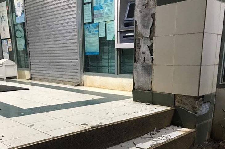
Damage to some buildings and roads due to strong ground shaking were reported near the epicenter. Landslides were also reported in Amai Manabilang (Bumbaran). There were no immediate reports of casualties.
Damage to some buildings and roads due to strong ground shaking were reported near the epicenter. Landslides were also reported in Amai Manabilang (Bumbaran). There were no immediate reports of casualties.
A strong earthquake has affected Lanao del Sur in the past
On April 1, 1955, a Magnitude 7.5 earthquake was experienced in the Lanao area. It claimed 400 lives.
On April 1, 1955, a Magnitude 7.5 earthquake was experienced in the Lanao area. It claimed 400 lives.
Strong ground shaking was also felt during this event, resulting in significant damage to infrastructure, including a mosque in Tugaya municipality near Lake Lanao. Several houses also collapsed, and wharves were damaged in Zamboanga City and Pagadian City. Liquefaction and landslides were also documented.
Strong ground shaking was also felt during this event, resulting in significant damage to infrastructure, including a mosque in Tugaya municipality near Lake Lanao. Several houses also collapsed, and wharves were damaged in Zamboanga City and Pagadian City. Liquefaction and landslides were also documented.
Aside from this, several small to moderate earthquakes were also recorded within the province, with intensities ranging from PEIS IV to VII.
Aside from this, several small to moderate earthquakes were also recorded within the province, with intensities ranging from PEIS IV to VII.
Why do earthquakes occur in Lanao del Sur?
Central Mindanao, including Lanao del Sur, is one of the seismically active areas in the country, because of the presence of the western extension of the Mindanao Fault (Cotabato-Sindangan Fault), an active fault that runs from Sarangani province to northwest of Zamboanga Peninsula. The Cotabato Trench is also a major source of earthquakes, which can affect the region. In addition, there exist other local active faults, which can be sources of small- to moderate-magnitude earthquakes.
Central Mindanao, including Lanao del Sur, is one of the seismically active areas in the country, because of the presence of the western extension of the Mindanao Fault (Cotabato-Sindangan Fault), an active fault that runs from Sarangani province to northwest of Zamboanga Peninsula. The Cotabato Trench is also a major source of earthquakes, which can affect the region. In addition, there exist other local active faults, which can be sources of small- to moderate-magnitude earthquakes.
Can present earthquakes indicate volcanic activity?
No. The origin of the April 12 magnitude 6.0 earthquake, and its subsequent aftershocks, are clearly tectonic.
No. The origin of the April 12 magnitude 6.0 earthquake, and its subsequent aftershocks, are clearly tectonic.
What can we expect from the current earthquake activity?
Current available seismic information suggest that the Magnitude 6 earthquake on April 12 was the main shock, which caused the strong ground shaking. The succeeding small-magnitude earthquakes were the aftershocks. The aftershocks may continue to occur for several days to weeks, some of which may be felt.
Current available seismic information suggest that the Magnitude 6 earthquake on April 12 was the main shock, which caused the strong ground shaking. The succeeding small-magnitude earthquakes were the aftershocks. The aftershocks may continue to occur for several days to weeks, some of which may be felt.
Aside from strong ground shaking, what other seismic hazards are life threatening?
Landslides, rock falls, and other types of mass movements may occur in mountainous or hilly areas.
Landslides, rock falls, and other types of mass movements may occur in mountainous or hilly areas.
Liquefaction, manifested by sand boils or lateral spread, may affect low-lying, waterlogged, sandy areas at the banks of rivers.
Liquefaction, manifested by sand boils or lateral spread, may affect low-lying, waterlogged, sandy areas at the banks of rivers.
Tsunamis are not expected because the source of the April 12 event is on land. The tsunami threat for Lanao del Sur would come from the movement of the Cotabato Trench, located south of the province.
Tsunamis are not expected because the source of the April 12 event is on land. The tsunami threat for Lanao del Sur would come from the movement of the Cotabato Trench, located south of the province.
However, Lake Lanao may be disturbed and may result to a phenomenon called seiche. Seiche is a temporary oscillation in an enclosed body of water such as lakes, caused by strong ground shaking. This phenomenon was observed during the 1955 magnitude 7.5 Lanao earthquake.
However, Lake Lanao may be disturbed and may result to a phenomenon called seiche. Seiche is a temporary oscillation in an enclosed body of water such as lakes, caused by strong ground shaking. This phenomenon was observed during the 1955 magnitude 7.5 Lanao earthquake.
What should be done by affected communities?
People should be cautious of houses and buildings and other structures visibly weakened, or with signs of damage by the April 12 earthquake, as these may be further damaged by aftershocks. In case of houses and other buildings with visible damage, it is best to contact the Municipal or City Engineering Office for advice.
People should be cautious of houses and buildings and other structures visibly weakened, or with signs of damage by the April 12 earthquake, as these may be further damaged by aftershocks. In case of houses and other buildings with visible damage, it is best to contact the Municipal or City Engineering Office for advice.
Engineers from the local government, other agencies, and organizations should inspect houses and other structures to determine their integrity, and recommend appropriate actions to concerned affected groups or individuals.
Engineers from the local government, other agencies, and organizations should inspect houses and other structures to determine their integrity, and recommend appropriate actions to concerned affected groups or individuals.
Slopes should be checked for tension cracks that may have resulted from the strong ground shaking. Tension cracks may make slopes more susceptible to landslides. These areas should also be avoided.
Slopes should be checked for tension cracks that may have resulted from the strong ground shaking. Tension cracks may make slopes more susceptible to landslides. These areas should also be avoided.
The best course of action is preparedness. In case of another felt earthquake, people should protect themselves by doing the “duck, cover and hold” precaution. In houses and offices, cabinets should be strapped to the walls, and appliances be secured to prevent them from toppling and causing injuries injury to persons.
The best course of action is preparedness. In case of another felt earthquake, people should protect themselves by doing the “duck, cover and hold” precaution. In houses and offices, cabinets should be strapped to the walls, and appliances be secured to prevent them from toppling and causing injuries injury to persons.
What is the role of Phivolcs?
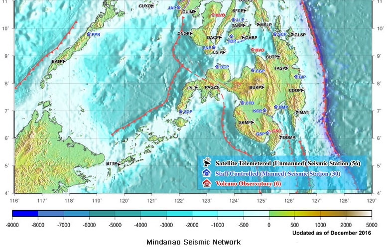
Phivolcs operates and maintains a network of 93 seismic stations spread across the Philippines. Eighteen of these seismic stations are located in Mindanao Island, eight of which are staffed-controlled and are located in Cotabato City, Kidapawan City, Cagayan De Oro City, Bislig City, Surigao City, Dipolog City, Zamboanga City, and General Santos City.
Phivolcs operates and maintains a network of 93 seismic stations spread across the Philippines. Eighteen of these seismic stations are located in Mindanao Island, eight of which are staffed-controlled and are located in Cotabato City, Kidapawan City, Cagayan De Oro City, Bislig City, Surigao City, Dipolog City, Zamboanga City, and General Santos City.
Phivolcs also has 10 remote seismic stations located in Pikit in Cotabato, Valencia in Bukidnon, Sultan Kudarat, Talacogon in Agusan del Sur, Butuan City, Don Marcelino in Davao Occidental, Mati and Cateel in Davao Oriental, Pagadian City and Ipil in Zamboanga Peninsula. Data from these seismic stations are used to determine the locations of earthquakes, as well as the characteristics of the earthquakes generated.
Phivolcs also has 10 remote seismic stations located in Pikit in Cotabato, Valencia in Bukidnon, Sultan Kudarat, Talacogon in Agusan del Sur, Butuan City, Don Marcelino in Davao Occidental, Mati and Cateel in Davao Oriental, Pagadian City and Ipil in Zamboanga Peninsula. Data from these seismic stations are used to determine the locations of earthquakes, as well as the characteristics of the earthquakes generated.
Aside from monitoring the occurrences of earthquakes, Phivolcs also provides the public with information on hazards analyses and assessments. As part of its mandate, Phivolcs works hand-in-hand with other government agencies in mitigating the damaging effects of earthquakes.
Aside from monitoring the occurrences of earthquakes, Phivolcs also provides the public with information on hazards analyses and assessments. As part of its mandate, Phivolcs works hand-in-hand with other government agencies in mitigating the damaging effects of earthquakes.
More information about recent earthquakes, volcanic activities and hazard maps can be obtained at the Phivolcs website (www.phivolcs.dost.gov.ph), Facebook page (www.facebook.com/PHIVOLCS), and Twitter account (@phivolcs_dost).
More information about recent earthquakes, volcanic activities and hazard maps can be obtained at the Phivolcs website (www.phivolcs.dost.gov.ph), Facebook page (www.facebook.com/PHIVOLCS), and Twitter account (@phivolcs_dost).
Earthquake observations may be reported to Phivolcs at telephone numbers (02) 929-9254 and (02) 426-1468 to 79, local 124 and 125.
Earthquake observations may be reported to Phivolcs at telephone numbers (02) 929-9254 and (02) 426-1468 to 79, local 124 and 125.
ADVERTISEMENT
ADVERTISEMENT