'Lawin' nears super typhoon status; signal no. 5 possible in 2 areas


ADVERTISEMENT

Welcome, Kapamilya! We use cookies to improve your browsing experience. Continuing to use this site means you agree to our use of cookies. Tell me more!
'Lawin' nears super typhoon status; signal no. 5 possible in 2 areas
Jamaine Punzalan,
ABS-CBN News
Published Oct 19, 2016 11:43 AM PHT
|
Updated Oct 19, 2016 04:39 PM PHT
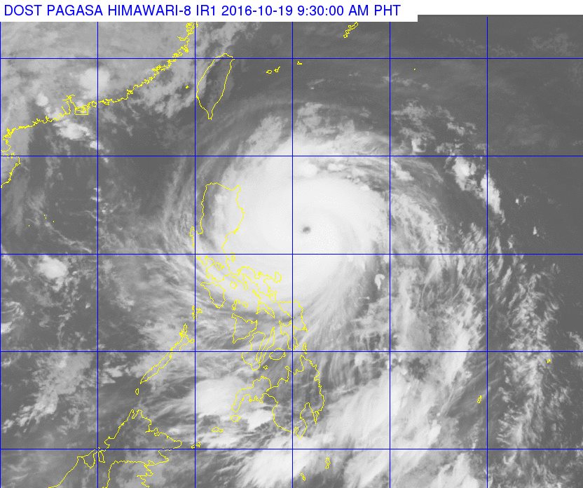
MANILA - (UPDATE) Potentially destructive cyclone ''Lawin'' is poised to reach super typhoon status as it continues to threaten northern Luzon, state weather agency PAGASA announced Wednesday morning.
MANILA - (UPDATE) Potentially destructive cyclone ''Lawin'' is poised to reach super typhoon status as it continues to threaten northern Luzon, state weather agency PAGASA announced Wednesday morning.
In an 11 a.m. briefing, PAGASA meteorologist Aldczar Aurelio said the typhoon was packing top sustained winds of 220 kilometers per hour (kph) near the center and gusts of 305 kph.
In an 11 a.m. briefing, PAGASA meteorologist Aldczar Aurelio said the typhoon was packing top sustained winds of 220 kilometers per hour (kph) near the center and gusts of 305 kph.
Lawin may further intensify into a super typhoon with maximum winds of at least 221 kph before it makes landfall in the vicinity of Isabela and Cagayan, Aurelio said.
Lawin may further intensify into a super typhoon with maximum winds of at least 221 kph before it makes landfall in the vicinity of Isabela and Cagayan, Aurelio said.
Isabela and Cagayan have been placed under tropical warning signal number 4. The signal may be upgraded one notch higher on Wednesday afternoon, Aurelio said.
Isabela and Cagayan have been placed under tropical warning signal number 4. The signal may be upgraded one notch higher on Wednesday afternoon, Aurelio said.
ADVERTISEMENT
"Magra-raise lang tayo ng signal number 5 kapat naging super typhoon [si Lawin], which is 221 kilometers per hour and above. One [kph] na lang po ang difference, magiging super typhoon na siya," he explained.
"Magra-raise lang tayo ng signal number 5 kapat naging super typhoon [si Lawin], which is 221 kilometers per hour and above. One [kph] na lang po ang difference, magiging super typhoon na siya," he explained.
The following ares were also placed under storm signals:
The following ares were also placed under storm signals:
Signal 3
Rest of Cagayan, Abra, Apayao, Ilocos Sur, Ilocos Norte, Mt. Province, Ifugao, Quirino, Kalinga and Northern Aurora
Signal 3
Rest of Cagayan, Abra, Apayao, Ilocos Sur, Ilocos Norte, Mt. Province, Ifugao, Quirino, Kalinga and Northern Aurora
Signal 2
Calayan Group of Islands, La Union, Benguet, Nueva Vizcaya, Pangasinan, Nueva Ecija, Aurora, and Tarlac
Signal 2
Calayan Group of Islands, La Union, Benguet, Nueva Vizcaya, Pangasinan, Nueva Ecija, Aurora, and Tarlac
Signal 1
Batanes Group of Islands, Zambales, Pampanga, Bulacan, Bataan, Northern Quezon including Polillo Islands, Metro Manila, Rizal, Cavite, Laguna, Camarines Norte, Camarines Sur, and Catanduanes
Signal 1
Batanes Group of Islands, Zambales, Pampanga, Bulacan, Bataan, Northern Quezon including Polillo Islands, Metro Manila, Rizal, Cavite, Laguna, Camarines Norte, Camarines Sur, and Catanduanes
ADVERTISEMENT
Lawin is expected to make landfall over the Isabela-Cagayan area between 11 p.m. Wednesday to 2 a.m. Thursday.
Lawin is expected to make landfall over the Isabela-Cagayan area between 11 p.m. Wednesday to 2 a.m. Thursday.
Other areas within the typhoon's 700-kilometer diameter will experience moderate to heavy and occasionally intense rains that may trigger landslides and flashfloods.
Other areas within the typhoon's 700-kilometer diameter will experience moderate to heavy and occasionally intense rains that may trigger landslides and flashfloods.
“Iyung bagyong ito, talagang super strong siya. Kahit saan tatama iyun, talagang destructive siya. Huwag niyo nang anuhin kung saan mag-landfall, kahit tatama siya ng Cagayan o Isabela, destructive pa rin siya dahil sa laki ng diameter ng bagyo natin,” said Rene Paciente, PAGASA Assistant Weather Services Chief.
“Iyung bagyong ito, talagang super strong siya. Kahit saan tatama iyun, talagang destructive siya. Huwag niyo nang anuhin kung saan mag-landfall, kahit tatama siya ng Cagayan o Isabela, destructive pa rin siya dahil sa laki ng diameter ng bagyo natin,” said Rene Paciente, PAGASA Assistant Weather Services Chief.
[This typhoon is really super strong. Wherever it hits, it will be destructive. Don’t focus on where it will make landfall because even it hits Cagayan or Isabela, it will be destructive in other areas because of the size of its diameter.]
Storm surges of up to five meters may also batter the coastal areas of Cagayan, Calayan islands, Isabela, Northern Aurora, and Ilocos Norte, Aurelio said.
Visit the ABS-CBN Weather Center for the latest weather updates.
Visit the ABS-CBN Weather Center for the latest weather updates.
ADVERTISEMENT
ADVERTISEMENT