Karen leaves PAR; Haima may become super typhoon | ABS-CBN


ADVERTISEMENT

Welcome, Kapamilya! We use cookies to improve your browsing experience. Continuing to use this site means you agree to our use of cookies. Tell me more!
Karen leaves PAR; Haima may become super typhoon
Karen leaves PAR; Haima may become super typhoon
Jamaine Punzalan,
ABS-CBN News
Published Oct 17, 2016 08:00 AM PHT
|
Updated Oct 17, 2016 12:14 PM PHT
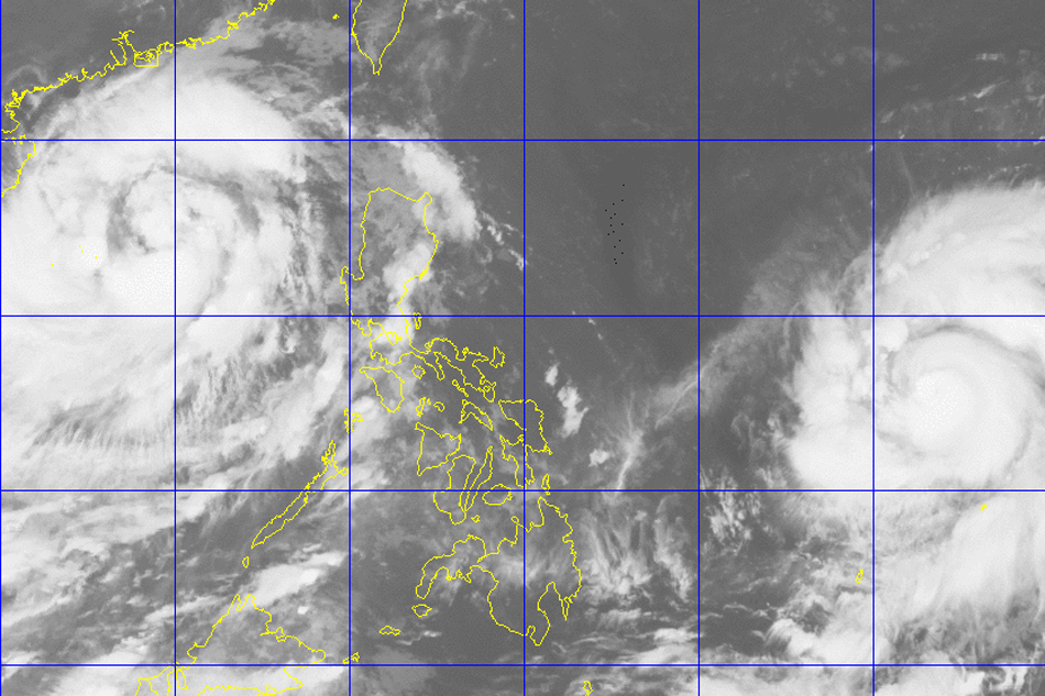
MANILA - Typhoon ''Karen'' has left the Philippine area of responsibility (PAR) early Monday, but another stronger cyclone is expected to pummel Luzon in the afternoon, state and foreign meteorologists reported.
MANILA - Typhoon ''Karen'' has left the Philippine area of responsibility (PAR) early Monday, but another stronger cyclone is expected to pummel Luzon in the afternoon, state and foreign meteorologists reported.
In its 5 a.m. bulletin, local weather agency PAGASA said Karen left PAR at past 12 a.m., barreling towards mainland China with top sustained winds of 130 kilometers per hour (kph) and gusts of up to 200 kph.
In its 5 a.m. bulletin, local weather agency PAGASA said Karen left PAR at past 12 a.m., barreling towards mainland China with top sustained winds of 130 kilometers per hour (kph) and gusts of up to 200 kph.
But even as it moves away from the Philippines, Karen will continue to dump occasionally moderate rains to Ilocos, Cordillera and Cagayan Valley regions, as well as Bataan and Zambales province, PAGASA meteorologist Meno Mendoza told radio DZMM
But even as it moves away from the Philippines, Karen will continue to dump occasionally moderate rains to Ilocos, Cordillera and Cagayan Valley regions, as well as Bataan and Zambales province, PAGASA meteorologist Meno Mendoza told radio DZMM
Typhoon "Haima," meanwhile, has intensified into a typhoon overnight and may continue to gain new muscle.
Typhoon "Haima," meanwhile, has intensified into a typhoon overnight and may continue to gain new muscle.
ADVERTISEMENT
"Inaasahan natin na posibleng lumakas pa habang papalapit sa ating bansa [We expect that it will get stronger as it approaches our country]," Mendoza said, adding that Haima is expected to enter PAR at around 4 p.m. Monday.
"Inaasahan natin na posibleng lumakas pa habang papalapit sa ating bansa [We expect that it will get stronger as it approaches our country]," Mendoza said, adding that Haima is expected to enter PAR at around 4 p.m. Monday.
As of 5 a.m., Haima was bearing maximum sustained winds of 140 kph and gusts of up to 175 kph. It was last tracked at 1,430 kilometers east of Visayas.
As of 5 a.m., Haima was bearing maximum sustained winds of 140 kph and gusts of up to 175 kph. It was last tracked at 1,430 kilometers east of Visayas.
The Weather Channel also reported that the typhoon "may reach super typhoon status before posing a threat to the northern Philippines."
The Weather Channel also reported that the typhoon "may reach super typhoon status before posing a threat to the northern Philippines."
#Haima could become a super typhoon in the western Pacific before threatening the Philippines: https://t.co/WeWpw6t7Eu pic.twitter.com/RD0aPh427f
— The Weather Channel (@weatherchannel) October 16, 2016
#Haima could become a super typhoon in the western Pacific before threatening the Philippines: https://t.co/WeWpw6t7Eu pic.twitter.com/RD0aPh427f
— The Weather Channel (@weatherchannel) October 16, 2016
The outflow of winds on top of Haima, low wind shear and warm, deep ocean water have set the stage for the typhoon's possible "rapid intensification" into a super typhoon, the American broadcaster explained.
The outflow of winds on top of Haima, low wind shear and warm, deep ocean water have set the stage for the typhoon's possible "rapid intensification" into a super typhoon, the American broadcaster explained.
PAGASA defines super typhoons as those "with maximum wind speed exceeding 220 kph or more than 120 knots." The deadliest and strongest on record, Super Typhoon Haiyan, destroyed entire towns in the central islands in November 2013, leaving more than 7,350 people dead or missing.
PAGASA defines super typhoons as those "with maximum wind speed exceeding 220 kph or more than 120 knots." The deadliest and strongest on record, Super Typhoon Haiyan, destroyed entire towns in the central islands in November 2013, leaving more than 7,350 people dead or missing.
Haima will be named "Lawin" once it enters PAR at around 4 p.m., Mendoza said. It is expected to make landfall in Cagayan.
Haima will be named "Lawin" once it enters PAR at around 4 p.m., Mendoza said. It is expected to make landfall in Cagayan.
The typhoon may trigger storm surges, floods, and landslides. It will also be especially damaging to Luzon areas that were earlier inundated by Karen, the Weather Channel warned.
The typhoon may trigger storm surges, floods, and landslides. It will also be especially damaging to Luzon areas that were earlier inundated by Karen, the Weather Channel warned.
Karen mmade landfall in Baler, Aurora early Sunday, toppling trees, cutting power lines and ripping off roofs.
Karen mmade landfall in Baler, Aurora early Sunday, toppling trees, cutting power lines and ripping off roofs.
The typhoon also forced over 2,000 families or 12,000 individuals to seek safer ground in Ilocos, Central Luzon, Calabarzon, and Bicol regions.
The typhoon also forced over 2,000 families or 12,000 individuals to seek safer ground in Ilocos, Central Luzon, Calabarzon, and Bicol regions.
Karen also disrupted air and sea travel, caused the cancellation of Monday classes in some provinces and damaged at least P53 million worth of crops.
Karen also disrupted air and sea travel, caused the cancellation of Monday classes in some provinces and damaged at least P53 million worth of crops.
Read More:
DZMM
weather
weather top
supertyphoon
Typhoon Haima
Typhoon Lawin
Typhoon Karen
storm signals
Weather Channel
weather alert
ADVERTISEMENT
ADVERTISEMENT