PAGASA monitoring twin storms; Maymay nears Aurora | ABS-CBN


ADVERTISEMENT

Welcome, Kapamilya! We use cookies to improve your browsing experience. Continuing to use this site means you agree to our use of cookies. Tell me more!
PAGASA monitoring twin storms; Maymay nears Aurora
PAGASA monitoring twin storms; Maymay nears Aurora
ABS-CBN News
Published Oct 11, 2022 07:33 AM PHT

Watch more on iWantTFC.com. Watch hundreds of Pinoy shows, movies, live sports and news.
Watch more on iWantTFC.com. Watch hundreds of Pinoy shows, movies, live sports and news.
MANILA -- State weather bureau PAGASA on Tuesday said it is monitoring two weather disturbances, one within and another outside the Philippine area of responsibility (PAR).
MANILA -- State weather bureau PAGASA on Tuesday said it is monitoring two weather disturbances, one within and another outside the Philippine area of responsibility (PAR).
In its latest tropical cyclone bulletin, PAGASA said the low pressure area east of Casiguran, Aurora has developed into tropical depression Maymay.
In its latest tropical cyclone bulletin, PAGASA said the low pressure area east of Casiguran, Aurora has developed into tropical depression Maymay.
Maymay was last seen 300 km east of Casiguran, Aurora. It has maximum sustained winds of 45 kph near the center and gusts of up to 55 kph. It is moving southwestward at 10 kph.
Maymay was last seen 300 km east of Casiguran, Aurora. It has maximum sustained winds of 45 kph near the center and gusts of up to 55 kph. It is moving southwestward at 10 kph.
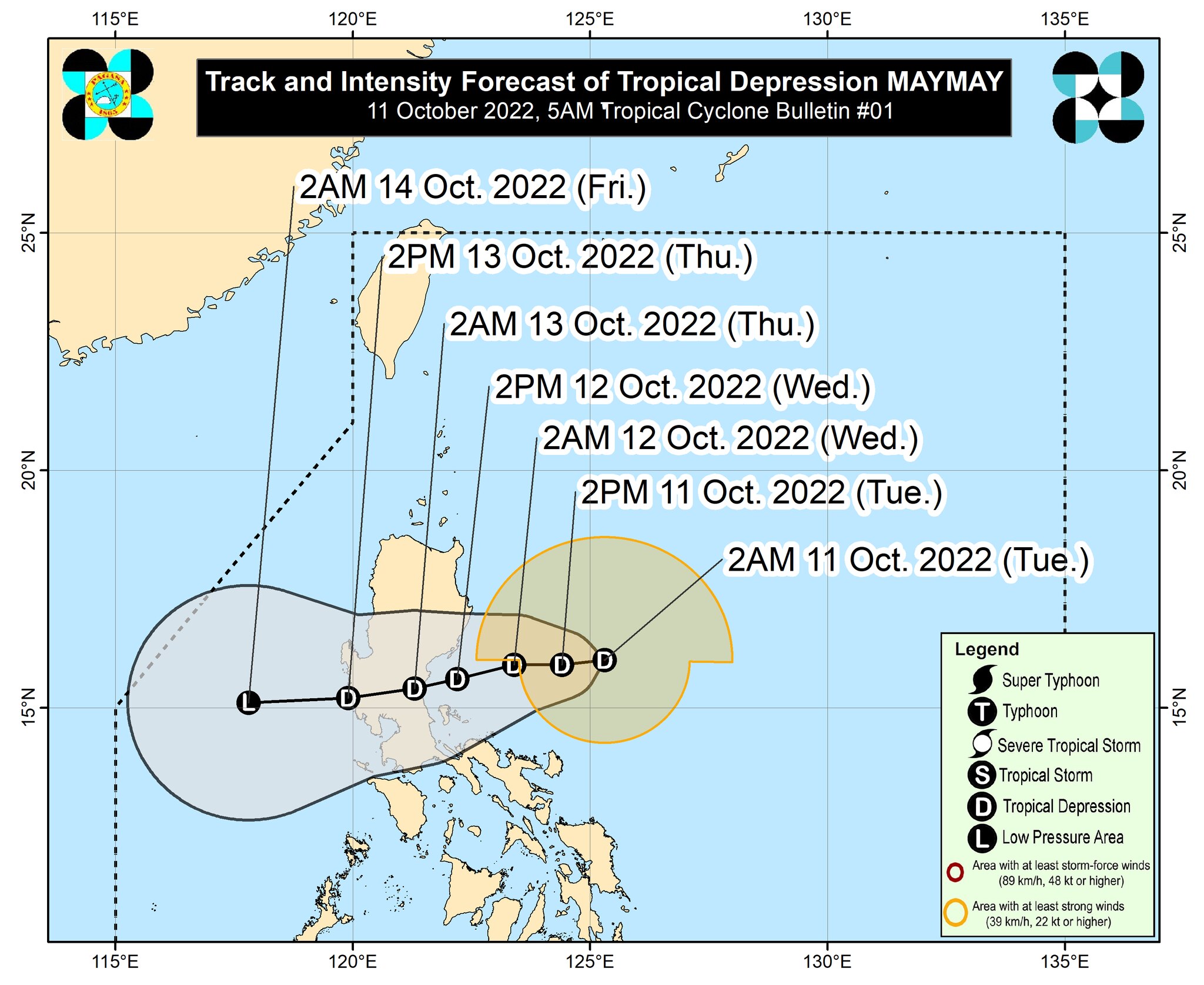
Maymay is expected to make landfall near southern portion of Aurora or northern portion of Quezon Wednesday afternoon or evening. It is then seen to move west southwestward and cross several provinces in Central Luzon before emerging over the West Philippine Sea by Thursday morning or afternoon.
Maymay is expected to make landfall near southern portion of Aurora or northern portion of Quezon Wednesday afternoon or evening. It is then seen to move west southwestward and cross several provinces in Central Luzon before emerging over the West Philippine Sea by Thursday morning or afternoon.
ADVERTISEMENT
Tropical Cyclone Wind Signal no. 1 has been raised over Isabela, Quirino, Nueva Vizcaya, Aurora, Nueva Ecija, and the extreme northern portion of Quezon (General Nakar, Infanta) including Pollilo Islands in anticipation of Maymay's effects.
Tropical Cyclone Wind Signal no. 1 has been raised over Isabela, Quirino, Nueva Vizcaya, Aurora, Nueva Ecija, and the extreme northern portion of Quezon (General Nakar, Infanta) including Pollilo Islands in anticipation of Maymay's effects.
Moderate to heavy with at times intense rains are expected over Cagayan, Isabela, and Apayao. Light to moderate with at times heavy rains are also possible over Batanes, Ilocos Norte, Aurora, and Kalinga, PAGASA said.
Moderate to heavy with at times intense rains are expected over Cagayan, Isabela, and Apayao. Light to moderate with at times heavy rains are also possible over Batanes, Ilocos Norte, Aurora, and Kalinga, PAGASA said.
Meanwhile, PAGASA said it is also monitoring another low pressure area outside PAR.
Meanwhile, PAGASA said it is also monitoring another low pressure area outside PAR.
The LPA was last seen 1,730 km east of Eastern Visayas. It has maximum sustained winds of 45 kph and gustiness of up to 55kph. It is moving north northeastward at 35kph.
The LPA was last seen 1,730 km east of Eastern Visayas. It has maximum sustained winds of 45 kph and gustiness of up to 55kph. It is moving north northeastward at 35kph.
ABS-CBN resident meteoroogist said this weather disturbance will be named Neneng once it enters PAR.
ABS-CBN resident meteoroogist said this weather disturbance will be named Neneng once it enters PAR.
--TeleRadyo, 11 October 2022
Read More:
PAR
Philippine Area of Responsibility
PAGASA
weather
Philippines weather
Philippines latest weather
weather top
Philippines weather news today
ADVERTISEMENT
ADVERTISEMENT