Welcome, Kapamilya! We use cookies to improve your browsing experience. Continuing to use this site means you agree to our use of cookies. Tell me more!
DOST showcases disaster mitigation initiatives in COP28 side event
Ariel Rojas,
ABS-CBN News
Published Dec 08, 2023 02:27 PM PHT
|
Updated Dec 08, 2023 03:04 PM PHT
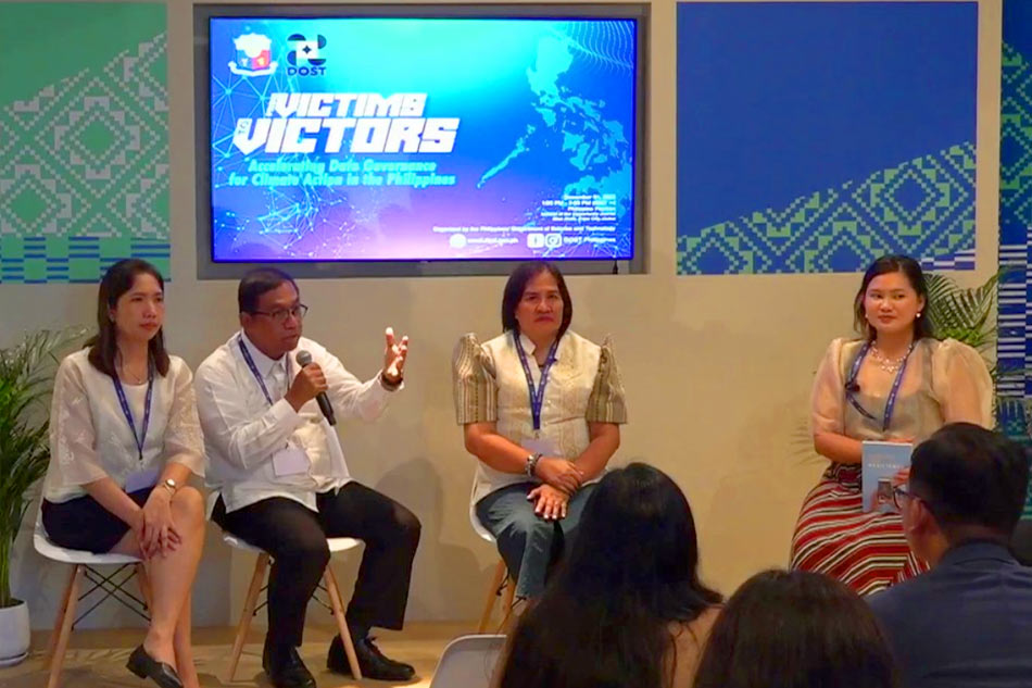
DOST delegation at the COP28 side event, led by Secretary Renato Solidum Jr. DOST
MANILA — The Department of Science and Technology (DOST), led by Secretary Renato Solidum Jr., hosted a side event at the ongoing 28th Conference of Parties (COP28) in Dubai, United Arab Emirates.
The side event, held on December 1, highlighted science and technology interventions (STI) for disaster mitigation.
Two of the department's multi-sectoral collaboration disaster risk reduction (DRR) works were presented, namely, the impact-based forecasting and early warning system, and the GeoRisk Philippines (GeoRisk PH) Initiative.
“One emerging cross-cutting priority is digital transformation. With the frequent experiences of the Philippines to disasters and the imminent threats of climate change, there is a need for robust scientific data that allows us to prevent, adapt, and mitigate. Through data and governance, we change the Filipino narrative of resilience,” said Solidum.
ADVERTISEMENT
The Multi-Hazard Impact-Based Forecasting and Early Warning System for the Philippines Project, funded by the Green Climate Fund, is an initiative to transition from traditional weather forecasting to a more practical and actionable multi-hazard impact-based forecasting and early warning system. PAGASA launched the project in April.
Highlighting the impacts, instead of hazards such as floods, landslides, severe winds, and storm surge, the initiative aims to be more people-focused, allowing enhanced understanding of risks.
"By envisioning the potential disaster risks not just for their community but also for their families and themselves as individuals, people are empowered to make more informed and proactive decisions,” PAGASA climate division head Thelma Cinco explained.
On the other hand, GeoRisk PH is an online resource that shows hazards, exposure, and other risk information necessary for disaster response planning and preparation. Various stakeholders including individuals, communities, private sector, civil society organizations, local governments, and national agencies can access and take advantage of the platform.
Various geospatial information and tools such as hazard maps, risk assessments, early warning systems, and decision support tools are available in its six platforms, including the HazardHunterPH, GeoAnalyticsPH, GeoMapperPH, Map and Feature Services, 3D Earth Risk, and Plan SmartPH.
ADVERTISEMENT
An example of GeoRiskPH application is the calculation of population exposed to tsunami risk, possible tsunami heights based on different earthquake magnitude, and the corresponding affected population, Mabelline Cahulogan of Phivolcs showed in a presentation.
The projects are part of DOST's research agenda, which hopes to bolster local research and development in the fields of climate change, disaster response, and sustainable development.
“We believe that through STI, resilience is possible, and that Filipinos can come out as disaster victors, not disaster victims,” Solidum said.
ABS-CBN is the leading media and entertainment company in the Philippines, offering quality content across TV, radio, digital, and film. Committed to public service and promoting Filipino values, ABS-CBN continues to inspire and connect audiences worldwide.
Our website is made possible by displaying online
advertisements to our visitors. Please consider supporting
us by disabling your ad blocker on our website.
Our website is made possible by displaying online
advertisements to our visitors. Please consider supporting
us by disabling your ad blocker on our website.