Welcome, Kapamilya! We use cookies to improve your browsing experience. Continuing to use this site means you agree to our use of cookies. Tell me more!
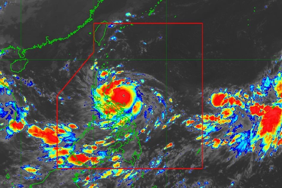
Karding is forecast to continue intensifying prior to its projected landfall in Luzon evening of Sept. 25, 2022. A landfall scenario as a super typhoon is increasingly likely, according to weather state bureau PAGASA. Image from PAGASA
MANILA - Typhoon Karding (international name: Noru) may hit land in the Philippines main island of Luzon as a super typhoon on Sunday evening, state weather bureau PAGASA said.
Karding, the 11th tropical cyclone to hit the country this year, was packing maximum sustained winds of 155 kilometers per hour near the center and gusts of up to 190 kph while in the Pacific Ocean some 285 kilometers east of Infanta, Quezon as of 4 a.m. Sunday, PAGASA said.
"On the forecast track, Karding will likely make landfall in the vicinity of the northern portion of Quezon or the southern portion of Aurora tonight. The possibility of an earlier (afternoon) landfall or close approach in the vicinity of Polillo Islands is not ruled out," PAGASA said in its 5 a.m. bulletin.
'Karding is forecast to continue intensifying prior to landfall. A landfall scenario as a super typhoon is increasingly likely," it added. "The hoisting of Wind Signal No. 5 is increasingly likely."
ADVERTISEMENT
A tropical cyclone with maximum wind speed exceeding 185 kph or more than 100 knots makes it a super typhoon, according to PAGASA.
Karding is forecast to traverse the landmass of Central Luzon and merge over the West Philippine Sea via the coastal waters of Zambales or Pangasinan.
While frictional effects during landfall will weaken the tropical cyclone, it is highly likely that it will remain a typhoon while crossing the landmass, said PAGASA.
Tropical Cyclone Wind Signal No. 3 is currently hoisted in the following areas in Luzon:
the central and southern portions of Aurora (Dingalan, San Luis, Baler, Maria Aurora, Dipaculao)
the extreme northern portion of Quezon (General Nakar, Infanta, Real) including Polillo Islands
the eastern portion of Nueva Ecija (City of Gapan, Bongabon, Gabaldon, Laur, General Tinio, Palayan City, Santa Rosa, Peñaranda, Cabanatuan City, San Leonardo)
the eastern portion of Bulacan (Norzagaray, Doña Remedios Trinidad, Angat, San Rafael, San Ildefonso, San Miguel)
the northern portion of Rizal (Rodriguez, Tanay)
the northern portion of Camarines Norte (Vinzons, Paracale, Jose Panganiban, Capalonga)
Signal No. 2, meanwhile, is up the following areas:
ADVERTISEMENT
the southern portion of Isabela (Dinapigue, San Guillermo, Echague, San Agustin, Jones)
Quirino
Nueva Vizcaya
Benguet
La Union
Pangasinan
Zambales
Bataan
Tarlac
Pampanga
the rest of Bulacan
the rest of Nueva Ecija
the rest of Aurora
Metro Manila
Cavite
Batangas
Laguna
the rest of Rizal
the northern and central portions of Quezon (Mauban, Calauag, Perez, Alabat, Quezon, Tagkawayan, Guinayangan, Sampaloc, Lucban, City of Tayabas, Lucena City, Pagbilao, Padre Burgos, Atimonan, Agdangan, Unisan, Plaridel, Gumaca, Lopez, Pitogo, Dolores, Candelaria, Sariaya, Tiaong, San Antonio, Macalelon, General Luna, Catanauan, Buenavista)
the rest of Camarines Norte
the northern portion of Camarines Sur (Del Gallego, Ragay, Lupi, Sipocot, Libmanan, Pamplona, Pasacao, San Fernando, Pili, Minalabac, Ocampo, Tigaon, Cabusao, Magarao, Gainza, Canaman, Camaligan, Milaor, Naga City, Bombon, Calabanga, Tinambac, Siruma, Goa, Lagonoy, San Jose, Garchitorena, Presentacion, Caramoan, Sagñay)
Catanduanes
The following areas are under Signal No. 1:
the southern portion of Cagayan (Tuao, Solana, Enrile, Tuguegarao City, Iguig, Peñablanca)
the rest of Isabela
the southern portion of Apayao (Conner)
Kalinga
Abra
Mountain Province
Ifugao
the southern portion of Ilocos Norte (Nueva Era, Badoc, Pinili, Banna, City of Batac, Currimao, Paoay, Marcos)
Ilocos Sur
the rest of Quezon
the northern portion of Occidental Mindoro (Abra de Ilog, Paluan, Mamburao, Santa Cruz) including Lubang Islands
the northern portion of Oriental Mindoro (Puerto Galera, San Teodoro, Baco, City of Calapan, Naujan, Victoria, Pola, Socorro, Pinamalayan)
Marinduque
the rest of Camarines Sur
Albay
Sorsogon
Burias Island
Ticao Island
In anticipation of the potential onset of typhoon-force winds, PAGASA said Signal No. 4 will be hoisted in some areas in the next bulletin at 8 a.m.
The weather bureau said that on Sunday morning through early afternoon, moderate to heavy rains are expected over Isabela, Polillo Islands, Catanduanes, Camarines Norte, Camarines Sur, and Isabela.
Light to moderate with at times heavy rains, meanwhile, may be experienced in mainland Cagayan, Quirino, Nueva Vizcaya, Aurora, Quezon, Marinduque, Romblon, and the rest of Bicol Region.
Due to the Southwest Monsoon enhanced by Karding, occasional to monsoon rains are also possible over the Visayas and the rest of Southern Luzon, especially on their western sections, said PAGASA.
ABS-CBN is the leading media and entertainment company in the Philippines, offering quality content across TV, radio, digital, and film. Committed to public service and promoting Filipino values, ABS-CBN continues to inspire and connect audiences worldwide.
Our website is made possible by displaying online
advertisements to our visitors. Please consider supporting
us by disabling your ad blocker on our website.
Our website is made possible by displaying online
advertisements to our visitors. Please consider supporting
us by disabling your ad blocker on our website.