Welcome, Kapamilya! We use cookies to improve your browsing experience. Continuing to use this site means you agree to our use of cookies. Tell me more!
Karding intensifies into severe tropical storm; Signal No. 2 hoisted over Isabela, Aurora
Karding intensifies into severe tropical storm; Signal No. 2 hoisted over Isabela, Aurora
ABS-CBN News
Published Sep 24, 2022 11:44 AM PHT
|
Updated Sep 24, 2022 06:09 PM PHT
PAGASA
Metro Manila, nearby areas under Signal No. 1
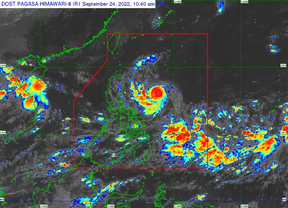
MANILA - Weather disturbance Karding has further intensified and is now a severe tropical storm, state weather bureau PAGASA said Saturday.
Karding intensified into a severe tropical storm at 8 a.m., PAGASA said in its 11 a.m. weather bulletin.
PAGASA also said Karding was last located 660 kilometers east southeast of Tuguegarao City, packing maximum sustained winds of 100 kilometers per hour (kph) near the center, with gusts of up to 125 kph.
It has also accelerated, currently moving west southwestward at 25 kph.
ADVERTISEMENT
Tropical Cyclone Wind Signal No. 2 has been raised over the following areas:
Southeastern portion of Isabela (Dinapigue)
Northern portion of Aurora (Dinalungan, Casiguran, Dilasag), and Pollilo Islands
Meanwhile, the following areas are under Signal No. 1:
Southern portion of Cagayan (Peñablanca, Iguig, Tuguegarao City, Enrile, Solana, Tuao, Piat, Amulung, Rizal)
Rest of Isabela
Quirino
Nueva Vizcaya
Southern portion of Apayao (Conner)
Abra
Kalinga
Mountain Province
Ifugao
Benguet
Southern portion of Ilocos Norte (Nueva Era, Badoc, Pinili, Banna, City of Batac, Currimao, Paoay, Marcos)
Ilocos Sur
La Union
Pangasinan
Rest of Aurora
Nueva Ecija
Tarlac
Bulacan
Pampanga
Zambales
Bataan
Metro Manila
Northern and central portions of Quezon (Tagkawayan, Lopez, Guinayangan, Gumaca, Pitogo, Unisan, Agdangan, Padre Burgos, Pagbilao, City of Tayabas, Lucban, Sampaloc, Mauban, Atimonan, Plaridel, Perez, Alabat, Quezon, Calauag, Lucena City, General Nakar, Real, Infanta)
Rizal
Laguna
Cavite
Northern portion of Batangas (Malvar, Balete, City of Tanauan, Santo Tomas, Talisay, Laurel)
Camarines Norte
Northern and eastern portions of Camarines Sur (Del Gallego, Ragay, Lupi, Sipocot, Siruma, Tinambac, Goa, Lagonoy, Garchitorena, Caramoan, Presentacion, San Jose)
Northern portion of Catanduanes (Pandan, Caramoran, Bagamanoc, Panganiban, Viga, Gigmoto)
Karding is expectd to bring light to moderate with at times heavy rains over Batanes, Cagayan, Isabela, the northern portion of Aurora, Catanduanes, Camarines Norte, and Camarines Sur from Saturday night to early Sunday, while heavy to intense with at times torrential rains may persist over the southern portion of Isabela, Quirino, Nueva Vizcaya, Benguet, La Union, Pangasinan, Aurora, Nueva Ecija, Tarlac, and the northern portion of Zambales from Sunday through Monday.
Moderate to heavy rains are also expected over the rest of central Luzon, while moderate to heavy rains may be experienced over Cagayan, Ilocos provinces, Calabarzon, Metro Manila and the rest of Isabela and Cordillera Administrative Region.
PAGASA
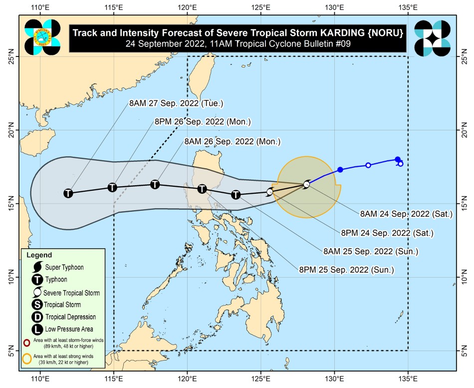
Karding is expected to continue moving west southwest or westward while gradually accelerating towards the east coast of Isabela or Aurora, where it is expected to make landfall Sunday morning or afternoon.
ADVERTISEMENT
After crossing the mountainous terrain of Northern Luzon, it is expected to emerge over the West Philippine Sea late Sunday or early Monday.
PAGASA said Karding is expected to further intensify into a typhoon prior to making landfall over central or northern Luzon.
While it may slightly weaken as it interacts with the land mass in the region, PAGASA said it is still likely that Karding will remain a typhoon while it traverses the landmass.
ABS-CBN News' resident meteorologist Ariel Rojas noted that Karding may affect almost the same areas affected by Tropical Storm Ondoy in 2009, even while the former has a higher track.
Rojas also said heavy rains from Karding, as well as the southwest monsoon, or habagat, should also be taken into consideration.
ADVERTISEMENT
IMPORTANT: Even with a higher track, #KardingPH may affect almost the same areas affected by Ondoy 13 years ago.
Factors to consider: • same geography • more development and population now • more damaging winds from Karding • heavy rains from TC along with Habagat pic.twitter.com/AXw2RPYEiF
Rojas also cited an academic research done in 2016 which explains why storms crossing the Sierra Madre tend to bring more rains to Metro Manila.
“Storms crossing Sierra Madre north of Metro Manila tend to bring more rains in the metropolis due to it being in the windward side of the mountains,” he explained.
In the paper of @bumaBAgyo et al. (2016) on the orographic effect of Sierra Madre to rainfall changes in tropical cyclones, storms cross Sierra Madre north of Metro Manila tend to bring more rains in the metropolis due to it being in the windward side of the mountains. pic.twitter.com/PDQt0d71SW
Tropical Storm Ondoy, which made landfall near the boundary of Aurora and Quezon provinces on September 26, 2009, submerged communities as it dumped 455 millimeters or a month's volume of rain across Luzon for 6 hours.
A total of 1,785 barangays from 154 municipalities and 30 cities across 12 affected regions in the country were flooded. It included 239 barangays in Metro Manila.
Ondoy affected over 4.9 million people, with over 70,000 brought to evacuation centers.
ADVERTISEMENT
According to the National Disaster Risk Reduction and Management Council, the storm left 464 people dead, 529 injured and 37 missing, while estimated cost of damage to infrastructure and agriculture amounted to P11 billion.
ABS-CBN is the leading media and entertainment company in the Philippines, offering quality content across TV, radio, digital, and film. Committed to public service and promoting Filipino values, ABS-CBN continues to inspire and connect audiences worldwide.
Our website is made possible by displaying online
advertisements to our visitors. Please consider supporting
us by disabling your ad blocker on our website.
Our website is made possible by displaying online
advertisements to our visitors. Please consider supporting
us by disabling your ad blocker on our website.