Signal no. 4 up in Cagayan, northern Isabela as Ompong approaches | ABS-CBN


Welcome, Kapamilya! We use cookies to improve your browsing experience. Continuing to use this site means you agree to our use of cookies. Tell me more!
Signal no. 4 up in Cagayan, northern Isabela as Ompong approaches
Signal no. 4 up in Cagayan, northern Isabela as Ompong approaches
ABS-CBN News
Published Sep 14, 2018 05:25 PM PHT
|
Updated Sep 14, 2018 09:04 PM PHT
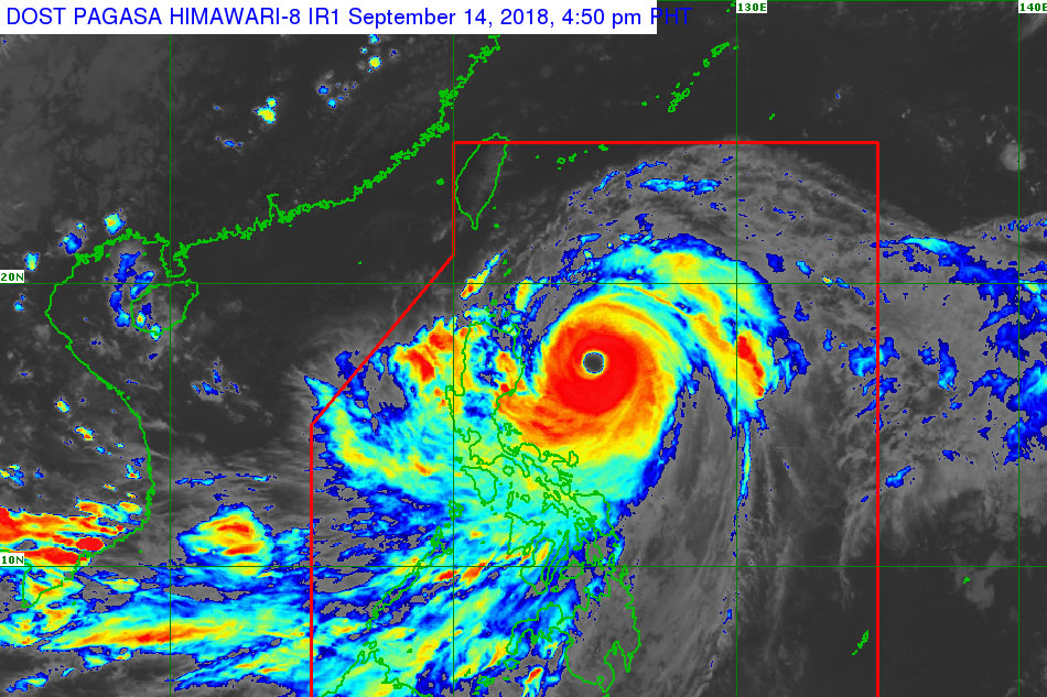
MANILA (UPDATE) - Cagayan and northern Isabela were placed under the second highest tropical cyclone warning signal Friday as Typhoon Ompong (international name: Mangkhut) approached for landfall.
MANILA (UPDATE) - Cagayan and northern Isabela were placed under the second highest tropical cyclone warning signal Friday as Typhoon Ompong (international name: Mangkhut) approached for landfall.
State weather bureau PAGASA placed the two areas under Tropical Cyclone Warning Signal No. 4 as winds of 171 to 220 kilometers per hour (kph) were expected to be felt within the next 12 hours.
State weather bureau PAGASA placed the two areas under Tropical Cyclone Warning Signal No. 4 as winds of 171 to 220 kilometers per hour (kph) were expected to be felt within the next 12 hours.
The typhoon is likely to make landfall around 4 a.m. Saturday, PAGASA weather specialist Gener Quitlong and ABS-CBN resident weather specialist Nilo Millanes said.
The typhoon is likely to make landfall around 4 a.m. Saturday, PAGASA weather specialist Gener Quitlong and ABS-CBN resident weather specialist Nilo Millanes said.
Ompong, the strongest typhoon to hit the Philippines this year, slightly gained speed and is now moving northwest at 30 kph from 25 kph Friday afternoon, PAGASA said.
Ompong, the strongest typhoon to hit the Philippines this year, slightly gained speed and is now moving northwest at 30 kph from 25 kph Friday afternoon, PAGASA said.
ADVERTISEMENT
As of 4 p.m., Ompong was last spotted 340 kms east northeast of Casiguran, Aurora, still packing maximum sustained winds of 205 kph with 255 kph gusts.
As of 4 p.m., Ompong was last spotted 340 kms east northeast of Casiguran, Aurora, still packing maximum sustained winds of 205 kph with 255 kph gusts.
The following Tropical Cyclone Warning Signals are hoisted over these areas:
The following Tropical Cyclone Warning Signals are hoisted over these areas:
SIGNAL NO. 3
SIGNAL NO. 3
- Babuyan group of islands
- Ilocos Norte
- Ilocos Sur
- Apayao
- Abra
- Kalinga
- Mountain Province
- Ifugao
- Benguet
- Nueva Vizcaya
- Quirino
- Northern Aurora
- Southern Isabela
- Babuyan group of islands
- Ilocos Norte
- Ilocos Sur
- Apayao
- Abra
- Kalinga
- Mountain Province
- Ifugao
- Benguet
- Nueva Vizcaya
- Quirino
- Northern Aurora
- Southern Isabela
SIGNAL NO. 2
SIGNAL NO. 2
- Batanes
- La Union
- Pangasinan
- Tarlac
- Nueva Ecija
- Southern Aurora
- Northern Zambales
- Batanes
- La Union
- Pangasinan
- Tarlac
- Nueva Ecija
- Southern Aurora
- Northern Zambales
SIGNAL NO. 1
SIGNAL NO. 1
- Southern Zambales
- Pampanga
- Bulacan
- Bataan
- Rizal
- Metro Manila
- Cavite
- Batangas
- Laguna
- Quezon including Polillo Island
- Northern Occidental Mindoro including Lubang Island
- Northern Oriental Mindoro
- Masbate
- Marinduque
- Camarines Norte
- Camarines Sur
- Catanduanes
- Albay
- Sorsogon
- Burias and Ticao Islands
Storm surges of up to 6 meters above mean sea level are possible in coastal areas in Cagayan, Isabela and Ilocos region where the storm will hit land first, PAGASA said.
Storm surges of up to 6 meters above mean sea level are possible in coastal areas in Cagayan, Isabela and Ilocos region where the storm will hit land first, PAGASA said.
Meanwhile, scattered rainshowers will be experienced over the Visayas, MIMAROPA, northern Mindanao, Zamboanga peninsula and the CARAGA region due to the trough of Typhoon Ompong and the southwest monsoon.
Meanwhile, scattered rainshowers will be experienced over the Visayas, MIMAROPA, northern Mindanao, Zamboanga peninsula and the CARAGA region due to the trough of Typhoon Ompong and the southwest monsoon.
Government has initiated urgent preparations in areas on the path of the storm, evacuating thousands, readying relief supplies, and prompting farmers to harvest their crops ahead of Ompong's onslaught.
Government has initiated urgent preparations in areas on the path of the storm, evacuating thousands, readying relief supplies, and prompting farmers to harvest their crops ahead of Ompong's onslaught.
Ompong is expected to exit the Philippine area of responsibility by Sunday morning.
Ompong is expected to exit the Philippine area of responsibility by Sunday morning.
Visit the ABS-CBN Weather Center for the latest weather updates.
ADVERTISEMENT
ADVERTISEMENT