Cagayan, 3 other areas under Signal No. 4 as Ompong nears land | ABS-CBN


ADVERTISEMENT

Welcome, Kapamilya! We use cookies to improve your browsing experience. Continuing to use this site means you agree to our use of cookies. Tell me more!
Cagayan, 3 other areas under Signal No. 4 as Ompong nears land
Cagayan, 3 other areas under Signal No. 4 as Ompong nears land
ABS-CBN News
Published Sep 14, 2018 09:01 PM PHT
|
Updated Sep 14, 2018 11:43 PM PHT
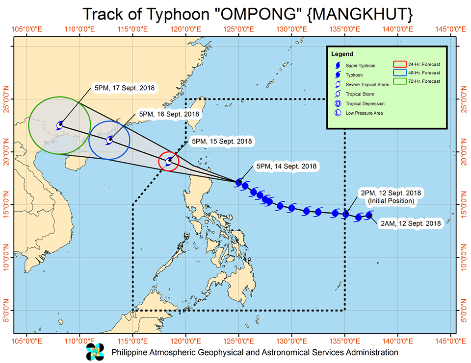
MANILA- Four areas were placed under the second highest tropical cyclone warning signal Friday night, as Typhoon Ompong (international name: Mangkhut) nears landfall.
MANILA- Four areas were placed under the second highest tropical cyclone warning signal Friday night, as Typhoon Ompong (international name: Mangkhut) nears landfall.
State weather bureau PAGASA placed Cagayan, northern Isabela, Apayao, and Abra under Tropical Cyclone Warning Signal No. 4 as winds of 171 kph to 220 kph are expected to be felt within the next 12 hours.
State weather bureau PAGASA placed Cagayan, northern Isabela, Apayao, and Abra under Tropical Cyclone Warning Signal No. 4 as winds of 171 kph to 220 kph are expected to be felt within the next 12 hours.
Ompong is expected to make landfall in the Cagayan-Isabela area
between 1 a.m. to 3 a.m Saturday, PAGASA weather specialist Lorie Dela Cruz said
Ompong is expected to make landfall in the Cagayan-Isabela area
between 1 a.m. to 3 a.m Saturday, PAGASA weather specialist Lorie Dela Cruz said
The strongest typhoon to hit the Philippines this year, Ompong maintained its speed of 30 kph and continues to move northwest.
The strongest typhoon to hit the Philippines this year, Ompong maintained its speed of 30 kph and continues to move northwest.
ADVERTISEMENT
At 7 p.m., the center of the typhoon was spotted at 260 kilometers east, northeast of Casiguran, Aurora. It continues to pack maximum sustained winds of 205 kph with 255 kph gusts.
At 7 p.m., the center of the typhoon was spotted at 260 kilometers east, northeast of Casiguran, Aurora. It continues to pack maximum sustained winds of 205 kph with 255 kph gusts.
The following tropical cyclone warning signals are hoisted over the following areas:
The following tropical cyclone warning signals are hoisted over the following areas:
SIGNAL NO. 3
- Batanes
- Babuyan group of islands
- Ilocos Norte
- Ilocos Sur
- La Union
- Kalinga
- Mountain Province
- Benguet
- Ifugao
- Nueva Vizcaya
-Quirino
- Northern Aurora
- Southern Isabela
- Batanes
- Babuyan group of islands
- Ilocos Norte
- Ilocos Sur
- La Union
- Kalinga
- Mountain Province
- Benguet
- Ifugao
- Nueva Vizcaya
-Quirino
- Northern Aurora
- Southern Isabela
SIGNAL NO. 2
- Pangasinan
- Tarlac
- Nueva Ecija
- Southern Aurora
- Zambales
- Pampanga
- Bulacan
-Northern Quezon including Polilo Island
- Pangasinan
- Tarlac
- Nueva Ecija
- Southern Aurora
- Zambales
- Pampanga
- Bulacan
-Northern Quezon including Polilo Island
SIGNAL NO. 1
- Bataan
- Rizal
- Metro Manila
- Cavite
- Batangas
- Laguna
- Rest of Quezon
- Northern Occidental Mindoro including Lubang Island
- Northern Oriental Mindoro
- Masbate
- Marinduque
- Camarines Norte
- Camarines Sur
- Catanduanes
- Albay
- Sorsogon
- Burias and Ticao Islands
- Bataan
- Rizal
- Metro Manila
- Cavite
- Batangas
- Laguna
- Rest of Quezon
- Northern Occidental Mindoro including Lubang Island
- Northern Oriental Mindoro
- Masbate
- Marinduque
- Camarines Norte
- Camarines Sur
- Catanduanes
- Albay
- Sorsogon
- Burias and Ticao Islands
ADVERTISEMENT
Storm surges of up to 6 meters above mean sea level are possible in coastal areas in Cagayan and Ilocos Norte early Satuday morning, while storm surges up to 2 meters above mean sea level are possible in Isabela and Ilocos Sur, PAGASA said.
Storm surges of up to 6 meters above mean sea level are possible in coastal areas in Cagayan and Ilocos Norte early Satuday morning, while storm surges up to 2 meters above mean sea level are possible in Isabela and Ilocos Sur, PAGASA said.
Occasional moderate to heavy rains may prevail over Visayas while scattered light to moderate to at times heavy rains may be experienced in Palawan, Zamboanga Peninsula, Northern Mindanao, and Caraga due to the southwest monsoon (Habagat) enhanced by Ompong.
Occasional moderate to heavy rains may prevail over Visayas while scattered light to moderate to at times heavy rains may be experienced in Palawan, Zamboanga Peninsula, Northern Mindanao, and Caraga due to the southwest monsoon (Habagat) enhanced by Ompong.
Residents in these areas, especially those living near river channels, in low-lying areas, and in mountainous areas, are advised to take appropriate actions against possible flooding and landslides.
Residents in these areas, especially those living near river channels, in low-lying areas, and in mountainous areas, are advised to take appropriate actions against possible flooding and landslides.
Ompong is expected to exit the Philippine area of responsibility by Sunday afternoon.
Ompong is expected to exit the Philippine area of responsibility by Sunday afternoon.
Visit the ABS-CBN Weather Center for the latest weather updates.
ADVERTISEMENT
ADVERTISEMENT