Welcome, Kapamilya! We use cookies to improve your browsing experience. Continuing to use this site means you agree to our use of cookies. Tell me more!
Typhoon Inday continues to intensify over Philippine Sea
Typhoon Inday continues to intensify over Philippine Sea
ABS-CBN News
Published Sep 11, 2022 12:09 AM PHT
|
Updated Sep 11, 2022 08:15 AM PHT
credit: RAMMB/NOAA/Himawari 8
MANILA — Typhoon Inday continued to intensify as it moved northwestward over the Philippine Sea, PAGASA said Saturday night.
In its bulletin issued 11 p.m., the state weather bureau said Inday may bring heavy rains over the extreme Northern Luzon and the western sections of Central and Southern Luzon.
The eye of Typhoon Inday was last spotted 380 kilometers east of Itbayat, Batanes, with maximum sustained winds of 140 kilometers per hour near the center and gustiness of up to 170 kilometers per hour.
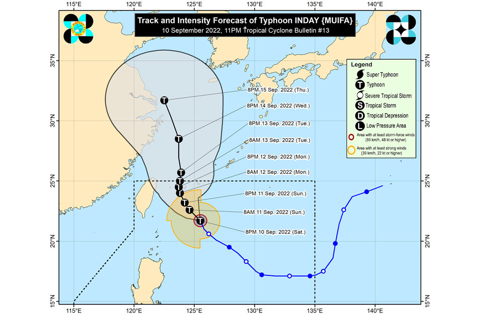
Typhoon Inday forecast track. PAGASA
It is moving northwestward at 15 kilometers per hour.
ADVERTISEMENT
PAGASA also said Inday is forecast to move over the Philippine Sea until Sunday as it tracks towards the sea east of Taiwan before turning slowly north northwestward to northward on Monday.
The typhoon may exit the Philippine Area of Responsibility (PAR) by Tuesday.
"Further intensification will continue until Monday as Inday tracks northwestward over the Philippine Sea. However, the slightly cooler waters east of Taiwan and the forecast slow-down period over this sea area may result in a weakening trend beginning on Tuesday," the state weather bureau said.
ABS-CBN is the leading media and entertainment company in the Philippines, offering quality content across TV, radio, digital, and film. Committed to public service and promoting Filipino values, ABS-CBN continues to inspire and connect audiences worldwide.
Our website is made possible by displaying online
advertisements to our visitors. Please consider supporting
us by disabling your ad blocker on our website.
Our website is made possible by displaying online
advertisements to our visitors. Please consider supporting
us by disabling your ad blocker on our website.