Welcome, Kapamilya! We use cookies to improve your browsing experience. Continuing to use this site means you agree to our use of cookies. Tell me more!
'Jolina' makes landfall in Batangas, 'Kiko' slightly intensifies: PAGASA
'Jolina' makes landfall in Batangas, 'Kiko' slightly intensifies: PAGASA
Gillan Ropero,
ABS-CBN News
Published Sep 08, 2021 12:30 PM PHT
|
Updated Sep 08, 2021 07:13 PM PHT
PAGASA
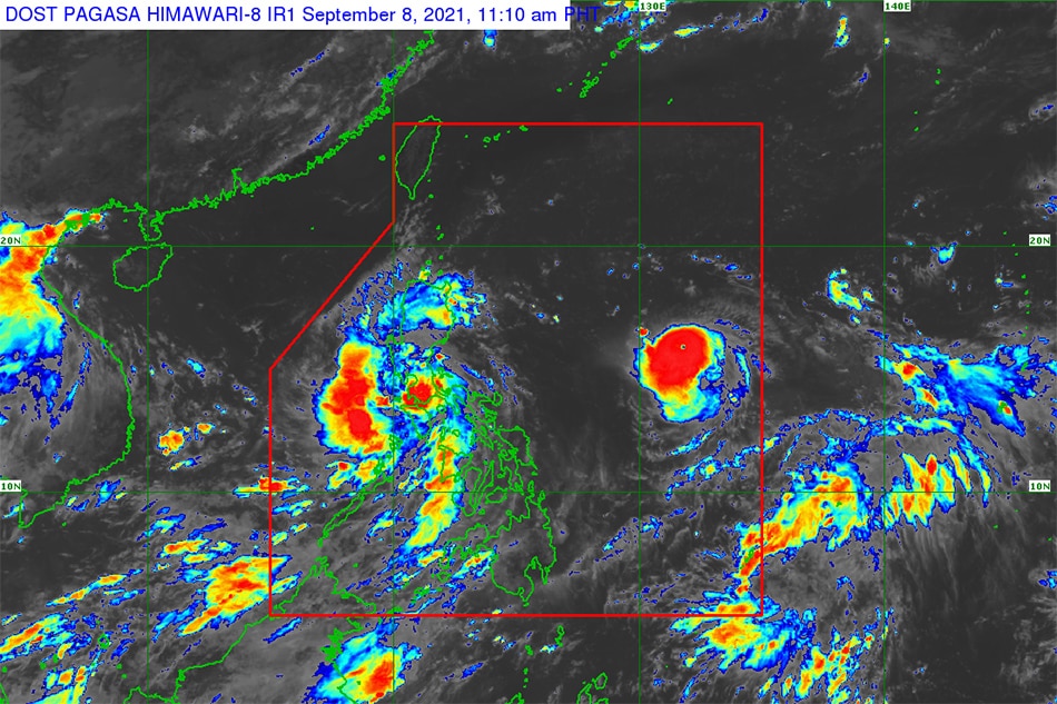
MANILA— Severe tropical storm Jolina made another landfall over San Juan town, Batangas while another typhoon slightly intensified over the Philippine Sea on Wednesday morning, the state weather bureau said.
This would be the eighth time Jolina hit land, PAGASA weather forecaster Joey Figuracion earlier told ABS-CBN's TeleRadyo.
The country's 10th storm this year was last estimated in the vicinity of Rosario, Batangas at 10 a.m., moving northwest at 10 kilometers per hour, PAGASA said in its 11 a.m. bulletin.
Jolina kept it strength and was packing maximum winds of 95 kph near the center with gusts of up to 130 kph, it added.
ADVERTISEMENT
Tropical cyclone wind signal no. 2, which warns of damaging gale-force to storm-force winds within 24 hours, was raised over the following areas:
Metro Manila
Marinduque
Northern and central portions of Oriental Mindoro
Northern and central portions of Occidental Mindoro including Lubang Islands
Central and southern portions of Quezon
Batangas
Cavite
Laguna
Rizal
Southern portion of Bulacan
Pampanga
Bataan
Zambales
Tarlac
Tropical cyclone wind signal no. 1, which warns of strong winds prevailing within 24 hours, was hoisted over:
La Union
Southern portion of Benguet
Southern portion of Nueva Vizcaya
Southern portion of Aurora
Pangasinan
Nueva Ecija
Rest of Bulacan
Rest of Quezon including Polillo Islands
Camarines Norte
Western portion of Camarines Sur
Western portion of Romblon
Rest of Oriental Mindoro
Rest of Occidental Mindoro
In the next 24 hours, heavy to intense with at times torrential rains will be experienced over Metro Manila, Bataan, Marinduque, Cavite, Laguna, Batangas, Rizal, Quezon, Occidental Mindoro, and Oriental Mindoro, according to the weather bureau.
Moderate to heavy with at times intense rains are expected over Aurora, Bulacan, Nueva Ecija, Pampanga, Tarlac, Zambales, Camarines Sur, Camarines Norte, Romblon, Marinduque, the northern portion of Palawan including Calamian and Cuyo Islands, Aklan, Antique, Capiz, Iloilo, Guimaras, and Negros Occidental.
Light to moderate with at times heavy rains will prevail over Ilocos Region, Cordillera Administrative Region, and Cagayan Valley.
ADVERTISEMENT
PAGASA warned residents that scattered to widespread flooding (including flash floods) and rain-induced landslides are highly likely especially in areas that are highly susceptible to these hazards.
It also warned that the storm would bring rough to very rough seas (2.5 to 5.5 m) over the seaboards of areas where signal number 2 was raised.
Jolina is forecast to leave the Philippine Area of Responsibility between Thursday evening and early Friday.
Typhoon Kiko, last estimated at 1,120 km east of Central Luzon, has slightly intensified as it moved over the Philippine Sea, PAGASA said.
The storm was moving west southwest at 20 kph while packing maximum sustained winds of 155 kph and 190 kph gustiness, it said.
ADVERTISEMENT
Heavy rains associated with the typhoon may begin affecting the eastern part of northern Luzon on Friday, it added.
ABS-CBN is the leading media and entertainment company in the Philippines, offering quality content across TV, radio, digital, and film. Committed to public service and promoting Filipino values, ABS-CBN continues to inspire and connect audiences worldwide.
Our website is made possible by displaying online
advertisements to our visitors. Please consider supporting
us by disabling your ad blocker on our website.
Our website is made possible by displaying online
advertisements to our visitors. Please consider supporting
us by disabling your ad blocker on our website.