Welcome, Kapamilya! We use cookies to improve your browsing experience. Continuing to use this site means you agree to our use of cookies. Tell me more!
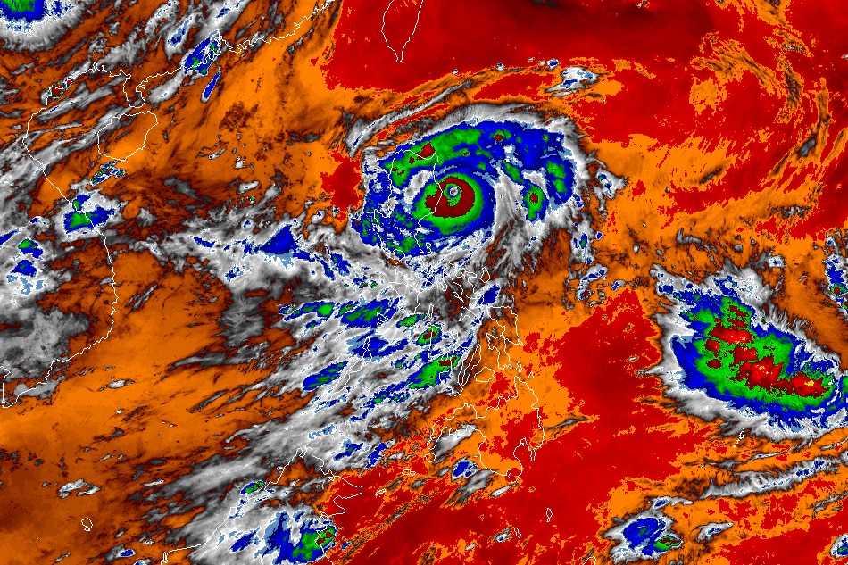
MANILA (UPDATED) — Super typhoon Goring (international name Saola) maintained its strength while moving south-southwestward, bringing heavy rains over vast swaths of the country, the state weather bureau said Sunday.
At 11 a.m., Goring was spotted around 95 kilometers east northeast of Casiguran, Aurora. It was packing maximum sustained winds of 185 kilometers per hour near the center and up to 230 kph gusts, PAGASA said.
The super typhoon will dump an accumulated rainfall greater than 200 mm or nearly 8 inches over the extreme eastern portion of Isabela on Sunday, the weather agency said.
The eastern portions of mainland Cagayan and Isabela will experience 100-200 mm (nearly 4 to 8 inches) of rainfall, while Ilocos Region, Apayao, Abra, Benguet, the northern portion of Aurora, the eastern portion of Nueva Vizcaya, and rest of mainland Cagayan and Isabela should expect 50 to 100 mm (2 to 4 inches) of rain.
ADVERTISEMENT
"Under these conditions, flooding and rain-induced landslides are possible especially in areas that are highly or very highly susceptible to these hazards," the weather forecaster warned.
Goring will also enhance the southwest monsoon, which will bring occasional rains over the western portions of Central Luzon, Southern Luzon, and Visayas over the next three days, PAGASA said.
In its 11 a.m. bulletin, PAGASA hoisted tropical cyclone wind signal no. 3 over the eastern portion of Isabela (Divilacan, Palanan, Dinapigue, Ilagan City, and San Mariano). These areas will experience 89 to 117 kph winds in at least 18 hours.
PAGASA also raised the following wind signals.
SIGNAL NO. 2
Eastern portion of mainland Cagayan (Peñablanca, Baggao, Gattaran, Lal-Lo, Gonzaga, Santa Teresita, Buguey, Santa Ana, Enrile, Tuguegarao City)
Northern and central portion of Isabela (Maconacon, Cabagan, Tumauini, San Pablo, Benito Soliven, San Guillermo, Jones, Echague, San Agustin, Angadanan, City of Cauayan, Naguilian, Gamu, Santa Maria, Santo Tomas, Delfin Albano, Quirino, Burgos, Reina Mercedes, Alicia, Luna, Quezon, Mallig, Roxas, San Manuel, Aurora, Cabatuan, San Mateo, San Isidro)
Extreme northern portion of Aurora (Casiguran, Dinalungan, Dilasag)
Eastern portion of Quirino (Maddela)
SIGNAL NO. 1
Batanes
Rest of Cagayan including Babuyan Islands
Rest of Aurora
Rest of Quirino
Rest of Isabela
Apayao
Nueva Vizcaya
Ifugao
Mountain Province
Kalinga
Abra
Eastern portion of Ilocos Norte (Pagudpud, Adams, Vintar, Carasi, Nueva Era, Banna, Marcos, Dingras, Solsona, Piddig, Dumalneg, Bangui)
Pollilo Islands
Eastern portion of Benguet (Bokod, Buguias, Kabayan, Mankayan)
Eastern portion of Nueva Ecija (Carranglan, Pantabangan, Bongabon, Gabaldon, Laur, Rizal)
Calaguas Islands
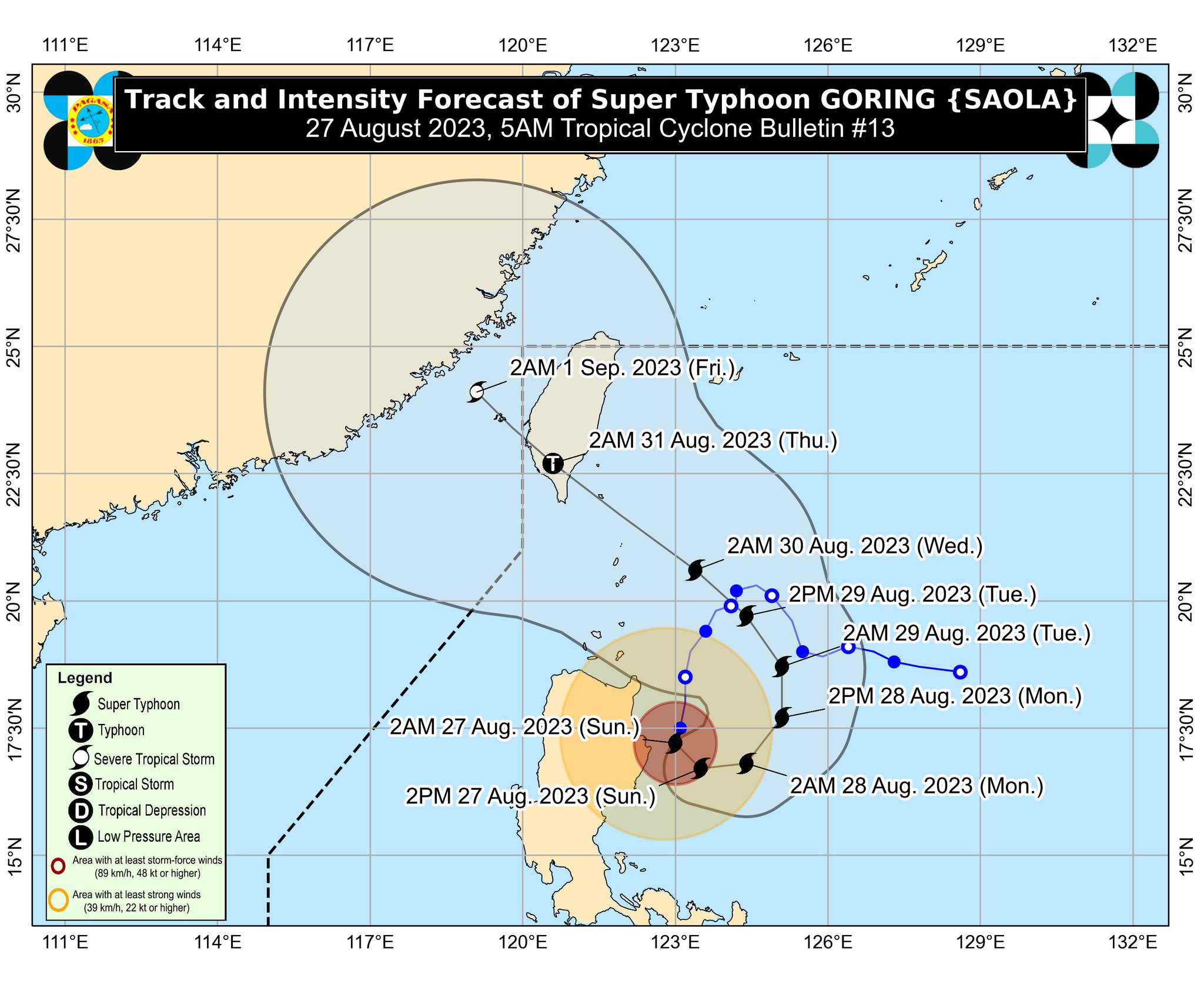
Track and intensity forecast for super typhoon Goring. PAGASA
Goring is expected to begin its loop over the Philippine Sea east of Cagayan-Isabela area on Sunday. The super typhoon will then turn northeastward and northward on Monday before shifting to a more northwestward movement on Tuesday, PAGASA said.
On Wednesday evening or Thursday morning, Goring will make landfall over the southern portion of Taiwan, it added.
ABS-CBN is the leading media and entertainment company in the Philippines, offering quality content across TV, radio, digital, and film. Committed to public service and promoting Filipino values, ABS-CBN continues to inspire and connect audiences worldwide.
Our website is made possible by displaying online
advertisements to our visitors. Please consider supporting
us by disabling your ad blocker on our website.
Our website is made possible by displaying online
advertisements to our visitors. Please consider supporting
us by disabling your ad blocker on our website.